
Another deadly derecho in United States
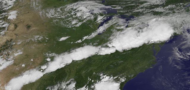
Image credit: NOAA GOES 13 NASA/GSFC
A huge outbreak of severe thunderstorms hit United States on Thursday, July 26, 2012 causing damage in fifteen states and knocking out power to over 250,000 customers. Severe thunderstorm warnings were in effect for 132 counties in 15 states along but it was not as nearly as violent as the June 29 – 30 Mid-Atlantic and Midwest derecho. It can be, however, classifed as a derecho, since it met the main criteria, as defined by NOAA’s SPC.
“A derecho is a widespread, long-lived wind storm that is associated with a band of rapidly moving showers or thunderstorms. Although a derecho can produce destruction similar to that of tornadoes, the damage typically is directed in one direction along a relatively straight swath. As a result, the term “straight-line wind damage” sometimes is used to describe derecho damage. By definition, if the wind damage swath extends more than 240 miles (about 400 kilometers) and includes wind gusts of at least 58 mph (93 km/h) or greater along most of its length, then the event may be classified as a derecho.”
Three people were reportedly killed. The severe storms covered an unusually large area, erupting along a 1,500-mile long swath of the country from Texas to Connecticut.

Tornadoes touched down in the Pennsylvania towns of Coudersport and Montrose on Thursday. The one in Coudersport was rated an EF-1 with a maximum wind speed of 90 mph, and the Montrose one was an EF-0 with maximum winds of 80 mph, the National Weather Service said. NWS also reported that damage in Elmira, New York, was caused by an EF-1 tornado with estimated maximum wind speeds as high as 110 mph.
The intensity of the thunderstorms was increased by a very hot and moist air mass; temperatures in the mid to upper 90s were common across the region on Thursday. A number of record highs for the date were set, including a 98° reading at Washington D.C.’s Dulles Airport. The threat of severe weather continues for Friday afternoon over portions of the Ohio Valley and mid-Atlantic, as NOAA’s Storm Prediction Center has placed these regions in their “Slight Risk” area for severe thunderstorms.
Storm from June 29, 2012 was one of the most destructive and deadly severe thunderstorm complexes in North American history. It killed 22 people, knocked out power to at least 3.7 million customers, and did hundreds of millions in damage.
Friday – Saturday forecast (July 27 – July 28, 2012)
This is how east US looked like from NOAA’s GOES 13 satellite on July 27, 2012 at 22:10 UTC:


National Weather Service warning W534
effective this Friday night and Saturday morning from 7:15 pm until 3:00 am edt.
The NWS SPC center has issued a severe thunderstorm watch for portions of
NORTHEAST KENTUCKY
FAR SOUTHEAST OHIO
WESTERN WEST VIRGINIA
Earlier SPC warnings:
NWS SPC WARNING W533:
SEVERE THUNDERSTORMS: July, 27 2012 (22:25 UTC) – July 28, 2012 (06:00 UTC)
The NWS SPC center has issued a severe thunderstorm watch for portions of:
WESTERN SOUTH DAKOTA
EFFECTIVE THIS FRIDAY AFTERNOON FROM 4:25 PM UNTIL MIDNIGHT MDT.
Hail to 2 inches in diameter…thunderstorm wind gusts to 70
mph, and dangerous lightning are possible in these areas.
The severe thunderstorm watch area is approximately along and 65
statute miles east and west of a line from 90 miles north
northeast of rapid city South Dakota to 70 miles south southeast
of rapid city South Dakota.
Remember…a severe thunderstorm watch means conditions are
favorable for severe thunderstorms in and close to the watch
area. Persons in these areas should be on the lookout for
threatening weather conditions and listen for later statements
and possible warnings. Severe thunderstorms can and occasionally
do produce tornadoes.
Discussion…widely scattered thunderstorms are anticipated to develop
across the watch area this evening in advance of a weak midlevel
impulse cresting mean ridge axis. Air mass is characterized by
steep low to midlevel lapse rates and a deeply mixed boundary layer.
When coupled with around 40 kt of deep-layer shear…setup will
promote high-based supercells which may transition to a small mcs
this evening with the primary hazards being damaging winds and some
hail.
Aviation…a few severe thunderstorms with hail surface and aloft
to 2 inches. Extreme turbulence and surface wind gusts to 60
knots. A few cumulonimbi with maximum tops to 500. Mean storm
motion vector 27025.
NWS SPC warning W532 included:
The NWS Storm Prediction Center has issued a severe thunderstorm watch for portions of
INDIANA
NORTHERN KENTUCKY
SOUTHERN LOWER MICHIGAN
WESTERN AND NORTHERN OHIO
LAKE ERIE
…effective this friday afternoon and evening from 2:45 pm until 11:00 pm edt.
Sources: NOAA SPC, weather.gov
I'm a dedicated researcher, journalist, and editor at The Watchers. With over 20 years of experience in the media industry, I specialize in hard science news, focusing on extreme weather, seismic and volcanic activity, space weather, and astronomy, including near-Earth objects and planetary defense strategies. You can reach me at teo /at/ watchers.news.
Commenting rules and guidelines
We value the thoughts and opinions of our readers and welcome healthy discussions on our website. In order to maintain a respectful and positive community, we ask that all commenters follow these rules.