
Three storms swirling across Pacific Ocean
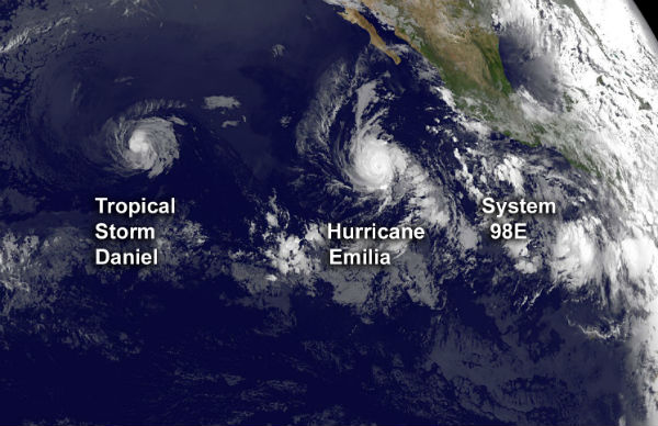
Featured image: A satellite image taken by the GOES-15 satellite on July 10, 2012, which shows three storm systems trailing one another across the ocean basin. (Credit: NOAA/NASA)
Three storm systems are trailing one another across the Pacific Ocean basin. Tropical Storm Daniel is moving west toward Hawaii, followed by Hurricane Emilia. Just off the coast of Mexico, another possible tempest, known as System 98E, is brewing. National Hurricane Center in Miami gave this system an 80 % chance of becoming a tropical cyclone in the next 48 hours.
Daniel is now a tropical storm once more after weaken from Category 2 hurricane status. Currently, it is located 1700 km (about 1055 miles) east-southeast of the Hawaiian Islands.

Satellite Animations
- Storm-Centered Infrared (GOES 15; NOAA/SSD)
- Storm-Centered Infrared (Aviation Color Enhancement) (GOES 15; NOAA/SSD)
- Storm-Centered Water Vapor (GOES 15; NOAA/SSD)
- Storm-Centered Visible (GOES 15; NOAA/SSD)
- Storm-Centered Visible (Colorized) (GOES 15; NOAA/SSD)
- Tropical East Pacific Hurricane Sector Infrared (GOES 15; NOAA)
- Tropical East Pacific Hurricane Sector Water Vapor (GOES 15; NOAA)
- Tropical East Pacific Hurricane Sector Visible (GOES 15; NOAA)
Emilia grew rapidly and become a Category 4 hurricane, the strongest storm of the season so far in either the Pacific or Atlantic basins. Emilia has weakened slightly and today is a Category 2 hurricane, packing winds of up to 170 km/h (105 mph), according to the latest report from the National Hurricane Center.

System is located 1205 km (750 miles) southwest of the southern tip of Baja California. Emilia is moving west-northwestward at speed of 15 km/h (9 mph) and this general motion is expected to continue for the next two days. Maximum sustained winds remain near 165 km/h (105 mph) with higher gusts. Hurricane force winds extend outward up to 45 km (30 miles) from the center and tropical storm winds extend outward up to 165 km (105 miles) from the center. Estimated minimum pressure is 970 MB.

Satellite Animations
- Storm-Centered Infrared (GOES 15; NOAA/SSD)
- Storm-Centered Infrared (Aviation Color Enhancement) (GOES 15; NOAA/SSD)
- Storm-Centered Water Vapor (GOES 15; NOAA/SSD)
- Storm-Centered Visible (GOES 15; NOAA/SSD)
- Storm-Centered Visible (Colorized) (GOES 15; NOAA/SSD)
- Central Pacific Infrared (GOES 15; NOAA)
- Central Pacific Infrared (Aviation Color Enhancement) (GOES 15; NOAA)
- Central Pacific Water Vapor (GOES 15; NOAA)
- Central Pacific Visible (GOES 15; NOAA)
- Central Pacific Visible (Colorized) (GOES 15; NOAA)
Shower activity associated with a Low Pressure System 98E located about 765 km (475 miles) south of Manzanillo, Mexico, continues to show signs of organization. Environmental conditions are conductive for development and a tropical depression could form during the next day or so. The system is moving west-northwestward at speed of 16 km/h (10 mph).

Sources: US National Hurricane Center, Central Pacific Hurricane Center Hawaii, Joint Typhoon Warning Center, MODIS Rapid Response Team

Published in the last 24 hours
- Cyclone Akvan crossed the north Andhra Pradesh and south Odisha coasts close to Gopalpur on November 20 with 70-80 km/h winds gusting to 90, and has weakened into a deep depression
- High Risk of excessive rainfall covers Florida’s Space Coast as St. Johns River near Cocoa reaches 5.67 m
- Asteroid 2026 WJ to pass Earth at 1.7 lunar distances at 04:20 UTC on November 22, with 2026 WD following at 4.4 lunar distances on November 23
- A broad low over southeastern Florida and the northwestern Bahamas has a 30 percent chance of subtropical or tropical development within 48 hours and a 50 percent chance within 7 days, the National Hurricane Center says

[…] Email […]