
Tropical Cyclone Giovanna changed direction and is now returning back to Madagascar
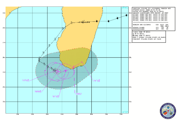
Image credit: TW
Tropical Cyclone Giovanna has strengthened at sea after wreaking havoc across Madagascar. It continues to spin-off the southwestern coast of Madagascar and forecast track are being remodeled right now. There is high risk for locally damaging winds and flooding rain through the weekend. Earlier this week, Giovanna made landfall near Tomasina with strong winds above 200 kmh (125 mph) roared across east-central Madagascar. According to Newstime Africa, at least 65 people are confirmed dead with over 11,000 homeless so far.
Thursday morning, EST, the center of T.C. Giovanna was located in the southern Mozambique Channel about 322 km (200 miles) southwest of Toliara, a city on the southwest shore of Madagascar. Friday morning, EST, the center of T.C. Giovanna was located in the southern Mozambique Channel, about 750 km (4665 miles) south-southwest of Antananarivo, a capital of Madagascar. Highest sustained winds were estimated to be 50 knots, or about 88 kmh (55 mph), with storm movement slow to the southeast. Southern Madagascar, in particular, will be at risk of damaging winds and flooding rain between Friday and Sunday.
Some forecasts have steered the storm to a late-week landfall in southern Mozambique. However, the Tropical Cyclone Center on Reunion called for a slow eastward movement to waters perilously near to southern Madagascar before the end of the week.

According to latest warning alert by Joint Typhoon Warning Center (JTWC), TC Giovanna is located 445 nm south-southwest of Antananarivo and is moving east-southwestward at 2 knots over the past six hours. Animated water vapor imagery clearly shows the cirrus blow off quickly streaming poleward. Giovanna should dissipate over land due to land interaction. Maximum significant wave height is 4,5 meters (15 feet).

While watching satellite images we came across some interesting observations. There is some vortex forming in Antarctic region. It could be possible that the newly formed system affected the change in TC Giovanna moving path but that is only an indication. Anyway, here are some satellite images that show the vortex system!


Commenting rules and guidelines
We value the thoughts and opinions of our readers and welcome healthy discussions on our website. In order to maintain a respectful and positive community, we ask that all commenters follow these rules.