
Magnitude 6.0 and 5.2 – South Sandwich Islands region
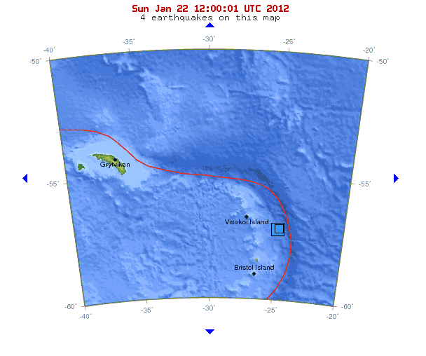
Image credit: USGS

Shalow earthquake magnitude 6.0 struck South Sandwich Islands region today at 05:53:41 UTC according to USGS. Epicenter was 138 km (85 miles) E of Visokoi Island and 281 km (174 miles) NNE of Bristol Island, South Sandwich Islands (56.670°S, 25.018°W) at depth of 9.8 km (6.1 miles). About 7 minutes later another earthquake struck same region of South Sandwich Islands.
South Georgia and the South Sandwich Islands (SGSSI) is a British overseas territory and overseas territory of the European Union in the southern Atlantic Ocean. It is a remote and inhospitable collection of islands, consisting of South Georgia and a chain of smaller islands, known as the South Sandwich Islands. South Georgia is 167.4 kilometres (104 mi) long and 1.4 to 37 km (0.9 to 23.0 miles) wide and is by far the largest island in the territory. The South Sandwich Islands lie about 520 kilometres (320 mi) southeast of South Georgia. The total land area of the territory is 3,903 square kilometres (1,507 sq mi).
South Sandwich Islands. 6.0 and 5.3 earthquake on Jan 22 2012. Image credit: USGSThere is no native population on the islands; the present inhabitants are the British Government Officer, Deputy Postmaster, scientists, and support staff from the British Antarctic Survey who maintain scientific bases at Bird Island and at the capital, King Edward Point, as well as museum staff at nearby Grytviken.
| Magnitude | 6.0 |
|---|---|
| Date-Time |
|
| Location | 56.670°S, 25.018°W |
| Depth | 9.8 km (6.1 miles) |
| Region | SOUTH SANDWICH ISLANDS REGION |
| Distances | 138 km (85 miles) E of Visokoi Island, South Sandwich Islands 281 km (174 miles) NNE of Bristol Island, South Sandwich Islands 2195 km (1363 miles) ESE of STANLEY, Falkland Islands 3532 km (2194 miles) SE of BUENOS AIRES, D.F., Argentina |
| Location Uncertainty | horizontal +/- 17.2 km (10.7 miles); depth +/- 5.7 km (3.5 miles) |
| Parameters | NST= 41, Nph=158, Dmin=777 km, Rmss=0.7 sec, Gp= 68°, M-type=teleseismic moment magnitude (Mw), Version=7 |
| Source |
|
| Magnitude | 5.2 |
|---|---|
| Date-Time |
|
| Location | 56.648°S, 24.926°W |
| Depth | 35 km (21.7 miles) |
| Region | SOUTH SANDWICH ISLANDS REGION |
| Distances | 139 km (86 miles) E of Visokoi Island, South Sandwich Islands 281 km (174 miles) NNE of Bristol Island, South Sandwich Islands 2195 km (1363 miles) ESE of STANLEY, Falkland Islands 3533 km (2195 miles) SE of BUENOS AIRES, D.F., Argentina |
| Location Uncertainty | horizontal +/- 20 km (12.4 miles); depth +/- 2.9 km (1.8 miles) |
| Parameters | NST= 39, Nph= 39, Dmin=778.1 km, Rmss=0.64 sec, Gp= 68°, M-type=body wave magnitude (Mb), Version=5 |
| Source |
|
Earthquake magnitude and location source: USGS
Commenting rules and guidelines
We value the thoughts and opinions of our readers and welcome healthy discussions on our website. In order to maintain a respectful and positive community, we ask that all commenters follow these rules.