
Hurricane Philippe Forms In The Atlantic, weakening into tropical storm
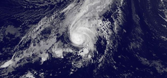
Image credit: TW
Philippe is the sixteenth named storm of the 2011 Atlantic hurricane season, following Hurricane Ophelia which brought strong winds to Ireland and Britain on Thursday. Hurricane Philippe is expected to weaken and become post-tropical during the weekend as it travels northeast across the Atlantic toward Iceland.
Philippe first formed as a tropical depression south of Cape Verde on September 24, 2011, and strengthened into a tropical storm the same day. Philippe became a hurricane on Thursday (October 6). As of 10:00 a.m. GMT on Friday, Philippe packed winds of 90 miles (150 kilometres) per hour, and was about 535 miles (865 kilometres) east-southeast of Bermuda, the National Hurricane Center (NHC) reports.

Philippe was a category one hurricane on the Saffir-Simpson hurricane wind scale. Some gradual weakening should begin today, and Philippe is forecast to become post-tropical in a day or two.
According to figures released last month, NOAA’s Climate Prediction Center is expecting an above-normal hurricane season in the Atlantic this year. The outlook calls for 14 to 19 named storms, with seven to ten becoming hurricanes and three to five expected to become a major hurricane (category 3 or higher).
An average Atlantic hurricane season produces 11 named storms, with six becoming hurricanes and two becoming major hurricanes. The Atlantic hurricane season runs from June 1 through November 30, with peak activity in September. (IWO)
Tropical Storm PHILIPPE Public Advisory Number 56
Location: 30.7°N 52.6°W
Max sustained: 70 mph
Moving: ENE at 16 mph
Min pressure: 989 mb

| …PHILIPPE ACCELERATING EAST-NORTHEASTWARD OVER THE CENTRAL ATLANTIC… | |||||||
| 11:00 PM AST Fri Oct 7 Location: 30.7°N 52.6°W Max sustained: 70 mph Moving: ENE at 16 mph Min pressure: 989 mb | Public Advisory #56 1100 PM AST | Aviso Publico none issued in last 12 hrs | Forecast/ Advisory #56 0300 UTC | Forecast Discussion #56 1100 PM AST | Wind Speed Probabilities #56 0300 UTC | ||
Tropical Storm PHILIPPE Forecast Track Guidance (SFWMD)

Satellite Animations
- Storm-Centered Infrared (GOES 12; NOAA/SSD)
- Storm-Centered Infrared (Aviation Color Enhancement) (GOES 12; NOAA/SSD)
- Storm-Centered Water Vapor (GOES 12; NOAA/SSD)
- Storm-Centered Visible (GOES 12; NOAA/SSD)
- Storm-Centered Visible (Colorized) (GOES 12; NOAA/SSD)
- Northwest Atlantic Infrared (GOES 12; NOAA/SSD)
- Northwest Atlantic Infrared (Aviation Color Enhancement) (GOES 12; NOAA/SSD)
- Northwest Atlantic Water Vapor (GOES 12; NOAA/SSD)
- Northwest Atlantic Visible (GOES 12; NOAA/SSD)
- Northwest Atlantic Visible (Colorized) (GOES 12; NOAA/SSD)
Commenting rules and guidelines
We value the thoughts and opinions of our readers and welcome healthy discussions on our website. In order to maintain a respectful and positive community, we ask that all commenters follow these rules.