
US 2011 Great Flood: Morganza spillway about to open
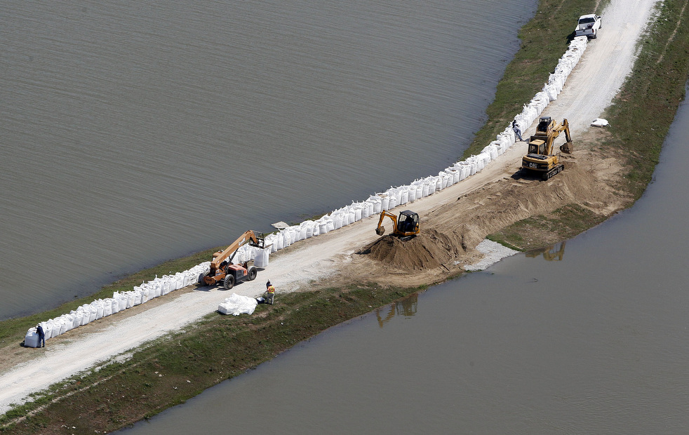
Image credit: TW
Federal officials have been given approval to open a Louisiana spillway as early as Saturday to avert a Mississippi River disaster in places like Baton Rouge and New Orleans. Army Corps of Engineers had received permission to open the Morganza spillway for the first time in 38 years to relieve pressure on river levees. The corps says it will open the spillway when the river flow reaches a certain point, but an exact timing wasn’t known. However, that flow rate is expected to happen Saturday.
Sheriffs and National Guardsmen will warn people in a door-to-door sweep through the area. In addition to the 2,500 people living inside the spillway, there are 22,500 people and 11,000 structures in the backwater areas that could be flooded. If the spillway had remained closed and the levees had failed, New Orleans could have been under as much as 20 feet of water.

The state will begin closing impacted roads and restrict public access to some levees in order to protect the public from dangerous conditions. When the U.S. Army Corps of Engineers opens the Morganza Spillway, the Louisiana Department of Transportation and Development will close the three-mile segment of La. 1 that crosses the Spillway and assist in the inspection of the structure, the state said.
Opening the Morganza spillway will ease the pressure on levees that protect Baton Rouge, New Orleans and the many oil refineries and chemical plants along the lower reaches of the river. Shelters are ready to accept up to 4,800 evacuees. If Morganza is opened, water would flow 20 miles south into the Atchafalaya River. From there it would roll on to the Gulf of Mexico, flooding swamps and croplands. Morgan City, a community of 12,000, shored up levees as a precaution.
The river’s rise may also force the closing of the river to shipping, from Baton Rouge to the mouth of the Mississippi, as early as next week. That would cause grain barges from the heartland to stack up along with other commodities. If the portion is closed, the U.S. economy could lose hundreds of millions of dollars a day. In 2008, a 100-mile stretch of the river was closed for six days after a tugboat collided with a tanker, spilling about 500,000 gallons of fuel. The Port of New Orleans estimated the shutdown cost the economy up to $275 million a day.
With crop prices soaring, farmers along the lower Mississippi River had been expecting a big year, maybe even a huge one. Now, many are facing ruin, with floodwaters swallowing up corn, cotton, rice and soybean fields.
And even more farmland will be drowned when the spillway is opened. Unlocking the spillway would inundate Louisiana Cajun country with as much as 25 feet of water but would ease the pressure on levees downstream, averting a potentially bigger disaster in New Orleans and Baton Rouge.
Cotton prices are up 86 percent from a year ago, and corn — which is feed for livestock, a major ingredient in cereals and soft drinks, and the raw material used to produce ethanol — is up 80 percent. Soybeans have risen 39 percent. The increase is attributed, in part, to worldwide demand, crop-damaging weather elsewhere and rising production of ethanol.
While the Mississippi River flooding has not had any immediate impact on prices in the supermarket, the long-term effects are still unknown. A full damage assessment can’t be made until the water has receded in many places. Some of the estimates have been dire, though.

More than 1,500 square miles of farmland in Arkansas, which produces about half of the nation’s rice, have been swamped over the past few weeks. In Missouri, where a levee was intentionally blown open to ease the flood threat in the town of Cairo, Ill., more than 200 square miles of croplands were submerged, damage that will probably exceed $100 million. More than 2,100 square miles could flood in Mississippi.
When the water level goes down — and that could take many weeks in some places — farmers can expect to find the soil washed away or their fields covered with sand. Some will probably replant on the soggy soil, but they will be behind their normal growing schedule, which could hurt yields.
For about the last six months, some parts of Louisiana and Mississippi have been battling unusually dry weather. Now they’re getting drenched with water. (TheWeatherChannel)


As flood waters continued to surge through the Mississippi River watershed in May 2011, the U.S. Army Corps of Engineers weighed whether to open spill gates onto the Morganza Floodway. The floodway, designed to reduce water levels in the Mississippi during emergencies, was last open from April 19 to June 13, 1973, the only time it has ever been opened.
The top image shows water flowing through the floodway on May 5, 1973, as observed by Landsat 1. The bottom image from Landsat 2 shows the same area in 1977 without flooding. The images include near-infrared, red, and green wavelengths of light. Vegetation appears red, muddy water is greenish brown, clear water is blue-black, and bare soil is gray to tan. In the 1973 image, red areas within the floodway may include vegetation (red) tall enough to stand above the flood water.
The floodway lies on the west side of the Mississippi, about 35 miles (56 kilometers) north of Baton Rouge, Louisiana. It averages five miles (8 kilometers) in width and stretches 20 miles (32 kilometers) to the southwest. Completed in 1954, the flood control structure, or spillway, was built to relieve stress on levees further downstream by diverting excess water from the river into the Atchafalaya River Basin.

According to the Army Corps of Engineers, the spillway was designed to maintain a Mississippi River flow rate of no greater than 1.5 million cubic feet per second at Red River Landing. The spillway is roughly 4,000 feet (1,219 meters) long, includes 125 gated openings, and has the capacity to move roughly 600,000 cubic feet of flood water per second.
The Army Corps notes on its web site: “The decision to open the Morganza Floodway relies on current and projected river flows and levee conditions, river currents and potential effects on navigation and revetments, extended rain and stage forecasts, and the duration of high river stages. When river flows at the Red River Landing are predicted to reach 1.5 million cubic feet per second and rising, the Corps considers opening the Morganza Floodway.” At 7 a.m. Central Daylight Time on May 13, 2011, the Army Corps estimated flow rates were 1.449 million cubic feet per second.
The Mississippi River has the third largest drainage basin in the world., behind only the Congo and the Amazon. It drains 41 percent of the 48 contiguous United States, including all or part of 31 states and two Canadian provinces. Extreme floods along the Mississippi in 1927 floods led the U.S. Congress to pass to the Flood Control Act of 1928, authorizing construction of levees, floodways, and other landscape modifications to control the flow of the Mississippi River. (EO)

See inundation map: Impact of opening Morganza Spillway (Large PDF file)
US Army Corps of Engineering Team New Orleans – Morganza Floodway

Built in 1954, the control structure and floodway have only been put into action once, during the 1973 flood. Unlike the Bonnet Carre, the decision to open the Morganza Spillway is complicated by its impact on populated areas of the Atchafalaya River Basin. According to a U.S. Army Corps inundation map, various towns and rural areas normally dry would be inundated by at least 5 feet of water upon opening the Morganza Spillway!
At full capacity, the Morganza spillway would divert about 600,000 cubic feet per second from the Mississippi River to the Atchafalaya River Basin. This is over twice the capacity of the Bonnet Carre Spillway upstream from New Orleans, as you can see in the original U.S. Army Corps design from 1958 below. The Morganza floodway is boxed red, while the Bonnet Carre Spillway is boxed yellow.

This is clearly one of the toughest decisions made by the U.S. Army Corps of Engineers. If you don’t open the spillway…
 You will still have river flooding along the Atchafalaya River, just not nearly as expansive.
- You risk putting undue pressure on the Old River Control Structure, which may get overwhelmed.
- This would cause the catastrophic “jumping” of the Mississippi River to the Atchafalaya River Basin, as described earlier.
- Pressure on levees in Baton Rouge and New Orleans would remain high, if the Old River Control Structure does not fail.

However, if you do open the spillway…
- There will be widespread inundation of the Atchafalaya Basin.
- Areas outside of levee protection would be under at least 5 feet of water.
- Pressure on levees in Baton Rouge and New Orleans would be lower.
Sadly, the choice here may be to open the Morganza floodway, flooding the Atchafalaya Basin to avoid the potential of a more catastrophic re-routing of the Mississippi River.
Louisiana Governor Bobby Jindal put the risk very simply:
Watch video: Diversion channels relieve flooding?
Governor Jindal also pointed out that it’s not just height of the water but also the duration. The crest could last 7-10 days, with high water lingering for weeks. (TWC)
…
more info: http://en.wikipedia.org/wiki/Morganza_Spillway
Jan Bear commented on The Watchers:
What would be the upstream effects if the Mississippi catastrophically jumped to the Atchafalaya, not in a flood situation, but as a result of, say, a terrorist attack?
My guess would be a lowering of the water level all the way upstream. Right? Sort of like a bathtub draining, as the south Louisiana lowlands allow a much larger egress of water that forces a new balance to be achieved with the incoming water upstream?
В США открыли плотину на Миссисипи, чтобы избежать затопления городов | Всё не просто так commented on The Watchers:
[…] Источник: РИА Новости, Associated Press, The Wathers […]