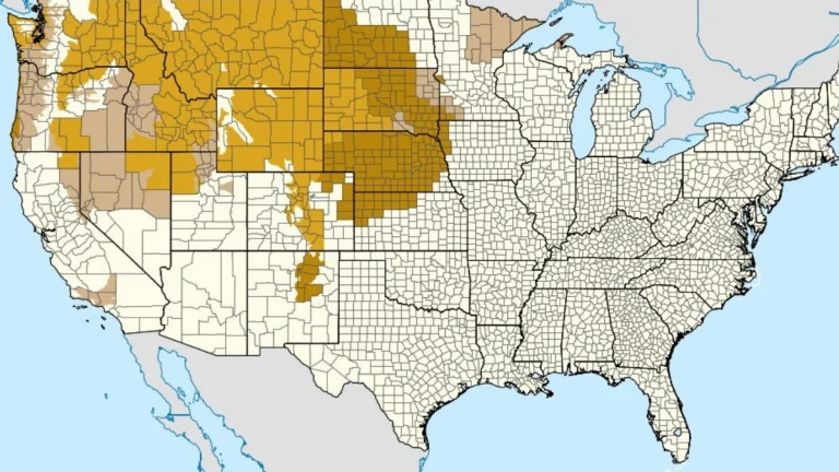
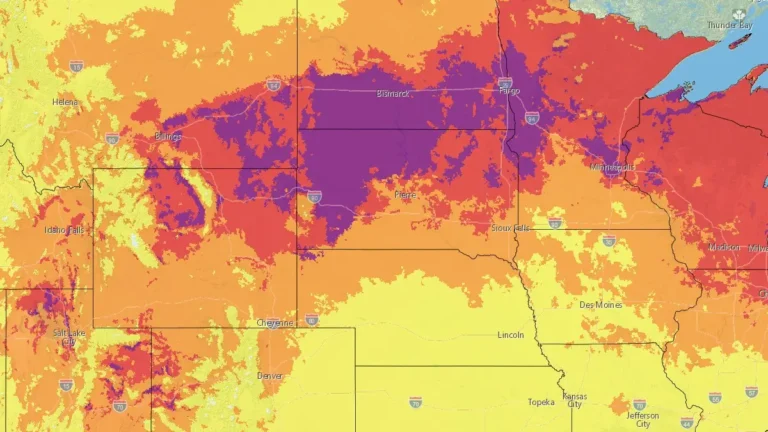
• Late-season snowstorm shuts down I-80 in southern Wyoming

    A late-season winter storm brought heavy snow and hazardous travel conditions to southern Wyoming on May 18, 2026, shutting down sections of Interstate 80 and other roads. The National Weather Service (NWS) office in Cheyenne issued winter storm and blizzard warnings for parts of Carbon and Albany counties, while the Wyoming Department of Transportation (WYDOT) reported road closures, reduced visibility, and winter travel hazards across affected corridors.

  • Heavy ice, sleet, and snow forecast across Upper Midwest and Great Lakes, multiple warnings and advisories issued

    A late-season winter storm is forecast to impact the Upper Midwest and Great Lakes region from late April 1 through April 3, 2026, bringing widespread freezing rain, sleet, and snow across multiple states. Ice Storm Warnings, Winter Storm Warnings, Winter Weather Advisories, and Winter Storm Watches are in effect, with ice accumulations up to 10 mm (0.4 inches) and snowfall exceeding 45 cm (18 inches) in some areas, creating hazardous travel conditions and potential power outages.

  • Red Flag Warnings issued from the Plains to the Southeast under critical fire weather conditions

    Red Flag Warnings are in effect across the Central Plains and Southeast United States on March 28, 2026, as the National Weather Service (NWS) warns of critical fire weather conditions driven by strong winds, low relative humidity, and dry fuels. Wind gusts up to 80 km/h (50 mph) and humidity levels as low as 10–20% are expected to promote rapid fire ignition and spread. Outdoor burning is strongly discouraged across all warned regions.

  • Winter Storm Warnings remain in effect from Idaho and Montana to the Upper Midwest

    Winter Storm Warnings remained in effect across parts of Montana, Idaho, Wisconsin, Michigan, Minnesota, and Wyoming on Friday, March 13, 2026, as a broad winter storm brought heavy snow, blowing snow, and hazardous travel conditions from the northern Rockies into the Upper Midwest. Forecast totals ranged from several cm in some lower elevations to 150 cm (5 feet) in parts of Idaho’s higher terrain, while parts of Montana’s mountain ranges were forecast to receive up to 120 cm (4 feet).

  • Winter storm warnings in effect across Great Lakes and Northeast U.S.

    Heavy snow and strong winds continue across the Great Lakes and Northeast U.S. on January 19, 2026, with winter storm warnings and advisories in effect across the region. Snow accumulations are forecast to reach 15–-35 cm (6–14 inches) in Michigan and up to 120 cm (4 feet) in parts of northern New York.

  • Red Flag Warning and High Wind Watches issued across central U.S. as strong northwesterly winds develop

    Strong northwesterly winds and very low humidity will bring critical fire weather conditions across eastern Colorado and western Kansas on Thursday, January 15, 2026, prompting the National Weather Service in Goodland to issue a Red Flag Warning and Fire Weather Watch. At the same time, high wind watches have been issued across the northern and central Great Plains, with gusts up to 120 km/h (75 mph) expected Thursday through Friday, January 16.

  • High Wind Warnings issued for the Rockies, Plains, and Pacific Northwest, U.S.

    High Wind Warnings have been issued across much of the western and central United States, effective from early Wednesday, December 17, 2025, through Thursday morning, December 18. Forecasts indicate a rapidly deepening low-pressure system developing east of the Canadian Rockies, producing winds of over 130 km/h (80 mph) in some areas. Power outages, tree damage, and hazardous travel conditions are expected from the Intermountain West to the Great Plains.

  • High wind warnings and watches issued for parts of Montana, Wyoming, Idaho, Washington, and Oregon

    The National Weather Service (NWS) issued multiple high wind warnings and watches across the Pacific Northwest and northern Rockies on Monday, December 15, 2025, as a strong surface low-pressure system moved into the region. The alerts cover parts of Montana, Wyoming, Idaho, Washington, and Oregon, and remain in effect through Wednesday afternoon, December 17, with sustained winds of 40–70 km/h (25–45 mph) and gusts exceeding 110 km/h (70 mph) forecast in exposed and mountainous areas.