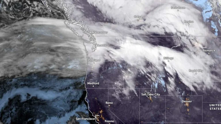
• Cross-country storm to bring heavy rain to the South and snow to the West and Great Lakes

    An atmospheric river affecting California on February 11, 2026, is forecast to evolve into a cross-country storm moving across the southern U.S. through February 13–14, 2026. Widespread rainfall totals of 25 to 75 mm (1–3 inches), with locally higher amounts, are possible across Texas to Georgia. Heavy snow is ongoing in the Sierra Nevada, with additional accumulations expected in the Wasatch and central Rockies.

  • Wind chills to −57°C (−70°F) as Extreme Cold and Blizzard Warnings continue across Alaska

    Extreme Cold Warnings and Blizzard Warnings remain in effect across northern and western Alaska on February 11, 2026, with the National Weather Service forecasting wind chills as low as −57°C (−70°F) along the Arctic Coast and Brooks Range and wind gusts up to 105 km/h (65 mph) on St. Lawrence Island. Air temperatures near −46°C (−50°F) combined with increasing winds are expected to intensify frostbite risk across the North Slope, while snowfall of 7–15 cm (3–6 inches) and visibility reductions to 400 m (0.25 miles) or less are forecast in parts of western Alaska through early February 12.

  • Watertown drops to -38°C (-36°F) as Arctic air grips Upstate New York

    An intense Arctic cold outbreak drove temperatures well below seasonal norms across Upstate New York on Sunday, February 8, 2026, with Watertown reaching −38°C (−36°F) at the airport. Several other communities matched or exceeded their lowest temperatures of the winter during the same period.

  • Beneficial Sierra Nevada snowfall expected as weak atmospheric river moves through California

    A short-duration atmospheric river is forecast to impact California from Tuesday, February 10, through Thursday, February 12, 2026, bringing low-elevation rainfall and significant snowfall at higher elevations, particularly across the Sierra Nevada. Forecast guidance indicates the event will be short-lived, with impacts expected to be largely beneficial for regional snowpack rather than flood-producing.

  • Valentine’s Day weekend storm to bring widespread heavy rain to the southern United States

    A developing storm system is forecast to bring widespread rain and thunderstorms to the south-central and southeastern United States from Friday, February 13, 2026, through Valentine’s Day weekend, with localized flooding possible where heavier rainfall occurs. The system is expected to track eastward from the Plains into the lower Mississippi Valley and Southeast between February 13 and February 15, affecting travel and outdoor activities across a large portion of the region.

  • Major storm hits Hawaii with damaging winds and extreme rainfall, causing widespread power outages

    A powerful storm system impacted Hawaii between February 8 and 10, 2026, producing heavy rainfall, flash flooding, landslides, and damaging winds. Wind gusts frequently exceeded 95 km/h (60 mph), with localized gusts approaching 115 km/h (70 mph), leading to road closures, including along Maui’s Hāna Highway, downed trees, and intermittent power outages affecting tens of thousands of customers on Oʻahu, Maui, and Hawaiʻi Island.

  • Cascades snowpack remains below 50 percent following late January storms

    Four atmospheric rivers affected the Pacific Northwest between January 27 and February 1, 2026, producing 150–300 mm (6–12 inches) of rain in the Olympic Mountains and 100–200 mm (4–8 inches) in the North Cascades. Snowfall reached up to 900 mm (36 inches) in high elevations near Mount Rainier, while snowpack remains below 50% of normal.