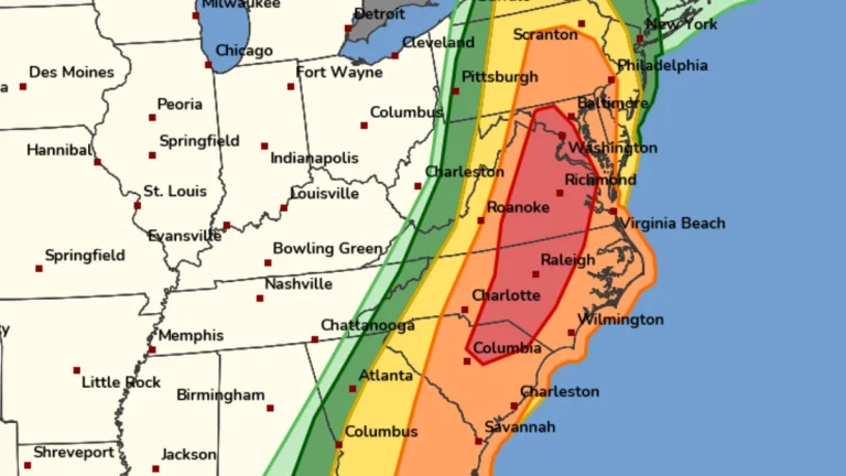
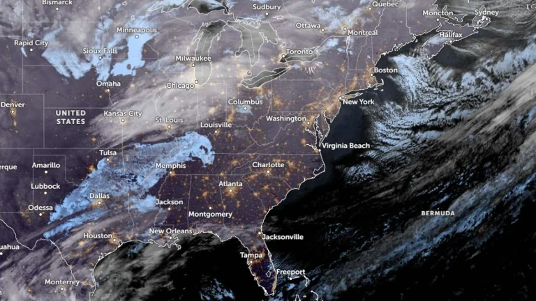
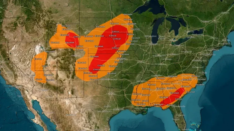
• Red Flag Warnings issued from the Plains to the Southeast under critical fire weather conditions

    Red Flag Warnings are in effect across the Central Plains and Southeast United States on March 28, 2026, as the National Weather Service (NWS) warns of critical fire weather conditions driven by strong winds, low relative humidity, and dry fuels. Wind gusts up to 80 km/h (50 mph) and humidity levels as low as 10–20% are expected to promote rapid fire ignition and spread. Outdoor burning is strongly discouraged across all warned regions.

  • Rare Moderate Risk (4/5) issued for Mid-Atlantic as severe thunderstorms raise threat of damaging winds and tornadoes

    A Moderate Risk (Level 4 of 5) for severe thunderstorms has been issued across parts of the Mid-Atlantic United States for Monday, March 16, 2026, as a powerful multi-hazard storm threatens over 100 million people across the U.S. Fast-moving storms capable of producing damaging winds and a few strong tornadoes are forecast to develop from the Carolinas into Virginia and Maryland during the afternoon and evening hours. A Moderate Risk is an unusually high severe weather category for the Mid-Atlantic and is not issued often for this region. The National Weather Service office serving the Washington, D.C. area described the setup as a “quite rare Day 2 Moderate Risk area” ahead of the event.

  • Heavy rainfall and severe storms forecast from Texas to the Carolinas this Valentine’s weekend

    A storm moving from the Southern Plains into the Southeast will generate widespread showers, locally heavy rainfall, and severe thunderstorms across the southern and eastern United States through February 16, 2026. Slight Risk areas for Severe Thunderstorms and Excessive Rainfall extend from east Texas into the lower Mississippi Valley, with additional Marginal Risk areas across the Southeast and Mid-Atlantic.

  • Rapidly intensifying coastal storm brings heavy snow and Arctic cold to the Carolinas and mid-Atlantic

    A powerful winter storm underwent rapid intensification along the East Coast from January 30 to February 1, 2026, bringing historic snow to the Carolinas and deep winter cold across much of the eastern United States. The nor’easter disrupted travel, caused power outages, and extended freezing conditions into Georgia and Alabama.

  • NWS increases confidence in heavy snow across the Carolinas and southern Virginia as Arctic air deepens

    A surge of Arctic air will spread across the central and eastern United States from Friday, January 30, 2026, bringing the longest duration of cold in several decades to parts of the region. Forecast confidence has increased for a winter storm to develop along the East Coast over the weekend, with the highest likelihood of heavy snowfall across the Carolinas and southern Virginia, and gusty coastal winds extending into the Mid-Atlantic.