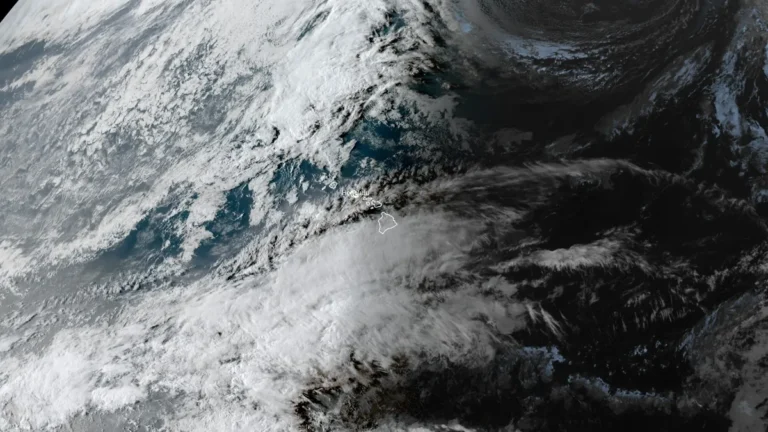
• Enhanced Risk of severe storms with supercells capable of strong tornadoes across southern Illinois and Indiana

    Severe thunderstorms capable of producing tornadoes, large hail, and damaging wind gusts are forecast across parts of the Midwest and lower Ohio Valley on February 19, 2026, with an Enhanced Risk in place for southern Illinois and southern Indiana. The Storm Prediction Center warns that a few tornadoes may be strong, particularly near and south of the I-70 corridor during the afternoon and early evening.

  • Ranger Road Fire doubles in size in one day, reaching over 114 650 ha (283 000 acres) in Kansas-Oklahoma

    The Ranger Road Fire nearly doubled in size from 58 700 ha (145 000 acres) to over 114 650 ha (283 000 acres) within roughly 24 hours after ignition at 11:40 LT on February 17, 2026, when it crossed the Kansas–Oklahoma border. As of February 18, containment stood at 15% following rapid expansion driven by dry fuels and high winds. Authorities closed sections of Kansas highways 283, 160, and 183.

  • Atmospheric river forecast to bring another round of heavy precipitation to California

    Atmospheric river associated with a slow-moving low-pressure system is forecast to impact California between February 21 and 26, 2026, bringing another round of heavy precipitation to the state. The Center for Western Weather and Water Extremes (CW3E) indicates very high confidence (>90%) in atmospheric river conditions along northern California through February 23, with moderate-to-high confidence of the AR conditions shifting south along the coast by February 24.

  • Rapid overnight growth pushes Ranger Road Fire across Oklahoma–Kansas border, 4 firefighters injured

    A fast-moving Ranger Road Fire ignited on February 17, 2026, in Beaver County, Oklahoma, and expanded into southern Kansas by February 18, burning approximately 58 700 ha (145 000 acres) within hours. The wildfire prompted mandatory evacuations in Clark County, Kansas, and injured at least four firefighters during suppression efforts.

  • Extreme and Critical fire weather trigger widespread Red Flag Warnings across Plains and Front Range

    Extremely critical fire weather conditions developed across parts of eastern Colorado, western Kansas, and the Texas and Oklahoma Panhandles on February 17, 2026, as a strengthening storm system produced very strong winds and exceptionally low humidity. Wind gusts locally exceeded 95 km/h (60 mph), while afternoon relative humidity values fell into the single digits. The Storm Prediction Center issued an Extremely Critical Fire Weather Outlook, and multiple National Weather Service offices posted Red Flag Warnings, including Particularly Dangerous Situation designations in some counties.

  • Tropical Cyclone Gezani leaves at least 63 dead across Madagascar and Mozambique

    Tropical Cyclone Gezani has left at least 63 people dead across Madagascar and Mozambique after striking eastern Madagascar on February 10, 2026, and later passing 15 km (9 miles) offshore from Mozambique’s Inhambane coast before weakening over the Mozambique Channel. Madagascar’s disaster management authority reports 59 fatalities, 15 missing persons, and 804 injured, with 423 986 people affected nationwide, while Mozambique officials confirmed four deaths and continued infrastructure disruption. Heavy rain and coastal hazards persisted into February 17 as the system looped west of southern Madagascar.

  • Extreme winter storm impacts expected in Sierra Nevada as Pacific storms bring up to 2.4 m (8 feet) of snow through February 18

    Multiple storms are forecast to bring heavy snowfall to California through February 18, 2026, with snowfall rates exceeding 76 mm (3 inches) per hour in parts of the Sierra Nevada. Extreme impacts are possible across higher elevations, with travel conditions dangerous to impossible, and 1.2–2.4 m (4–8 feet) of snow forecast above pass level.

  • Red Warning issued for heavy rain across Manawatū, Rangitīkei and Ruapehu Districts, New Zealand

    New Zealand’s MetService issued a Red Warning for heavy rain covering the Manawatū, Rangitīkei, and Ruapehu Districts at 14:36 NZDT (01:36 UTC) on February 15, 2026. The highest-level alert was issued in consultation with Horizons Regional Council as a deep low-pressure system moved south along the eastern North Island, with life-threatening flooding, slips, and river surges expected overnight into February 16. A pre-emptive state of emergency has been declared for the entire Horizons Region.

  • Gezani destroys 18 800 homes, claims 40 lives in Madagascar

    At least 40 fatalities have been confirmed, and over 18 800 homes have been destroyed as of February 13, 2026, since Tropical Cyclone Gezani made landfall over Madagascar. The storm remains active and is forecast to continue intensifying through February 13 while remaining in open waters.

  • Gezani forecast to reach intense tropical cyclone strength near Mozambique coast, more than 1 million at risk

    Tropical Cyclone Gezani was located in the Mozambique Channel at 12:00 UTC on February 12, 2026, with maximum sustained winds of 120 km/h (75 mph) and is forecast to intensify to 165 km/h (105 mph) near the Mozambique coast by February 14. Gale- to hurricane-force winds, rainfall totals locally reaching 200 mm (8 inches), and high seas of 7–10 m (23–33 feet) are possible in Inhambane Province, while Sofala and Gaza provinces remain saturated from prolonged flooding that has already displaced hundreds of thousands.