
Champi briefly reaches super typhoon strength after its closest approach to Guam causes widespread outages
Typhoon Champi passed about 16 km (10 miles) south of Merizo, Guam, at 04:26 ChST on October 18 (18:26 UTC on October 17) and was upgraded to a super typhoon about three hours later. The Joint Typhoon Warning Center (JTWC) post-analysis placed its 00:00 UTC intensity at 269 km/h (167 mph) before the cyclone weakened to 222 km/h (140 mph) by 12:00 UTC, while Guam authorities reported widespread power outages and disruptions to water services.
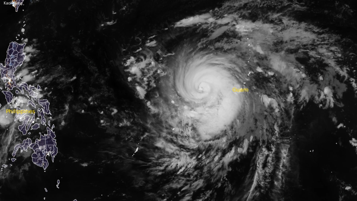
Satellite image of Typhoon Champi at 14:10 UTC on October 18, 2026. Image credit: NOAA/GOES, RAMMB/CIRA, The Watchers
The National Weather Service (NWS) in Guam said Champi’s small eyewall passed just south of the island, placing the strongest typhoon-force winds over southern Guam. Its 07:57 ChST (21:57 UTC on October 17) advisory, based on conditions at 07:00 ChST (21:00 UTC), upgraded Champi to a super typhoon with maximum sustained winds of 241 km/h (150 mph).
At 19:00 ChST (09:00 UTC), JTWC placed Super Typhoon Champi about 289 km (180 miles) west-southwest of Andersen Air Force Base. It was moving west at 22 km/h (14 mph) with maximum sustained winds of 241 km/h (150 mph). A later review of earlier data led JTWC to raise its estimate for 00:00 UTC to 269 km/h (167 mph)
JTWC said Champi’s inner core weakened after the 00:00 UTC peak as a second eyewall formed and dry air entered the storm. This happened even though surrounding conditions remained favorable, with low vertical wind shear of 19–28 km/h (12–17 mph), sea-surface temperatures of 29–30°C (84–86°F) and strong outflow high in the atmosphere.
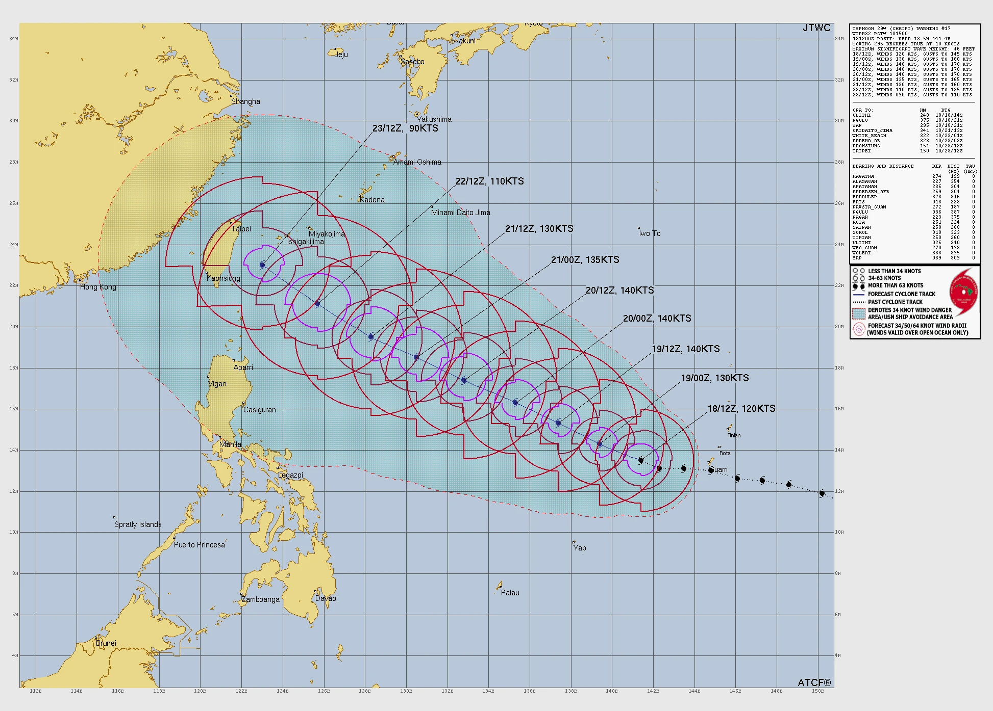
JTWC downgraded the system from a super typhoon in Warning Number 17, issued at 15:00 UTC. Champi’s center was about 346 km (215 miles) west of Naval Station Guam at the time.
The Guam Power Authority (GPA) said approximately 75% of the island still had electricity at 05:30 ChST (19:30 UTC on October 17), shortly after Champi’s closest approach. More power lines went offline as the winds shifted, reducing the powered share of the island to about 50% by 07:50 ChST (21:50 UTC).
At 09:00 ChST (23:00 UTC on October 17), GPA reported that approximately 51% of its power-distribution feeders and circuits were online. The island’s power system did not suffer a complete blackout, but outages affected many areas, especially in southern Guam.
Most transmission lines supplying northern Guam remained intact. Power remained available to Naval Base Guam, most of Hotel Row in Tumon, Guam Memorial Hospital, Harmon Industrial Park, Andersen Air Force Base, Camp Blaz and underground systems in Tumon and Tamuning.
Substations at Talofofo, Umatac, Radio Barrigada and part of Pulantat were affected.
The Guam Waterworks Authority reported 98 production wells operating at 08:00 ChST (22:00 UTC on October 17), including 72 running on standby generators. All sewer pump stations and wastewater treatment plants remained online.
The Ugum Surface Water Treatment Plant was shut down after flooding increased turbidity, or the amount of suspended material, in the Ugum River.
Parts of Pago Bay, Malesso’ and Latte Heights had low water pressure or no water service. The utility adjusted wells, pump stations and reservoirs as power failed and generators took over.
The Joint Information Center said at 08:15 ChST (22:15 UTC on October 17) that no sewer overflows had been reported.
Guam Memorial Hospital continued treating patients during the storm. Three people received storm-related emergency care, including one person with minor injuries from a wind-related fall, and all three were discharged after treatment.
The hospital reported minor water leaks and power fluctuations but no loss of power or major safety incident.

The Guam Department of Education closed all public schools on October 19 so buildings could be inspected. Several campuses continued to operate as emergency shelters, and Catholic schools were also closed.
Government teams began checking roads, public facilities, utility damage, debris and flooding across the island.
A presidential emergency declaration authorized the Federal Emergency Management Agency to coordinate federal emergency assistance. The latest Joint Information Center release, issued at 12:45 ChST (02:45 UTC), kept Guam under Condition of Readiness 1 while hazardous conditions continued.
A Flood Watch and Wind Advisory remained in effect for Guam through 04:00 ChST on October 19 (18:00 UTC on October 18).
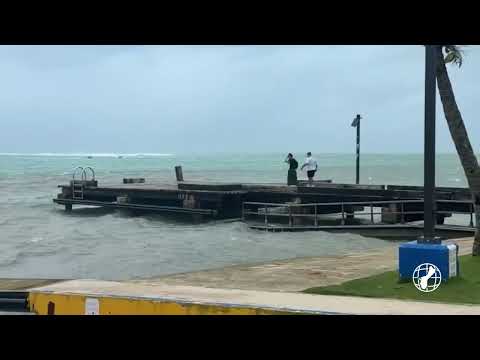
A High Surf Advisory and a high risk of rip currents remained in effect through 16:00 ChST on October 19 (06:00 UTC). A Hazardous Seas Warning covered waters around Guam and Rota through 17:00 ChST (07:00 UTC), with NWS forecasting combined seas of about 4–5 m (13–16 feet) around Guam.

JTWC forecast Champi to regain super typhoon strength. Sustained winds were forecast to increase to 241 km/h (150 mph) by 00:00 UTC on October 19 and 259 km/h (161 mph) by 12:00 UTC.
The storm was forecast to move west-northwest across the Philippine Sea before gradually weakening later in the period.
JTWC’s 09:00 UTC discussion said forecast models were in close agreement for the first 72 hours but differed after that. Some showed Champi turning toward the East China Sea, while others took it more directly toward southern Taiwan. The official forecast placed the storm near 23.0°N, 123.0°E by 12:00 UTC on October 23, east of southern Taiwan.
Reference:
1 Typhoon 29W (Champi), Warning Number 17 – JTWC – October 18, 2026,
2 Prognostic Reasoning for Super Typhoon 29W (Champi), Warning Number 16 – JTWC – October 18, 2026
3 JIC Release Number 14 – Guam Homeland Security/Office of Civil Defense – October 18, 2026
4 Super Typhoon Champi Advisory Number 14 – NWS Guam – October 18, 2026

Rishav Kothari is Editor-in-Chief of The Watchers, where he runs the newsroom and covers earthquakes, volcanoes, severe weather and space weather.
