
Hurricane and storm surge watches issued for northern Gulf Coast as Isaias strengthens, U.S.
Hurricane, storm surge and tropical storm watches were issued for portions of the U.S. northern Gulf Coast on Wednesday morning, October 7, 2026, as Tropical Storm Isaias strengthened over the Gulf of America, according to the National Hurricane Center (NHC). The watches extend from the mouth of the Mississippi River eastward to Yankeetown, Florida.
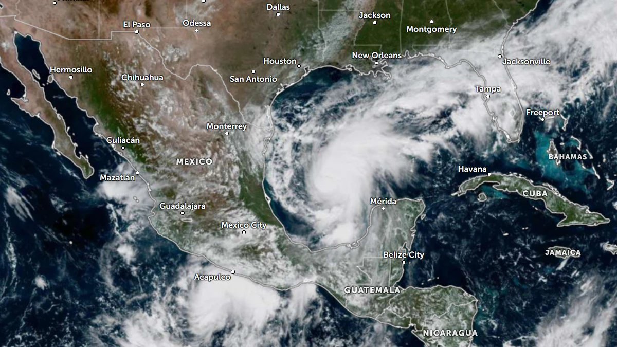
Satellite image of Tropical Storm Isaias at 17:50 UTC October 7, 2026. Credit: NOAA/GOES-19, Zoom Earth The Watchers
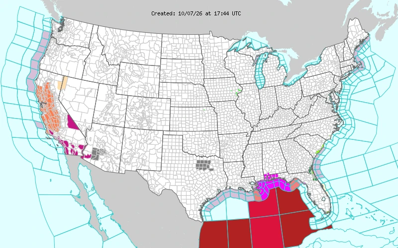
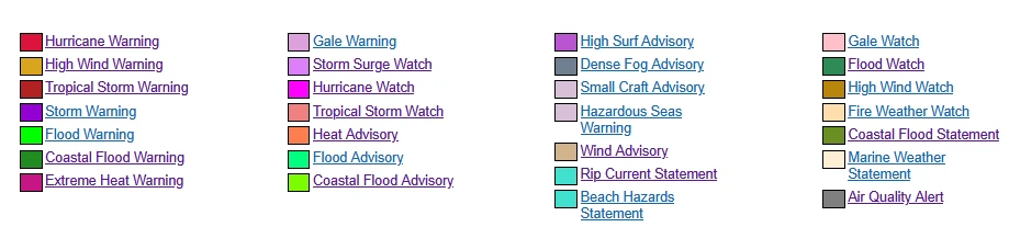
A Hurricane Watch is in effect from Bay St. Louis, Mississippi, to Indian Pass, Florida. Hurricane conditions are possible within this area beginning late Friday.
A Tropical Storm Watch is in effect from the Jefferson/Plaquemines Parish line, Louisiana, to west of Bay St. Louis, and from east of Indian Pass to the Aucilla River, Florida. Tropical storm conditions could begin in the watch areas around midday Friday.
A Storm Surge Watch is in effect from the mouth of the Mississippi River to Yankeetown. NHC said life-threatening inundation from rising water moving inland is possible within 48 hours.
If the peak surge occurs at the time of high tide, water could reach 1.5 to 2.1 m (5 to 7 feet) above ground from Ocean Springs, Mississippi to Indian Pass, Florida, and within Mobile Bay.
Surge heights of 0.9 to 1.5 m (3 to 5 feet) are possible from the mouth of the Mississippi River to Ocean Springs and from Indian Pass to the Aucilla River. Amounts of 0.6 to 1.2 m (2 to 4 feet) are possible from the Aucilla River to Yankeetown, and 0.3 to 0.9 m (1 to 3 feet) along Lake Pontchartrain.
No hurricane or tropical storm warning was in effect for any land area as of Wednesday morning. NHC said additional watches and warnings could be required for a portion of the northern Gulf Coast later Wednesday.
As of 15:00 UTC (10:00 a.m. CDT), the center of Isaias was located near 22.4°N 93.6°W by an Air Force Reserve Hurricane Hunter aircraft, about 420 km (260 miles) west-northwest of Progreso, Mexico, and 870 km (540 miles) south-southwest of the mouth of the Mississippi River.
Maximum sustained winds were near 75 km/h (45 mph), and the minimum central pressure was 1 000 hPa based on dropsonde data. The storm was moving east-northeast at 13 km/h (8 mph), with tropical-storm-force winds extending up to 75 km (45 miles) from the center.
NWS Mobile said peak winds of 120 to 155 km/h (75 to 95 mph), with gusts to 185 km/h (115 mph), are possible in the Pensacola, Florida area. Winds of 89 to 113 km/h (55 to 70 mph) with gusts to 160 km/h (100 mph) are possible along the Baldwin County, Alabama coast.
A Hurricane Watch is also in effect for coastal marine waters from Pensacola to Pascagoula, where winds of 95 to 130 km/h (50 to 70 knots) and seas up to 10 m (33 feet) are possible.
NHC issued a Hurricane Warning for offshore waters of the central Gulf of America, where hurricane conditions are expected Thursday night. Winds of 120 to 155 km/h (65 to 85 knots) and seas of 5.8 to 8.8 m (19 to 29 feet) are forecast there.
Tropical storm watches cover Lake Borgne, Barataria Bay and Apalachee Bay, with a hurricane watch for St. Andrews Bay Waterways in Florida.
Local rainfall forecasts from NWS Mobile show 150 to 250 mm (6 to 10 inches) possible in coastal Baldwin, Escambia and Santa Rosa counties, and 100 to 200 mm (4 to 8 inches) in Mobile and Okaloosa counties. Major flooding rain could prompt evacuations and rescues in these areas.
Along the Mississippi coast, 50 to 150 mm (2 to 6 inches) of rain is forecast. The Florida Big Bend could receive an additional 75 to 150 mm (3 to 6 inches), with up to 200 mm (8 inches) in parts of Franklin County.
A few tornadoes are possible within portions of the watch area, according to NWS Mobile, which described the tornado situation as somewhat favorable.
The Weather Prediction Center (WPC) said tropical moisture interacting with a nearly stationary boundary will keep widespread thunderstorms over most of the Florida Peninsula and parts of the Panhandle through the next couple of days. Heavy rainfall is expected to reach the Florida Panhandle by Friday morning, with WPC collaborating with NHC on rainfall forecasts.
References:
1 Short Range Public Discussion – NWS/WPC – issued 09:10 UTC, October 7, 2026

Rishav Kothari is Editor-in-Chief of The Watchers, where he runs the newsroom and covers earthquakes, volcanoes, severe weather and space weather.
Published in the last 24 hours
- CPC posts a slight risk of heavy rain from the Gulf Coast to the Northeast urban corridor November 25-29, and a moderate risk of West Coast wind and Sierra snow on November 25
- Cyclone Akvan to make landfall between Nellore and Visakhapatnam around noon on November 20, IMD forecasts 120-130 km/h winds gusting to 145
- The storms drenching California this week are fed by a river in the sky, a band of water vapor that can carry up to 15 times the flow of the Mississippi River, and this winter’s near-record El Niño could keep aiming more of them at the West Coast
- Florida's east coast faces a moderate flash flood risk Wednesday through Friday, with 4 to 8 inches of rain forecast and the St. Johns River near Cocoa already in major flood at 17.13 feet
