
Tropical Storm Isaias forms in the Gulf of America, forecast to rapidly strengthen before U.S. landfall
Tropical Depression Nine strengthened into Tropical Storm Isaias over the Gulf of America early Wednesday, October 7, 2026, according to the National Hurricane Center (NHC). The storm is forecast to rapidly strengthen into a hurricane by Thursday and approach the U.S. northern Gulf Coast on Friday.
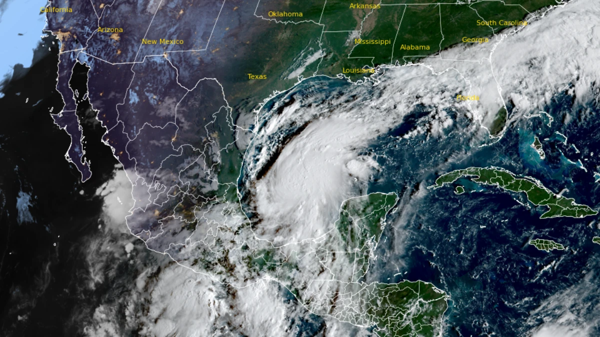
Satellite image of Tropical Storm Isaias at 13:30 UTC on October 7, 2026. Credit: NOAA/GOES-19, RAMMB/CIRA, The Watchers
- There is an increasing risk of dangerous wind and storm surge impacts along portions of the northern Gulf Coast, NHC warns. Residents from Louisiana to the Florida Panhandle should closely monitor the latest forecast updates and ensure they have their hurricane plan in place. Hurricane and Storm Surge Watches will likely be required for a portion of the northern Gulf Coast later today.
- Tropical Storm Isaias will bring areas of heavy rainfall to the central U.S. Gulf Coast and much of the Southeast Friday into the weekend. Flash and urban flooding, along with isolated river flooding, will be possible.
- Yucatan Peninsula of Mexico: Tropical Storm Isaias is expected to strengthen and could bring gusty winds and areas of heavy rain to the western portion of the Yucatan Peninsula over the next day or two.
As of 09:00 UTC Wednesday (4:00 a.m. CDT), the center of Isaias was located about 460 km (285 miles) west of Progreso, Mexico, and 935 km (580 miles) southwest of the mouth of the Mississippi River.
Maximum sustained winds were near 65 km/h (40 mph) with higher gusts, and the estimated minimum central pressure was 1 004 hPa. Tropical-storm-force winds extended up to 75 km (45 miles) from the center.
The system was moving east-northeast at 13 km/h (8 mph). NHC upgraded the depression based on satellite imagery, a nearby buoy observation, and a Dvorak classification of T2.5, with Air Force Reserve and NOAA Hurricane Hunter aircraft scheduled to sample the storm later Wednesday.


An east-northeast motion is expected Wednesday, taking the storm north of the Yucatan Peninsula on Thursday, followed by a turn toward the northeast and north on Thursday and Friday. Isaias is forecast to approach the U.S. northern Gulf Coast on Friday.
NHC said confidence in the track forecast remains below average because of significant spread among models, with AI-based guidance on the eastern side of the envelope and physics-based models on the western side. The latest track is an eastward shift from the previous advisory.
Rapid strengthening is forecast over the next day or two. Isaias is expected to become a hurricane on Thursday, with winds near 120 km/h (75 mph), and to peak near 175 km/h (110 mph), Category 2 strength, over the central Gulf on Thursday night.
Strong wind shear is expected to increase before the storm reaches the coast. NHC said it is “looking more likely” that Isaias “will be a significant hurricane when it reaches the coast,” with an expanding wind field and impacts extending far from the center on the eastern side of the storm.
The NHC forecast shows the center moving inland along the northern Gulf Coast by early Saturday, with maximum sustained winds near 140 km/h (85 mph). Isaias is then forecast to weaken rapidly inland, become post-tropical over the southeastern United States by Sunday, and dissipate by Monday.

No coastal watches or warnings were in effect as of Wednesday morning. NHC said Hurricane and Storm Surge Watches will likely be required for a portion of the northern Gulf Coast later Wednesday.
Residents from Louisiana to the Florida Panhandle were advised to closely monitor updates and ensure their hurricane plans are in place.
Rainfall of 50 to 100 mm (2 to 4 inches) is expected through Thursday along coastal portions of the Bay of Campeche, with isolated higher amounts in the Mexican states of Campeche and western Yucatan.
From Friday through the weekend, 75 to 150 mm (3 to 6 inches) of rain is forecast from far southeastern Louisiana to the Florida Panhandle, with localized totals up to 250 mm (10 inches). Amounts of 25 to 75 mm (1 to 3 inches), with localized totals up to 125 mm (5 inches), are possible across much of the Southeast as far north as the Tennessee Valley and the Carolinas.
Flash and urban flooding, along with isolated river flooding, will be possible.
Gusty winds are possible in portions of the Yucatan Peninsula on Thursday. Swells are expected to reach the western and northern Yucatan Peninsula beginning Thursday and spread north toward the Gulf Coast late this week, likely causing life-threatening surf and rip current conditions.
References:
1 Tropical Storm Isaias Public Advisory Number 3 – NOAA/NHC – October 7, 2026
2 Tropical Storm Isaias Forecast Discussion Number 3 – NOAA/NHC – October 7, 2026

I am an Assistant Editor and Severe Weather & Science Journalist at The Watchers, specializing in real-time severe weather coverage, geophysical event reporting, and research-driven scientific analysis. You can reach me at rishav(at)watchers(.)news.

There is no such place as the gulf of America.! who taught this bloke geography? Journalistic colonialism? Gulf of MEXICO if you please.
There is no such place as the ‘Gulf of America’.
I commented the same, but it was not published.
I understand in the U.S is now a rule, but not to the rest of the world.
You are right. Yes.
Gulf og America? Are we serious?