
Tropical Storm Nolo strengthens south of Hawaii, up to 890 mm (35 inches) of rain forecast
Tropical Storm Nolo strengthened south of Hawaii on September 24, 2026, as forecasters warned of potentially life-threatening flooding across Hawaii Island. At 05:00 HST (15:00 UTC), the Central Pacific Hurricane Center (CPHC) reported maximum sustained winds of 95 km/h (60 mph) and placed Nolo approximately 460 km (285 miles) south of South Point. The CPHC forecast 380–510 mm (15–20 inches) of rain across Hawaii Island, with localized totals near 890 mm (35 inches).
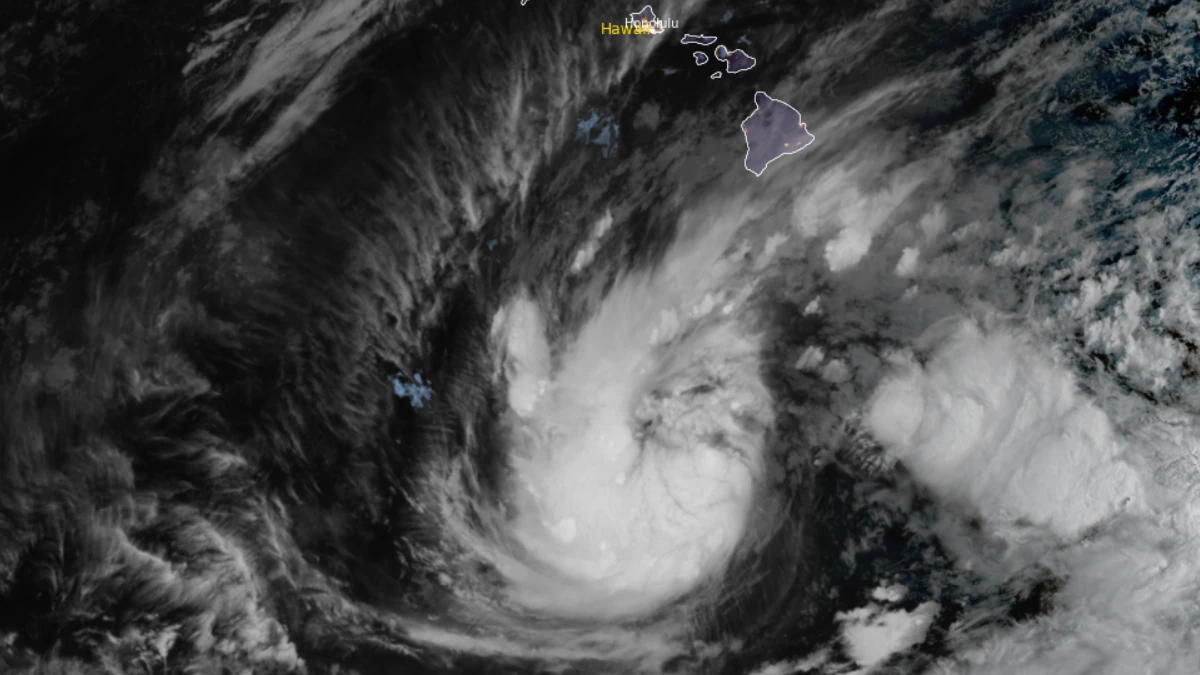
Satellite image of Tropical Storm Nolo at 16:20 UTC on September 24, 2026, Credit: NOAA/GOES-19, RAMMB/CIRA, The Watchers
Tropical Storm Nolo strengthened south of Hawaii on September 24. At 05:00 HST (15:00 UTC), the Central Pacific Hurricane Center (CPHC) reported that the storm had 1-minute sustained winds of 95 km/h (60 mph) and placed the storm approximately 460 km (285 miles) south of South Point, Hawaii.
The CPHC forecast 380–510 mm (15–20 inches) of rain across Hawaii Island, with localized totals near 890 mm (35 inches). A Hurricane Watch remained in effect for Hawaii County, while a Flood Watch covered Hawaii Island and Maui County.
Nolo was centered approximately 735 km (455 miles) south-southeast of Honolulu. The storm was stationary, and its estimated minimum central pressure was 997 hPa.
Maximum sustained winds had increased from 75 km/h (45 mph) at 03:00 UTC to 85 km/h (50 mph) at 09:00 UTC and 95 km/h (60 mph) at 15:00 UTC. Tropical-storm-force winds extended up to 150 km (90 miles) from the center.
Nolo’s rainbands were forecast to reach Hawaii Island later on September 24, with the greatest flooding threat over windward and southeastern districts and windward Maui. The CPHC warned that the rainfall could produce life-threatening flooding and mudslides, particularly in steep terrain.
An NWS Flood Watch covered Hawaii Island, Maui, Molokai, Lanai and Kahoolawe through 18:00 HST on September 26 (04:00 UTC on September 27). NWS Honolulu said significant flooding, road closures, property damage and landslides were possible.
The CPHC forecast 130–250 mm (5–10 inches) of rain across Maui, with localized totals near 510 mm (20 inches). Across the remaining Hawaiian Islands, 25–75 mm (1–3 inches) was forecast, with localized totals near 150 mm (6 inches) and isolated flooding possible.


The CPHC expected Nolo to move north or north-northeast later on September 24 through September 25, followed by a sharp westward turn by September 26 in the vicinity of Hawaii Island. Nolo was forecast to become a hurricane by the night of September 24 and could become a major hurricane during the weekend.
Track uncertainty remained higher than normal, and small changes in the storm’s course would affect the distribution of wind, rain, and coastal hazards. The Hurricane Watch means that hurricane conditions are possible within Hawaii County; it does not indicate that such conditions are occurring or certain.
Tropical-storm-force winds could begin affecting parts of Hawaii Island on September 25, with hurricane conditions possible from Friday night. The CPHC forecast possible storm-surge inundation of 0.3–0.9 m (1–3 feet) above ground in parts of Hawaii County if the peak surge coincided with high tide.
Swells generated by Nolo were expected to reach exposed east- and south-facing shores of Hawaii Island on September 25, producing life-threatening surf and rip currents. NWS Honolulu also identified the potential for tornadoes and large waterspouts over and near the island, mainly along and to the right of the forecast track.
Hawaii Governor Josh Green announced that state and county offices, public schools and University of Hawaii campuses on Hawaii Island would close on September 24 and 25. The closures were scheduled to extend to Maui County on September 25, while essential government services and emergency operations continued.
The Hawaii Department of Land and Natural Resources closed state parks, campgrounds, forest reserves, hiking trails and other managed lands on Hawaii Island from September 24. Similar closures on Maui and Molokai were scheduled to begin on September 25.
Green also requested a federal emergency declaration covering Hawaii’s four principal counties. The request sought assistance for emergency protective measures, debris removal, and direct federal support, including search and rescue, emergency power, communications, and transportation; the governor’s announcement documented a request, not federal approval.
Nolo developed from the remnants of Tropical Depression Fifteen-E, which became a remnant low on September 16 after moving westward from the eastern Pacific. The CPHC resumed advisories at 09:00 UTC on September 23 and upgraded the system to Tropical Storm Nolo at 21:00 UTC that day.
References:
1 Tropical Storm Nolo Advisory Number 16 – CPHC – September 24, 2026
2 Tropical Storm Nolo Local Statement Advisory Number 15 – NWS Honolulu – September 24, 2026
3Nolo Local Watch/Warning Statement Advisory Number 16 – NWS Honolulu – September 24, 2026
4 Office and school closure announcement – Office of the Governor: State of Hawaii – September 23, 2026
5 State land and park closures for Nolo – Hawaii Department of Land and Natural Resources – September 23, 2026

Rishav Kothari is Editor-in-Chief of The Watchers, where he runs the newsroom and covers earthquakes, volcanoes, severe weather and space weather.
