
Long-duration nor’easter brings coastal flooding to Virginia, threatens Northeast US with damaging winds and heavy rain
A long-duration nor’easter is forecast to bring coastal gusts of 70–95 km/h (45–60 mph) and periods of heavy rain to southern New England from September 25, 2026 through the weekend. High Wind Warnings are in effect for coastal and southeastern Massachusetts and most of Rhode Island. Coastal Flood Warnings remain in effect across southeastern Virginia, where the National Weather Service (NWS) forecasts 0.6–0.9 m (2–3 feet) of inundation.
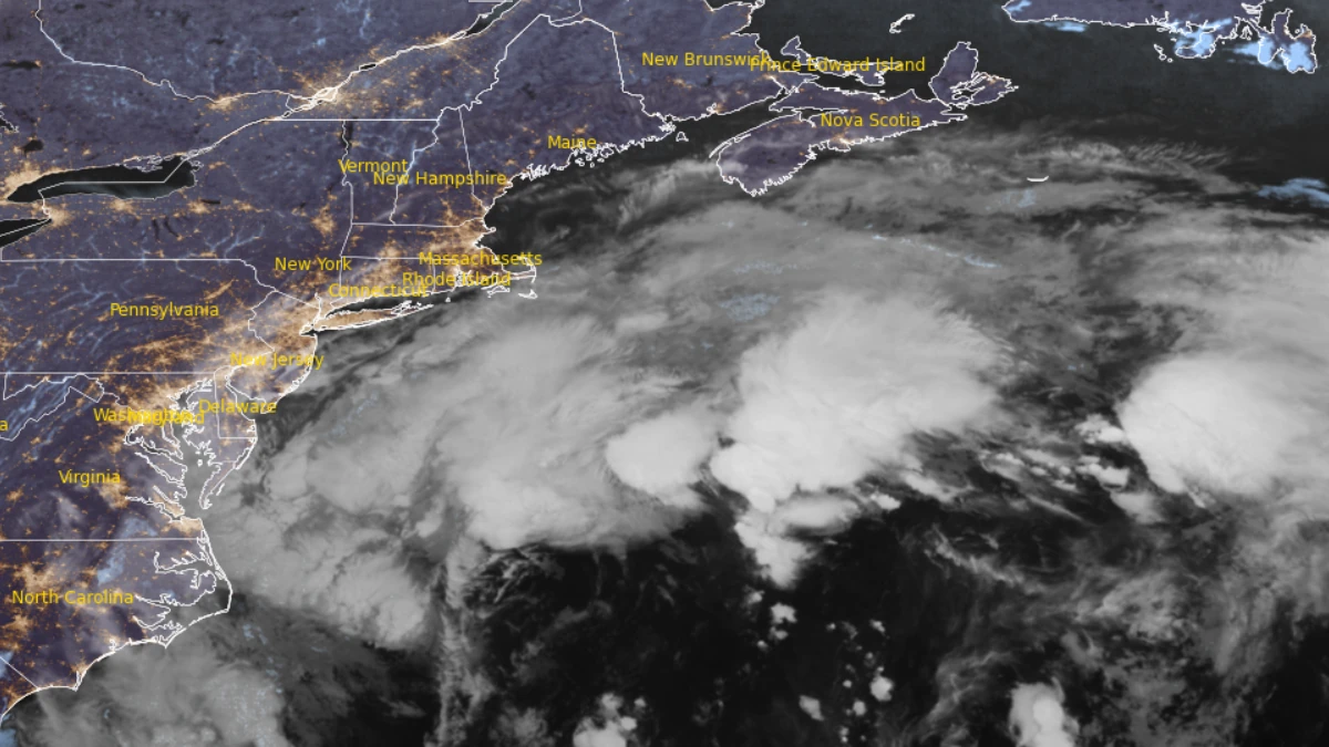
Satellite image of Northeast U.S. at 07:20 UTC on September 25, 2026. Credit: NOAA/GOES-19, RAMMB/CIRA, The Watchers
The National Weather Service (NWS) issued High Wind Warnings for coastal Massachusetts and most of Rhode Island early on September 25, as a strengthening nor’easter developed offshore of the Mid-Atlantic.
Coastal Flood Warnings remained in effect across southeastern Virginia after repeated high-tide cycles flooded roads and disrupted municipal operations in Norfolk, while heavy rain, strong winds and coastal flooding were forecast from New York to New England through the weekend.
NWS Boston/Norton placed coastal and southeastern Massachusetts and all of Rhode Island except northwestern Providence County under High Wind Warnings from 08:00 EDT (12:00 UTC) on September 25 until 02:00 EDT (06:00 UTC) on September 27. Wind Advisories covered adjacent inland areas.
Northeasterly gusts of 70–95 km/h (45–60 mph) were forecast along the southern New England coast. A few locations on the islands could receive gusts of 105–110 km/h (65–70 mph), although the NWS said this would depend on the storm track.
The prolonged winds, periods of heavy rain and fully leafed trees were expected to increase the risk of fallen trees and power outages. Rainfall totals of 25–100 mm (1–4 inches) were forecast across southern New England, with the highest amounts most likely near the coast.
Coastal Flood Watches for eastern Massachusetts, Cape Cod and the islands were extended from the afternoon of September 25 through the evening of September 27. The NWS forecast a storm surge of 0.3–0.6 m (1–2 feet), briefly near 0.8 m (2.5 feet), with minor to locally moderate flooding possible during several high-tide cycles.
Breaking waves of 2.1–4.0 m (7–13 feet) were forecast along exposed Massachusetts beaches. Offshore, Storm Warnings were issued for all waters covered by NWS Boston/Norton, where gusts of 85–110 km/h (50–70 mph) and seas of 4.6–7.6 m (15–25 feet) were forecast; those marine wind forecasts do not represent expected winds over land.
In Norfolk, Virginia, municipal officials said on September 24 that crews were responding to roadway flooding, drainage problems, waste-collection disruptions and transportation impacts. The city warned that Hampton Boulevard near Surrey Crescent and Larchmont would become impassable at high tide and identified several other roads where tidal flooding was expected.
Norfolk activated designated higher-ground parking locations for residents. The York Street Garage was made available through 08:00 EDT (12:00 UTC) on September 28, while stormwater crews continued clearing drains and flooding-related blockages.
NWS Wakefield extended the Coastal Flood Warning for Norfolk, Portsmouth, Suffolk, Chesapeake, Hampton and Poquoson until 11:00 EDT (15:00 UTC) on September 26. Inundation of 0.6–0.9 m (2–3 feet) above ground level was expected in vulnerable shoreline and tidal-waterway areas, with numerous road closures possible and homes and businesses threatened.
The office reported that widespread moderate to locally major tidal flooding was expected to continue through the night of September 25 at most locations. Some sites around the middle Chesapeake Bay could continue to experience moderate coastal flooding into September 26 or 27.
High Surf Advisories also remained in effect along the southeastern Virginia coast through 19:00 EDT (23:00 UTC) on September 25. Breaking waves of 2.4–3.7 m (8–12 feet), dangerous rip currents and localized beach or dune erosion were expected.
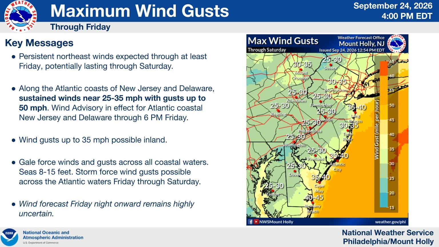
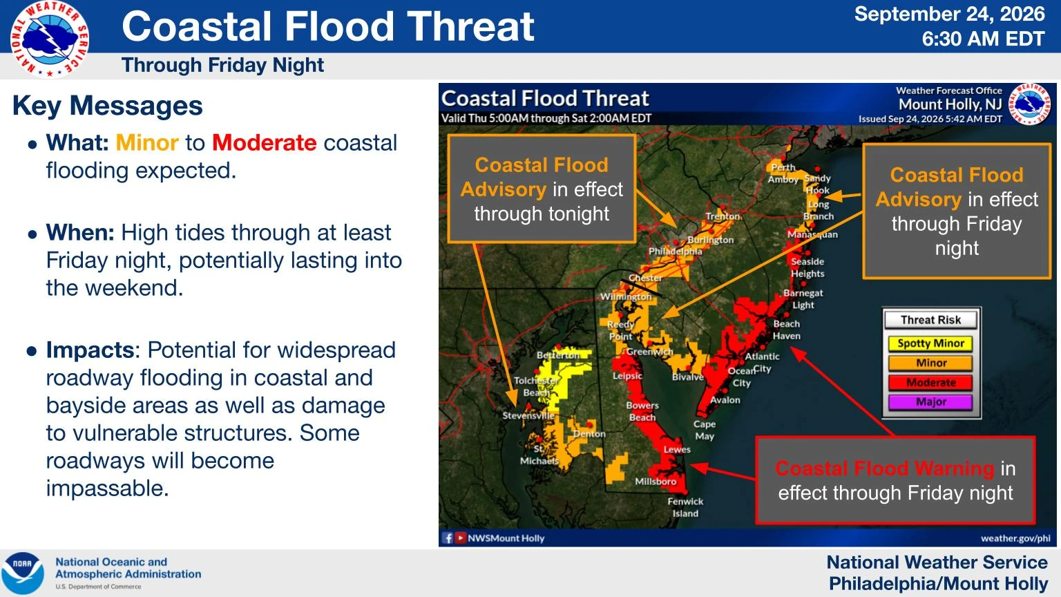
In New Jersey and Delaware, Coastal Flood Warnings were extended until 14:00 EDT (18:00 UTC) on September 26. The NWS forecast 0.3–0.6 m (1–2 feet) of inundation in low-lying shoreline and tidal-waterway areas, with widespread roadway flooding and some damage to vulnerable structures possible.
High Surf Advisories for the Jersey Shore and Delaware Beaches remained in effect through 20:00 EDT (00:00 UTC on September 27) on September 26, with breaking waves up to 3.7 m (12 feet). A High Wind Watch covered exposed coastal areas from the evening of September 25 through the afternoon of September 26, when northerly gusts up to 95 km/h (60 mph) were possible.
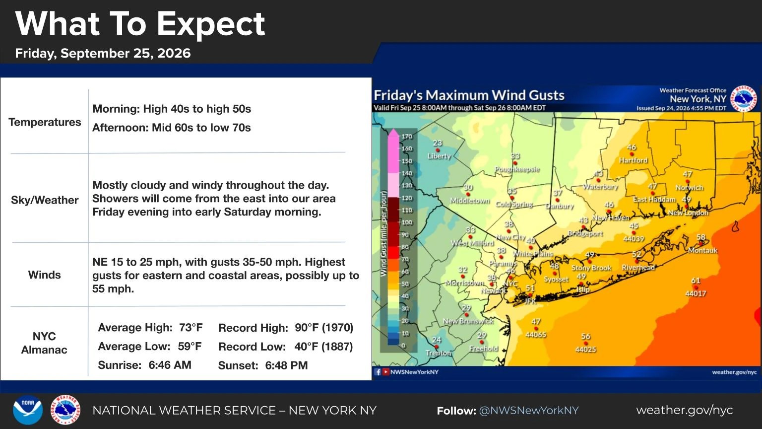
NWS New York/Upton issued a Wind Advisory for New York City, Long Island, southern Westchester County and most of southern Connecticut from 14:00 EDT (18:00 UTC) on September 25 until 06:00 EDT (10:00 UTC) on September 27. Gusts of 65–80 km/h (40–50 mph), with localized gusts near 90 km/h (55 mph), were forecast.
The office forecast 75–125 mm (3–5 inches) of rain across Long Island and southern Connecticut and 25–75 mm (1–3 inches) elsewhere in its area through the weekend. The highest-rainfall corridor remained sensitive to small changes in the storm track, and the NWS said flash-flood concerns were expected to remain localized because most of the rain would fall over 24–36 hours.
Coastal Flood Watches covered parts of New York City and Long Island for the high tides from the evening of September 25 into September 26. Moderate coastal flooding was possible, with an increasing risk of major flooding at some locations around the South Shore bays of Long Island.
The low-pressure system was strengthening offshore between a stalled frontal boundary and strong high pressure over Quebec. NWS New York/Upton forecast the center to pass near or just west of the 40°N/70°W benchmark during the night of September 25 into September 26, then move back toward the region on September 27 before gradually weakening.
Forecasters continued to report uncertainty in the precise track. A shift closer to or farther from the coast would change the locations of the strongest winds, heaviest rain and highest coastal water levels.
Reference:
1 Area Forecast Discussion – NWS Boston/Norton – September 25, 2026
2 Area Forecast Discussion – NWS New York/Upton – September 25, 2026
3 Weather Update: Coastal Flood Warning – City of Norfolk – September 24, 2026

Rishav Kothari is Editor-in-Chief of The Watchers, where he runs the newsroom and covers earthquakes, volcanoes, severe weather and space weather.
