
High Wind and Coastal flood alerts issued as nor’easter brings coastal flooding to Virginia
A strengthening nor’easter was producing coastal flooding in southeastern Virginia on September 25, 2026, while high winds, heavy rain, high surf and additional tidal flooding were forecast from New York to New England through the weekend. High Wind Warnings covered coastal Massachusetts and most of Rhode Island, with gusts of 70–95 km/h (45–60 mph) expected.
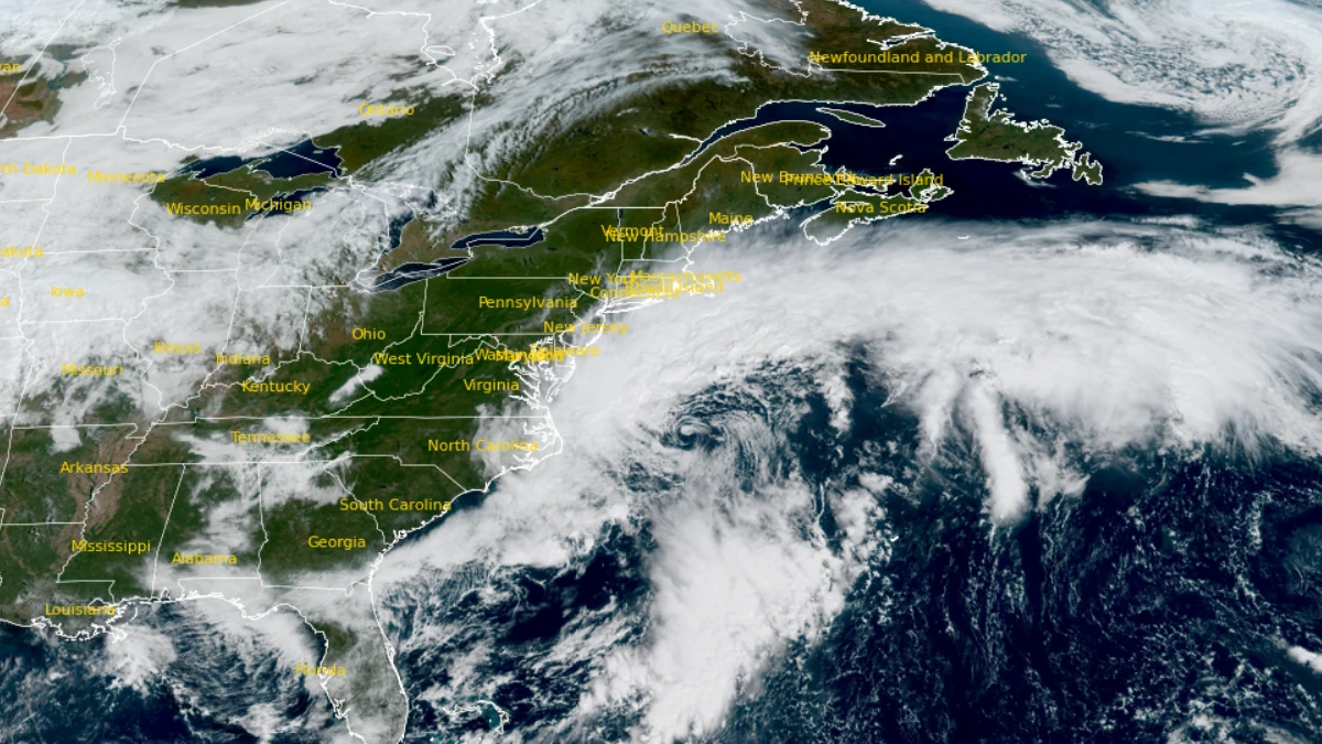
Satellite image of U.S. East Coast at 15:10 UTC on September 25, 2026. Credit: NOAA/GOES-19, RAMMB/CIRA, The Watchers
A deepening coastal low moving north along the United States East Coast was producing a prolonged period of onshore winds, rain, high surf and tidal flooding. NWS Boston/Norton expected the system to remain slow-moving through the weekend, extending coastal flooding and beach erosion across several high-tide cycles.
The office forecast 75–125 mm (3–5 inches) of rain across southern New England over 72 hours, with the highest totals over eastern Massachusetts and Rhode Island.
The hazard footprint was not uniform. Advisory-level flooding and dangerous surf extended into Florida and the Carolinas, while warning-level tidal flooding covered parts of the Outer Banks, Chesapeake region, New Jersey, New York and eastern Massachusetts.
High Wind Warnings covered exposed parts of the New Jersey and Delaware coasts and much of eastern Massachusetts and Rhode Island, where gusts up to 95 km/h (60 mph) were forecast.
NWS Boston/Norton, Massachusetts
High Wind Warnings covered exposed eastern and southeastern Massachusetts and most of Rhode Island through 02:00 EDT (06:00 UTC) on September 27. Northeast winds of 40–55 km/h (25–35 mph), with gusts up to 95 km/h (60 mph), were forecast across the principal warning area.
NWS warned of downed branches and power lines, power outages and difficult travel for high-profile vehicles.
A Coastal Flood Warning was in effect from 17:00 EDT (21:00 UTC) Friday through 20:00 EDT Sunday (00:00 UTC on September 28) for Eastern Essex, Suffolk, Eastern Norfolk, Eastern Plymouth, Barnstable, Dukes and Nantucket counties. NWS forecast 0.3–0.6 m (1–2 feet) of inundation, with minor coastal flooding and pockets of moderate flooding over several high-tide cycles.
The greatest flooding risk was south of Boston and across Cape Cod and the islands. A Coastal Flood Advisory covered the southern coasts of Massachusetts and Rhode Island over the same period.
A High Surf Advisory remained in effect through 20:00 EDT Sunday, with breaking waves of 1.8–4 m (6–13 feet). NWS Boston/Norton forecast 75–125 mm (3–5 inches) of rain across southern New England during the event, with the heaviest totals over eastern Massachusetts and Rhode Island.
NWS Charleston, South Carolina
Coastal Flood Advisories for Coastal Colleton and Charleston counties expired at 09:00 EDT (13:00 UTC) on September 25. The products had forecast up to 0.15 m (0.5 feet) of inundation above normally dry ground along shorelines and tidal waterways, with some vulnerable roads becoming impassable around the morning high tide.
NWS Wilmington, North Carolina
Coastal Flood Advisories for Coastal Pender, Coastal New Hanover and Coastal Brunswick counties in North Carolina and Coastal Horry and Coastal Georgetown counties in South Carolina expired at 09:00 EDT on September 25. Forecast inundation reached 0.3 m (1 foot) in Pender, New Hanover and Brunswick and 0.15 m (0.5 feet) in Horry and Georgetown.
A separate advisory for the lower Cape Fear River, including downtown Wilmington, expired at 11:00 EDT. It had forecast up to 0.15 m (0.5 feet) of flooding along parts of Battleship Road and USS North Carolina Road.
NWS Wilmington expected elevated water levels to remain a concern after the Friday morning high tide as the offshore storm maintained an onshore water setup.
NWS Newport/Morehead City, North Carolina
At 10:04 EDT (14:04 UTC) on September 25, NWS Newport/Morehead City extended Coastal Flood Warnings for Hatteras and Ocracoke islands through 11:00 EDT (15:00 UTC) on September 26. Inundation of 0.6–1.2 m (2–4 feet) above ground was forecast in low-lying shoreline and tidal-waterway areas, with up to 0.3 m (1 foot) of sound-side flooding possible under persistent northerly winds.
North Carolina Highway 12 remained closed from the Basnight Bridge to Rodanthe on Hatteras Island. Portions of Highway 12 on Ocracoke remained closed between the Pony Pens and the ferry dock.
The office extended the Northern Outer Banks Coastal Flood Advisory through 11:00 EDT Saturday, with 0.3–0.9 m (1–3 feet) of inundation possible. High Surf Advisories remained in effect through 20:00 EDT Saturday (00:00 UTC on September 27), with breaking waves of 3–4.6 m (10–15 feet) forecast on Hatteras Island and the Northern Outer Banks.
Beach Hazards Statements continued through Friday evening for dangerous rip currents, large breaking waves and strong longshore currents.
NWS Wakefield, Virginia
Coastal Flood Warnings remained in effect across southeastern and eastern Virginia, parts of Maryland’s Eastern Shore and Eastern Currituck County in North Carolina. The Maryland Beaches, Accomack and Northampton counties remained under warning through 02:00 EDT (06:00 UTC) on September 27, with 0.3–0.6 m (1–2 feet) of inundation forecast and a High Surf Advisory in effect through 06:00 EDT (10:00 UTC) Saturday.
Westmoreland, Richmond, Northumberland, Lancaster, Middlesex, Mathews and western and eastern Essex counties remained under warning through 16:00 EDT (20:00 UTC) Saturday. Inundation of 0.6–0.9 m (2–3 feet) was forecast.
Chesapeake, Hampton, Poquoson, Suffolk, Norfolk and Portsmouth remained under warning through noon Saturday, while Eastern Currituck County remained under warning through 02:00 EDT Sunday. NWS said forecast water levels could close numerous roads and flood low-lying property, vehicles and waterfront structures.
The City of Norfolk said crews were responding to roadway flooding, drainage problems and transportation disruptions. The city warned that Hampton Boulevard near Surrey Crescent and Larchmont would become impassable at high tide and identified several other roads vulnerable to tidal flooding.
NWS Baltimore/Washington
Coastal Flood Advisories remained in effect along parts of the tidal Potomac and Chesapeake shoreline after earlier warning-level products were downgraded in some locations. Anne Arundel County remained under an advisory through 21:00 EDT on September 25 (01:00 UTC on September 26), while St. Mary’s County remained under an advisory through 05:00 EDT (09:00 UTC) Saturday.
Calvert, Charles and King George counties remained under advisories through 07:00 EDT (11:00 UTC) Saturday. The Alexandria, Arlington and Falls Church shoreline remained under an advisory through 22:00 EDT Friday (02:00 UTC Saturday).
The products forecast flooding of low-lying shoreline areas and tidal roads, with the magnitude varying by jurisdiction.
NWS Mount Holly, New Jersey
Warning-level tidal flooding covered extensive parts of coastal New Jersey and Delaware. Middlesex and Western Monmouth counties remained under a Coastal Flood Warning through 15:00 EDT (19:00 UTC) on September 27, with 0.3–0.6 m (1–2 feet) of inundation forecast.
Eastern Monmouth and Coastal Ocean carried the same Sunday afternoon expiration, while their High Surf Advisories extended through 20:00 EDT Sunday (00:00 UTC on September 28). Breaking waves could reach 4 m (13 feet) in Eastern Monmouth and 3.7 m (12 feet) in Coastal Ocean.
Kent and Inland Sussex counties in Delaware, the Delaware Beaches, Atlantic and Cape May counties and the Atlantic Coastal Cape May and Coastal Atlantic zones remained under Coastal Flood Warnings through 02:00 EDT (06:00 UTC) Sunday. Forecast inundation was generally 0.3–0.6 m (1–2 feet).
NWS forecast widespread roadway flooding and impassable roads, with damage to vulnerable structures possible. The office said major tidal-flood impacts could not be ruled out around Rehoboth Bay, Indian River and some back-bay communities.
The Delaware Beaches and exposed New Jersey coast were also under a High Wind Warning from 18:00 EDT (22:00 UTC) Friday through 06:00 EDT (10:00 UTC) Sunday. North winds of 50–65 km/h (30–40 mph), with gusts up to 95 km/h (60 mph), were forecast for the Delaware Beaches, Eastern Monmouth, Atlantic Coastal Cape May, Coastal Atlantic and Coastal Ocean.
A Wind Advisory preceded the warning through 18:00 EDT Friday, with northeast winds of 40–55 km/h (25–35 mph) and gusts up to 70 km/h (45 mph). NWS warned that damaging winds could bring down trees and power lines and make travel difficult for high-profile vehicles.
NWS New York/Upton, New York
Coastal Flood Warnings were in effect from 18:00 EDT (22:00 UTC) on September 25 through 18:00 EDT (22:00 UTC) on September 27 across parts of the New York metropolitan shoreline, Long Island and southern Connecticut. Several zones were forecast to receive 0.3–0.6 m (1–2 feet) of inundation.
Southern New Haven, Southern Fairfield, Southern Westchester, the Bronx and Northern Queens were among the areas with forecasts of 0.6–0.9 m (2–3 feet). NWS expected flooding over multiple high-tide cycles, with the worst conditions in several zones forecast around the daytime high tides on Saturday and Sunday.
High Surf Advisories continued through 20:00 EDT Saturday along exposed ocean beaches. The highest forecast wave heights reached 4.6 m (15 feet) in parts of Suffolk County.
Wind Advisories covered New York City, Long Island, southern Westchester and much of southern Connecticut through 06:00 EDT (10:00 UTC) Sunday, with the strongest gusts focused on eastern and coastal areas.
NWS Gray, Maine
At 10:26 EDT (14:26 UTC) on September 25, NWS Gray upgraded the Coastal Flood Watch for Coastal York County in Maine and Coastal Rockingham County in New Hampshire to a Coastal Flood Advisory. The advisory was in effect from 10:00 EDT (14:00 UTC) on September 26 through 23:00 EDT on September 27 (03:00 UTC on September 28), with up to 0.3 m (1 foot) of inundation forecast.
A High Surf Advisory remained in effect through 20:00 EDT Sunday, with breaking waves of 2.1–3.7 m (7–12 feet) and a high risk of rip currents. NWS expected elevated water and large waves to produce splashover and beach erosion across multiple tide cycles from Saturday morning through Sunday evening.
Satellite image of U.S. East Coast at 15:10 UTC on September 25, 2026. Credit: NOAA/GOES-19, RAMMB/CIRA, The Watchers
NWS Melbourne, Florida
A Coastal Flood Advisory for Coastal Volusia County expired at 11:00 EDT (15:00 UTC) on September 25 after minor flooding was forecast in vulnerable low-lying lots, parks and roads near the shoreline.
A High Surf Advisory remained in effect through 04:00 EDT (08:00 UTC) on September 26 for breaking waves of 1.2–2.7 m (4–9 feet), while a High Rip Current Risk continued through late Saturday night. NWS listed localized beach erosion and dangerous swimming and surfing conditions among the expected hazards.
NWS Jacksonville, Florida
A Coastal Flood Advisory remained in effect along the St. Johns River Basin through 08:00 EDT (12:00 UTC) on September 26. The advisory covered Eastern Clay, Eastern Putnam, Trout River, South Central Duval and Western St. Johns, where minor flooding of lots, parks and roads and isolated road closures were possible.
Coastal Duval County remained under a Coastal Flood Advisory through 08:00 EDT Saturday, a High Surf Advisory through 02:00 EDT (06:00 UTC) Saturday and a High Rip Current Risk through late Saturday night. Breaking waves of 1.8–2.7 m (6–9 feet) were forecast.
Coastal Flood Advisories for Coastal Nassau, Coastal Flagler, Coastal St. Johns, Coastal Glynn and Coastal Camden expired at 11:00 EDT on September 25. High-surf and rip-current hazards continued after the coastal-flood products expired.
References:
1 Coastal Flood Warning – NOAA/NWS – September 25, 2026
2 Coastal Flood Advisory – NOAA/NWS – September 25, 2026
3 High Wind Warning – NOAA/NWS – September 25, 2026

Rishav Kothari is Editor-in-Chief of The Watchers, where he runs the newsroom and covers earthquakes, volcanoes, severe weather and space weather.
Published in the last 24 hours
- In September 1859, a solar storm lit up the night sky so brightly that gold miners in the Rocky Mountains woke up after midnight and started cooking breakfast, convinced the aurora glowing over their camp was the sunrise Epicenter
- A patch of warm Pacific water that could become the strongest El Niño in more than 70 years sits thousands of miles from any American town, yet it is already the main reason NOAA expects a wetter winter across the South and a milder one across the North
- A 19-year-old Nebraska teacher reportedly tied her pupils together with twine and led them to safety through a blizzard in January 1888 Epicenter
- NASA built the Opportunity rover to last 90 days on Mars, and Martian winds helped keep it alive for nearly 15 years by blowing dust off its solar panels, until a planet-wide dust storm in 2018 blocked sunlight and silenced the rover Epicenter
