
Hurricane Polo brings heavy rain to Mexico, NHC forecasts Baja California approach
Hurricane Polo’s outer rainbands brought heavy rain to southwestern Mexico on September 24, 2026, with a Tropical Storm Warning in effect from Tecpan de Galeana to Manzanillo. Mexico had extended the warning westward overnight as the Category 5 hurricane remained offshore, bringing a risk of flooding, mudslides and dangerous coastal conditions. Polo is forecast to approach the Baja California Peninsula as a hurricane early in the week beginning September 28.
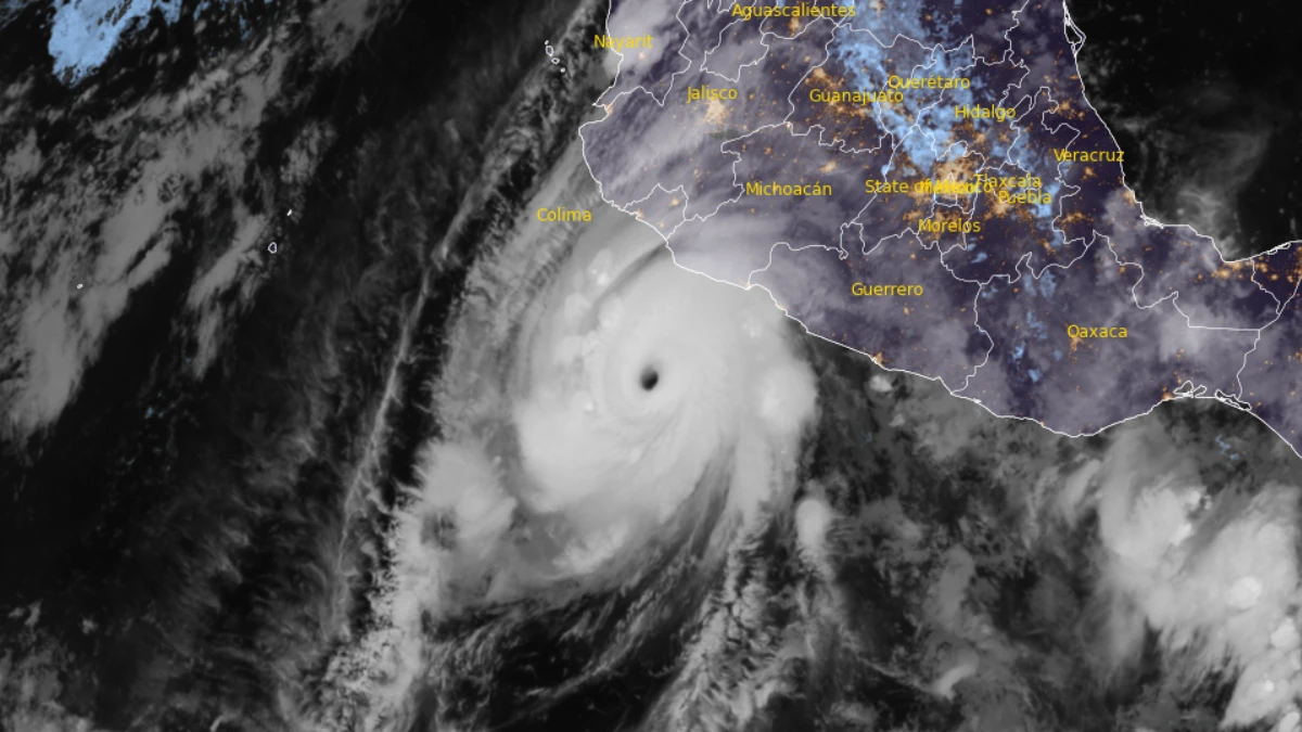
Satellite image of Hurricane Polo at 09:00 UTC on September 24, 2026. Credit: NOAA/GOES-19, RAMMB/CIRA, The Watchers
Hurricane Polo’s outer rainbands brought heavy rain to coastal southwestern Mexico on September 24, 2026, while the Category 5 hurricane remained offshore, according to the National Hurricane Center (NHC).
The agency warned of life-threatening flooding and mudslides and forecast that Polo would approach the Baja California Peninsula as a hurricane early in the week beginning September 28.
At 03:00 CST (09:00 UTC) on September 24, Polo was centered approximately 240 km (150 miles) west-southwest of Zihuatanejo and 290 km (180 miles) south-southeast of Manzanillo, according to the NHC.
Maximum sustained winds were 260 km/h (160 mph), with an estimated minimum central pressure of 923 hPa. Polo was moving northwest at 15 km/h (9 mph).
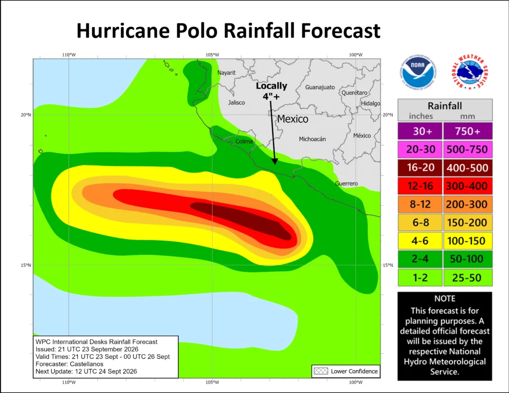
The NHC forecast about 100–150 mm (4–6 inches) of rain across coastal Guerrero through September 24, with isolated totals up to about 200 mm (8 inches). Rainfall of about 50–100 mm (2–4 inches) was possible along coastal Michoacán, Colima and Jalisco.
The agency warned that the rainfall could cause life-threatening flooding and mudslides, especially in steep terrain.
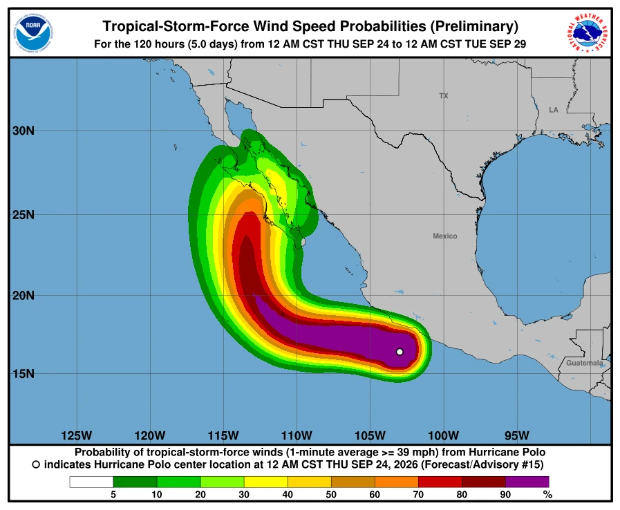
A Tropical Storm Warning covered the coast from Tecpan de Galeana to Manzanillo, with tropical storm conditions expected during the hours following the advisory. A Tropical Storm Watch extended from west of Manzanillo to Playa Pérula, where those conditions were possible later on September 24.
Mexico had extended the warning westward from Punta San Telmo to Manzanillo at 21:00 CST on September 23 (03:00 UTC on September 24). Advisory 15 left the warning and watch boundaries unchanged.

The NHC forecast swells from Polo along southwestern Mexico during the following two days, spreading north along west-central Mexico and toward Baja California Sur from September 25 into the weekend. The swells were likely to cause life-threatening surf, rip currents, and coastal flooding.
Polo’s core was expected to remain offshore of southwestern Mexico on September 24 before moving farther out to sea. The NHC forecast a turn toward the west-northwest on September 24–25, followed by northwestward movement on September 26.
A building ridge over northern Mexico and the south-central United States was expected to steer Polo farther offshore. The hurricane was then forecast to turn northward toward the Baja California Peninsula as it reached the ridge’s western edge late in the weekend.
Increasing vertical wind shear was expected to cause gradual weakening during the weekend and early the following week, although Polo was forecast to remain a hurricane during its approach to the peninsula.
The NHC advised people in the peninsula to monitor forecast updates and ensure their preparedness plans were in place.
Polo first reached Category 5 at 06:00 CST (12:00 UTC) on September 22, with maximum sustained winds of 260 km/h (160 mph). The NHC raised the estimate to 270 km/h (165 mph) at 15:00 UTC and to 285 km/h (180 mph) in an update valid at 19:00 UTC.
After weakening to Category 4 on September 23, Polo returned to Category 5 in an NHC update issued at 18:40 CST that day (00:40 UTC on September 24). Maximum sustained winds were again estimated at 260 km/h (160 mph).
In Discussion 14, valid at 03:00 UTC on September 24, the NHC described a clearer, warmer eye surrounded by deep convection and said Polo had completed an eyewall replacement cycle.
References:
1 Hurricane Polo Public Advisory 15 – NOAA/NHC – September 24, 2026
2 Hurricane Polo Forecast Discussion 15 – NOAA/NHC – September 24, 2026, 09:00 UTC.
3 Hurricane Polo Public Advisory 14 – NOAA/NHC – September 24, 2026

Rishav Kothari is Editor-in-Chief of The Watchers, where he runs the newsroom and covers earthquakes, volcanoes, severe weather and space weather.

Hurricanes Nolo Polo punishment from God to avoid death by these punishments from God hurricanes tornadoes floods lightnings hailstorm heatwave strong earthquakes more mag 7 earthquake tsunami volcano meteor North and South Americans to convert to islam immediately September 27,2026.