
Rapidly intensifying Tropical Storm Polo forecast to become major hurricane near southwestern Mexico
Tropical Storm Polo was rapidly intensifying off southwestern Mexico on September 21, 2026, with maximum sustained winds reaching 100 km/h (65 mph) at 09:00 CST (15:00 UTC), according to the National Hurricane Center (NHC). NHC forecasts Polo to become a hurricane later Monday and a major hurricane on Tuesday while moving near the southwestern Mexican coast, where a Tropical Storm Watch is already in effect.
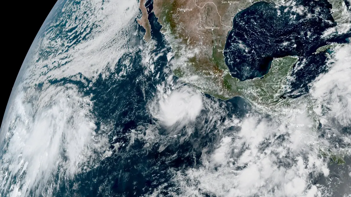
Satellite image of Tropical Storm Polo at 17:10 UTC on September 21, 2026. Credit: NOAA/GOES-East, RAMMB/CIRA, The Watchers
- Heavy rainfall associated with Polo will impact coastal portions of southwest Mexico through Thursday. This rainfall may produce life-threatening flooding and mudslides, especially in areas of steep terrain.
- Polo is forecast to strengthen to a major hurricane while it moves closer to the coast of southwestern Mexico during the next few days.
- Although the core of the hurricane is forecast to stay offshore, it is too soon to determine the exact location or magnitude of impacts.
- A Tropical Storm Watch is in effect for portions of southwestern Mexico.
At 09:00 CST (15:00 UTC) on September 21, the center of Tropical Storm Polo was located about 410 km (255 miles) south-southeast of Manzanillo and 320 km (200 miles) southwest of Zihuatanejo. NHC estimated maximum sustained winds at 100 km/h (65 mph), with a minimum central pressure of 997 hPa, as the storm moved slowly eastward at 7 km/h (5 mph).
Polo has strengthened substantially during the past six hours. NHC reported maximum sustained winds of 75 km/h (45 mph) and a pressure of 1 003 hPa at 03:00 CST (09:00 UTC), followed by winds of 85 km/h (50 mph) and a pressure of 1 001 hPa at 06:00 CST (12:00 UTC). By 09:00 CST, winds had reached 100 km/h (65 mph).
Satellite imagery showed a developing central dense overcast with very deep convection concentrated around Polo’s core. Microwave imagery detected a small eye beneath the cloud cover and signs of a banded eyewall, while the Tropical Analysis and Forecast Branch supported an initial intensity of 100 km/h (65 mph). A NOAA Hurricane Hunter aircraft was en route to investigate the storm and obtain direct measurements.
NHC said Polo’s compact inner core was moving over sea-surface temperatures above 30.5°C (86.9°F), with light vertical wind shear and abundant mid-level moisture. Forecast guidance consistently supported rapid intensification, prompting NHC to raise the official intensity forecast substantially from the previous advisory.
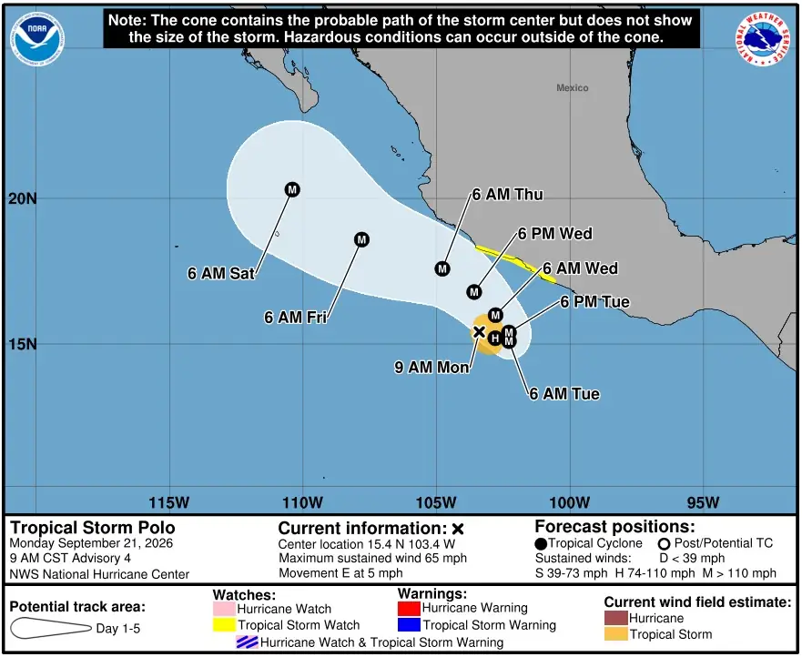
The 15:00 UTC forecast brings Polo to sustained winds of 155 km/h (100 mph) by 18:00 CST (00:00 UTC September 22), followed by 195 km/h (120 mph) by 06:00 CST (12:00 UTC) Tuesday. Winds are forecast to reach 230 km/h (145 mph) by Tuesday evening and 250 km/h (155 mph) by Wednesday morning.
NHC forecasts Polo to reach sustained winds near 260 km/h (160 mph) by 18:00 CST Wednesday (00:00 UTC September 24) and maintain that intensity through Thursday morning. Gradual weakening is forecast afterward, with Polo still expected to remain a major hurricane through the end of the five-day forecast period.
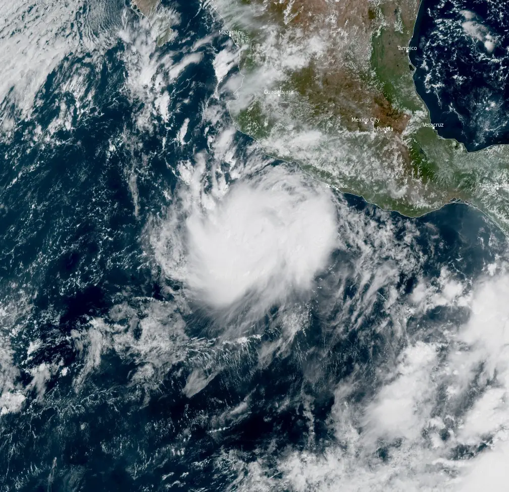
Polo remained within weak steering currents Monday morning and was drifting eastward. NHC expects a slow eastward or southeastward motion through Monday night before a mid-level ridge develops over Mexico and turns the cyclone sharply toward the west-northwest or northwest beginning late Tuesday.
The forecast places Polo near or south of the southwestern Mexican coast during the next several days before carrying it farther northwest and south of the Baja California Peninsula later in the week. NHC reported a large north-south spread among track models and classified the track forecast as low confidence. Guidance had shifted somewhat south before the 09:00 CST advisory, and the official NHC track was adjusted in the same direction.
A Tropical Storm Watch is in effect along the Mexican coast from Tecpan de Galeana to Punta San Telmo. Tropical-storm conditions are possible within the watch area by Tuesday night or early Wednesday, and NHC said the watch would probably be extended westward later Monday or Monday night.
Tropical-storm-force winds extended as far as 110 km (70 miles) from Polo’s center at 15:00 UTC. The forecast wind field expands substantially as the cyclone strengthens, although NHC currently keeps the forecast center offshore.
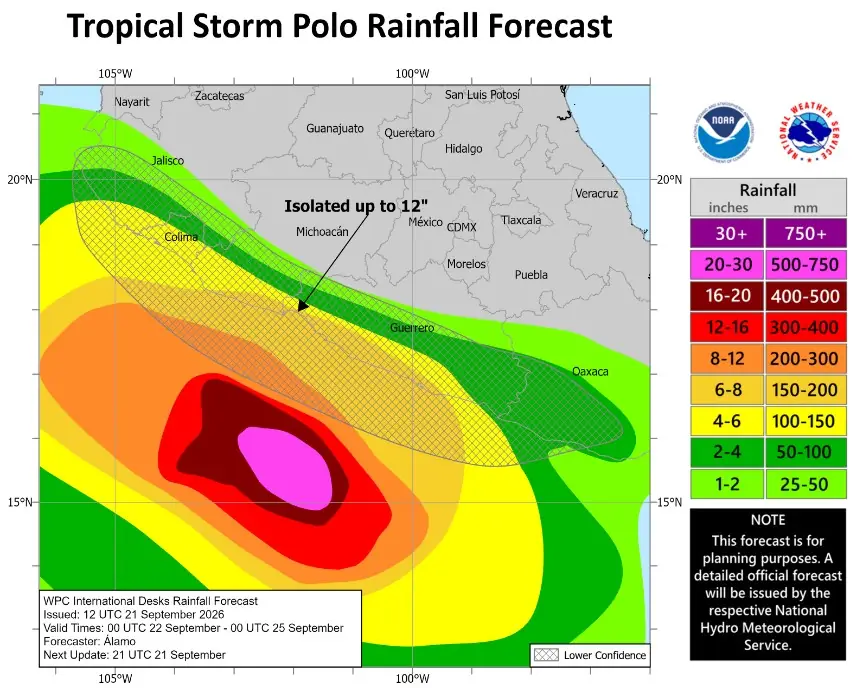
NHC forecasts 100–200 mm (4–8 inches) across coastal portions of Guerrero and Michoacán through Thursday, with isolated totals of up to 300 mm (12 inches). The rainfall can produce life-threatening flooding and mudslides, particularly in steep terrain.
Coastal portions of Oaxaca, Colima and Jalisco are forecast to receive 75–150 mm (3–6 inches) through Thursday. The rainfall threat extends well beyond Polo’s compact inner wind core and will depend on the storm’s eventual track relative to the mountainous southwestern Mexican coast.
Swells generated by Polo are expected to begin reaching parts of southwestern Mexico on Tuesday. NHC warned that the increasing swell will produce dangerous surf and rip-current conditions along portions of the coast.
Although NHC forecasts Polo to become a major hurricane while moving closer to southwestern Mexico, the agency said it remains too early to determine the exact location or magnitude of coastal impacts. The official forecast currently keeps the hurricane’s core offshore, but the large spread among track models leaves the eventual distance from the coast unresolved.
References:
1 Tropical Storm Polo Advisory Number 4 – NWS/NHC – September 21, 2026
2 Tropical Storm Polo Forecast Advisory Number 4 – NWS/NHC – September 21, 2026
3 Tropical Storm Polo Discussion Number 4 – NWS/NHC – September 21, 2026

Teo Blašković founded The Watchers in 2011 and edited it until 2026, covering seismic and volcanic activity, extreme weather, space weather and near-Earth objects. Articles on this page are his archive.
Published in the last 24 hours
- Bay of Bengal system to become Cyclone Akvan, landfall forecast between Nellore and Tuni on November 20, India
- Tropical Cyclone Xavier reaches Category 2 over Northern Cook Islands, gale warning for Manihiki and Rakahanga
- El Niño floods kill 2 in Guayaquil as 172.8 mm of rain swamps Milagro, Ecuador's toll rises to 14
- Southern Thailand braces for heavy rain, 15 provinces on flood and landslide alert for November 18-22

Hurricane Polo punishment from God To avoid death by hurricanes floods lightnings hailstorm tornadoes heatwave wildfires strong earthquakes more mag 7 earthquake tsunami volcano meteorites Mexicans North and South Americans to convert to islam September 23,2026.