
Moderate Risk of excessive rainfall issued for northeastern Kansas and northwestern Missouri
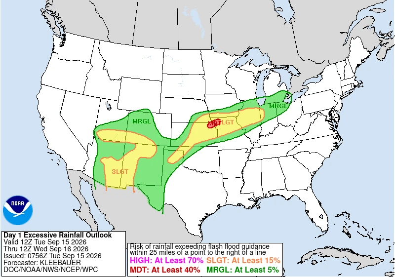
The Weather Prediction Center (WPC) placed parts of northeastern Kansas and northwestern Missouri under a Moderate Risk of excessive rainfall from 07:00 CDT (12:00 UTC) on September 15 through 07:00 CDT (12:00 UTC) on September 16, 2026, as repeated thunderstorms threaten flash flooding. The Moderate Risk extends into far southeastern Nebraska, while parts of the northern Kansas City/Pleasant Hill forecast area have already received more than 127 mm (5 inches) of rain and could receive another 25–76 mm (1–3 inches).

WPC day 1 ERO, September 15-16, 2026. Credit: NWS/WPC
WPC issued the Moderate Risk for excessive rainfall on September 15. The greatest threat extends from areas north of Topeka toward St. Joseph, Missouri, where recent heavy rain has lowered the amount of additional rainfall required to cause flooding.
A surrounding high-end Slight Risk includes the Kansas City metropolitan area, much of northern Missouri and additional portions of northeastern Kansas and southeastern Nebraska.
A slow-moving cold front is forecast to reach central Kansas and Missouri during the afternoon and evening. Southwesterly flow roughly parallel to the boundary could cause thunderstorms to move repeatedly across the same locations, particularly during the evening and overnight as a strengthening low-level jet supplies additional moisture.
Precipitable-water values near 51 mm (2 inches) are forecast. High-resolution guidance supports average rainfall totals of approximately 51–76 mm (2–3 inches) across the main corridor, while blended guidance produces approximately 76–127 mm (3–5 inches) across parts of northeastern Kansas and northwestern Missouri.
Probabilities of rainfall rates exceeding 25 mm/h (1 inch/h) reach approximately 40–70% for several hours in parts of the Moderate Risk area. Local flash-flood guidance is as low as approximately 25 mm (1 inch) in one hour and 51 mm (2 inches) in three hours.
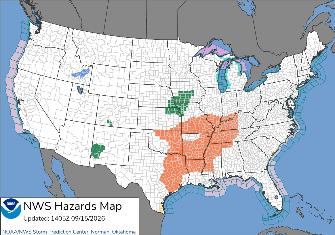
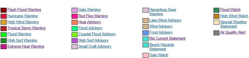
The NWS Kansas City/Pleasant Hill office expanded an existing Flood Watch at 02:57 CDT (07:57 UTC) on September 15 to include the Kansas City metropolitan area. The newly included counties are Johnson, Leavenworth and Wyandotte in Kansas and Clay, Jackson and Platte in Missouri.
The expanded area joins an existing watch covering Atchison and Doniphan counties in Kansas and 15 counties across northwestern Missouri. The watches begin at 13:00 CDT (18:00 UTC) on September 15 and continue through Wednesday afternoon. Training thunderstorms and localized heavy downpours could cause flash flooding, river flooding and excessive runoff into creeks, streams and low-lying areas.
The NWS Topeka office continued a Flood Watch for Clay and Washington counties in north-central Kansas and Brown, Jackson, Jefferson, Marshall, Nemaha, Pottawatomie and Riley counties in northeastern Kansas. That watch also runs from 13:00 CDT on September 15 through Wednesday afternoon. NWS said some locations could receive approximately 76 mm (3 inches), with locally higher totals possible.
A Flood Watch issued by the NWS Omaha/Valley office remains in effect through Tuesday evening across southeastern Nebraska and southwestern Iowa. Recent heavy rainfall and repeated thunderstorms have increased the risk of flash flooding in parts of the Omaha, Lincoln and Council Bluffs areas.
Farther north, the NWS Des Moines office continued a Flood Watch for central and southern Iowa at 08:59 CDT (13:59 UTC) on September 15. Light to moderate rain was expected during the morning before becoming less widespread in the afternoon. Heavy rain is forecast to return late Tuesday night into Wednesday, particularly across far southern Iowa. The watch remains in effect through Wednesday afternoon.
NWS Des Moines also issued separate river Flood Watches for the East Nishnabotna River near Atlantic and the Raccoon River at Fleur Drive in Des Moines. Forecasts indicated that both waterways could reach flood stage following observed and forecast rainfall.
For the next outlook period, from 07:00 CDT (12:00 UTC) on September 16 through 07:00 CDT (12:00 UTC) on September 17, WPC maintains a Slight Risk from the Missouri River in southeastern Nebraska and northeastern Kansas across much of Iowa, northern Missouri and northern Illinois into central Indiana.
Heavy rain could persist across northern Missouri early Wednesday before additional thunderstorms develop near the stalled or slowly retreating front. Another round is possible across Iowa and northern Illinois Wednesday night. WPC said the latest guidance was less aggressive than earlier forecasts but continued to support localized totals of approximately 25–76 mm (1–3 inches), with wet soils increasing the potential for flash flooding.
Separate excessive-rainfall threat develops across the Southwest
A separate excessive-rainfall threat covers the Southwest and Southern Rockies. WPC maintains a Slight Risk on September 15 across parts of eastern Arizona and western New Mexico, where repeated convection and anomalously high atmospheric moisture could produce localized rainfall totals of approximately 51–76 mm (2–3 inches).
The threat is forecast to expand on September 16 across the eastern two-thirds of Arizona, most of New Mexico and southern Colorado. Precipitable-water anomalies may reach two to three standard deviations above normal and could approach four standard deviations in parts of New Mexico. High-resolution guidance shows a strong signal for totals exceeding 51 mm (2 inches) across parts of Arizona and New Mexico.
The NWS Albuquerque office issued a Flood Watch for the Southwest Mountains, San Francisco River Valley and San Agustin Plains and adjacent lowlands from 11:00 MDT (17:00 UTC) on September 15 through the evening. These areas received approximately 13–51 mm (0.5–2 inches) of rain on September 14 and early September 15.
Stronger storms could produce rainfall rates of approximately 25–51 mm/h (1–2 inches/h), creating a flash-flood threat on and downstream of the Sacaton/Hummingbird burn scar.
The NWS El Paso/Santa Teresa office continued a Flood Watch for the southern Gila region from 11:00 MDT on September 15 through 06:00 MDT (12:00 UTC) on September 16. The watch includes most of northern Grant County and far western Sierra County near the Black Range. Multiple disturbances could produce rounds of thunderstorms and torrential downpours, particularly during the evening and overnight.
In Colorado, the NWS Pueblo office continued a Flood Watch for the eastern San Juan Mountains and Upper Rio Grande Valley from Wednesday afternoon through Thursday evening. Multiple rounds of thunderstorms could affect areas including Creede, South Fork and Wolf Creek Pass.
The broader pattern is associated with a slow-moving front intercepting a moist and unstable air mass drawn northward toward a deep cyclone over Ontario. Across the Southwest, monsoonal moisture is increasing ahead of an approaching upper-level trough, supporting repeated thunderstorms through midweek.
References:
1 Excessive Rainfall Discussion – NWS/WPC – September 15, 2026
2 Short Range Forecast Discussion – NWS/WPC – September 15, 2026

Rishav Kothari is Editor-in-Chief of The Watchers, where he runs the newsroom and covers earthquakes, volcanoes, severe weather and space weather.
Published in the last 24 hours
- 2 atmospheric rivers to bring heavy Sierra snow and California flood risk
- 190 mm of rain and 131 km/h gusts hit New Zealand's South Island, flooding West Coast highways
- Huge waves pummel California coast during strong El Niño, flooding streets and closing piers from Pacifica to San Diego
- Bay of Bengal system to become Cyclone Akvan, landfall forecast between Nellore and Tuni on November 20, India
