
Discharge rises, significant gas pollution reported during Múlakvísl glacial outburst flood, Iceland
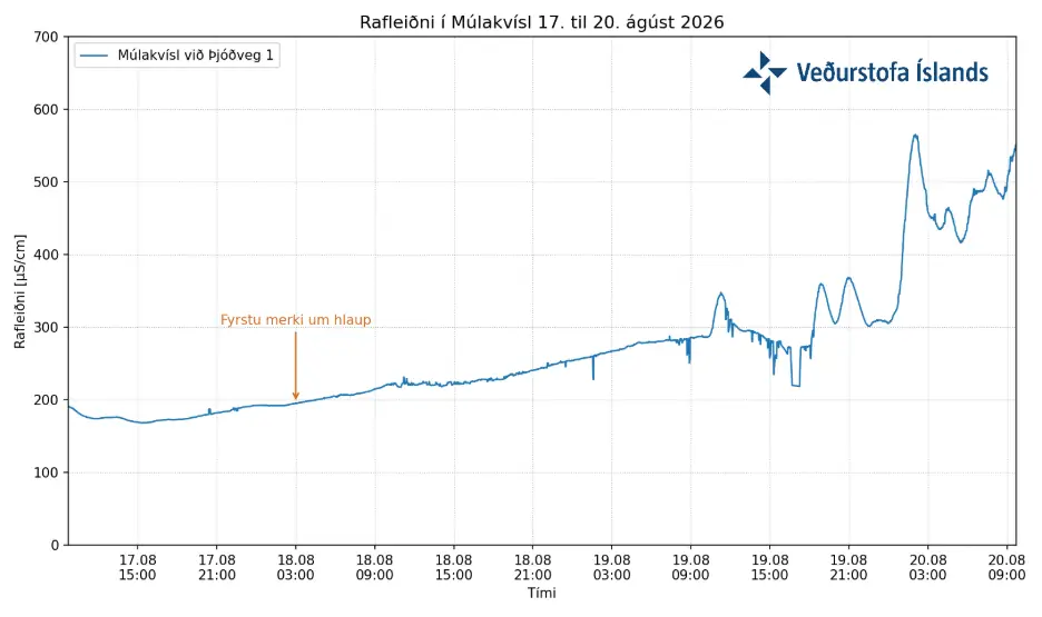
Electrical conductivity in Múlakvísl rose to just over 500 µS/cm during an ongoing glacial outburst flood on August 20, 2026, while discharge increased and significant gas pollution continued, according to the Icelandic Meteorological Office (IMO). The river level had not risen significantly, but webcam observations showed the river spreading across a wider area.

Satellite image of Kötlujökull, Iceland, on August 20, 2026. Credit: CopernicusEU/Sentinel-2, The Watchers
The glacial outburst flood in Múlakvísl began on August 18. By August 19, electrical conductivity in the river rose to approximately 285 µS/cm, while overnight measurements from IMO’s gas monitor at Láguhvolar showed hydrogen sulfide (H2S) concentrations above the health-protection limit.
Conditions changed further during the evening of August 19, when conductivity rose fairly sharply. By August 20, it reached just over 500 µS/cm, a level IMO described as unusually high compared with recent glacial outburst floods in Múlakvísl. A similar value was last recorded during the July 2017 flood, when conductivity peaked at 580 µS/cm.
River discharge also increased by August 20, with webcam observations showing Múlakvísl spreading across a wider area despite no significant rise in water level.
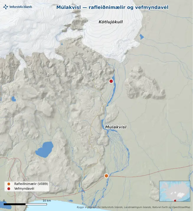
The Láguhvolar monitor, approximately 2 km (1.2 miles) from the margin of Kötlujökull, recorded H2S concentrations above the health-protection limit overnight before the August 19 update, while IMO continued to report significant gas pollution on August 20.
The agency advised people not to remain near Múlakvísl or close to where the river emerges at the glacier margin, adding that calm weather in recent days increased the risk of gas accumulating in depressions. Anyone experiencing irritation of the nose or eyes was advised to leave the area immediately.
Several geothermal areas are known beneath Mýrdalsjökull, where meltwater drains continuously. Depending on local topography, water can accumulate beneath the ice before draining, while both the volume stored and the rate of release can vary.
Glacial outburst floods of the current magnitude are well known in Múlakvísl. This area is part of IMO’s flood-monitoring network south of Mýrdalsjökull, where instruments continuously measure water level, electrical conductivity and water temperature. The monitoring system is designed to detect floods originating from subglacial geothermal systems and other meltwater sources.
Mýrdalsjökull covers Katla, one of Iceland’s active volcanic systems. Geothermal activity beneath the ice regularly produces meltwater that drains into rivers including Múlakvísl.
Although large Katla eruptions can generate major glacial outburst floods, the current IMO update describes the August 2026 event as a glacial outburst flood associated with geothermal meltwater.
References:
1 Increased discharge and significant gas pollution in Múlakvísl – IMO – August 20, 2026

Teo Blašković founded The Watchers in 2011 and edited it until 2026, covering seismic and volcanic activity, extreme weather, space weather and near-Earth objects. Articles on this page are his archive.
Published in the last 24 hours
- El Niño floods kill 2 in Guayaquil as 172.8 mm of rain swamps Milagro, Ecuador's toll rises to 14
- Southern Thailand braces for heavy rain, 15 provinces on flood and landslide alert for November 18-22
- Paraná River floods force 4 547 from homes as water tops evacuation levels in 10 Argentine towns
- 190 mm of rain and 131 km/h gusts hit New Zealand's South Island, flooding West Coast highways
