
Tornado Watch issued for Nebraska, Iowa, and Missouri, higher-end threat expected across Kansas and Oklahoma
The NWS Storm Prediction Center issued Tornado Watch 134 at 17:00 UTC (12:00 CDT) on April 23, 2026, for eastern Nebraska, western and central Iowa, and northwest Missouri as severe thunderstorms began developing and increasing in coverage along a cold front. The watch includes tornado potential, damaging wind gusts up to 110 km/h (70 mph), and large hail up to 6.4 cm (2.5 inches), while a separate Enhanced Risk area across eastern Kansas and northern Oklahoma is expected to produce more intense severe storms later in the afternoon and evening.

Convective Outlook valid 14:00 EDT on April 23 to 14:00 EDT on April 24, 2026. Credit: NWS
The National Weather Service Storm Prediction Center (SPC) issued Tornado Watch 134 at 17:00 UTC (12:00 CDT) on April 23, covering eastern Nebraska, western and central Iowa, and northwest Missouri. The watch remains in effect until 00:00 UTC April 24 (19:00 CDT) and defines an active severe weather corridor where thunderstorms are developing and intensifying.
Severe storms are forming along a cold front extending across the central United States, with convective development underway from eastern Nebraska into western Iowa. Storm coverage is increasing from scattered to more widespread as forcing along the boundary strengthens and surface heating reduces remaining inhibition.
SPC identified a multi-hazard environment within the watch area. Tornado potential exists with semi-discrete storms, while scattered damaging wind gusts up to 110 km/h (70 mph) are expected as storms organize.
Large hail remains a primary hazard, with stones reaching 6.4 cm (2.5 inches) in diameter and isolated very large hail events up to this size.
Storm evolution is expected to follow a transition from semi-discrete supercells to clustered or linear modes through the afternoon. This transition will support an increasing risk of damaging winds and maintain embedded tornado potential as convective organization increases.
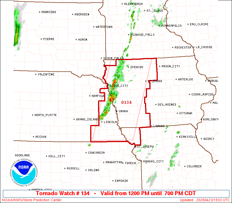
The watch area extends approximately 100 km (60 miles) east and west of a line from near Spencer, Iowa, to west of Falls City, Nebraska. Within this corridor, storm motion and boundary interaction allow storms to move off the front while maintaining structure during early development stages.
Aviation impacts include severe turbulence, hail up to 6.4 cm (2.5 inches), and wind gusts approaching 110 km/h (60 knots). Convective cloud tops are expected to reach approximately 15 km (50 000 feet).
This tornado watch follows Mesoscale Discussion 0501, which outlined increasing convective potential and assigned an 80 percent probability of watch issuance.
The current watch confirms that environmental conditions now support organized severe thunderstorms capable of producing tornadoes and significant hail.
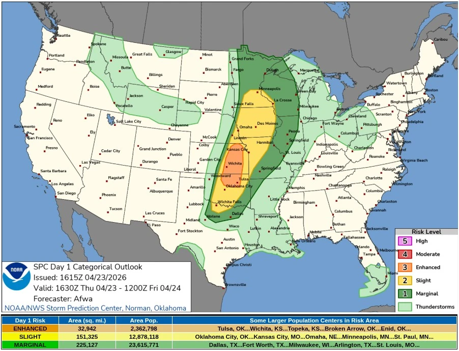
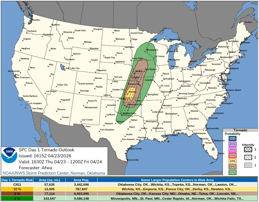
Further south, a separate corridor across eastern Kansas and northern Oklahoma remains under an Enhanced Risk in the Day 1 Convective Outlook, where a more unstable environment will support severe storm development later in the afternoon and evening.
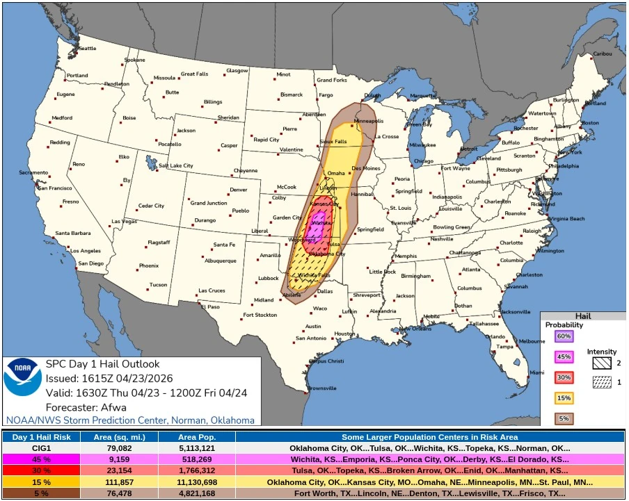
Storm initiation in this southern corridor is expected near a cold front and dryline intersection close to the Kansas–Oklahoma border. Deep-layer shear supports supercell structures, and initial storms in this environment may produce very large hail with diameters reaching 5-7.5 cm (2-3 inches).
As low-level shear increases through the evening, the tornado threat will expand, including the potential for strong tornadoes with storms that remain discrete.
Storm evolution in the southern sector will follow a similar progression, with discrete supercells during the initial phase transitioning into a more linear convective mode overnight. This transition will shift the dominant hazard toward damaging wind gusts as storms consolidate and move southeast into northeast Oklahoma and southwest Missouri.
The northern Tornado Watch area and the southern Enhanced Risk corridor are dynamically linked within the same synoptic-scale system, with the northern sector already in an active convective phase while the southern sector approaches peak instability later in the day.
References:
1 Tornado Watch 134 – NWS/SPC – April 23, 2026
2 Mesoscale Discussion 0501 – NWS/SPC – April 23, 2026
3 Day 1 Convective Outlook – NWS/SPC – April 23, 2026
I'm a dedicated researcher, journalist, and editor at The Watchers. With over 20 years of experience in the media industry, I specialize in hard science news, focusing on extreme weather, seismic and volcanic activity, space weather, and astronomy, including near-Earth objects and planetary defense strategies. You can reach me at teo /at/ watchers.news.
Commenting rules and guidelines
We value the thoughts and opinions of our readers and welcome healthy discussions on our website. In order to maintain a respectful and positive community, we ask that all commenters follow these rules.