
NWS data show heavy snow and significant ice from the January 2026 U.S. winter storm
Official data from the National Weather Service Weather Prediction Center (WPC) confirms widespread snow, sleet, and freezing rain accumulations across large portions of the United States during the January 23–26, 2026, winter storm. Preliminary data show snowfall exceeded 50 cm (20 inches) in parts of New England and the interior Northeast, while ice accretions reached 25 mm (1 inch) across portions of the Carolinas and northern Georgia. The system’s departure early on January 26 ended four days of significant winter weather affecting more than a dozen states.
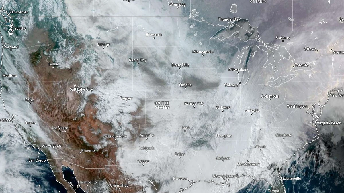
Satellite image of large winter storm over United States at 21:20 UTC on January 25, 2026. Credit: NOAA/GOES-East, Zoom Earth, The Watchers
A major winter storm that developed over the central United States on January 23 and moved eastward toward the Atlantic Coast by January 26 produced heavy snow, extensive ice accumulation, and widespread travel disruption. According to the Weather Prediction Center, the system’s coastal low reached a minimum central pressure of 996 hPa south of Cape Cod at 03:00 EST (08:00 UTC) on January 26 before moving offshore.
The highest measured snowfall totals were observed across southern New England and parts of New York State. In Massachusetts, Middleton recorded 52 cm (20.5 inches), while Holden and Newburyport each reported 51 cm (20 inches). Grafton and Ludlow both measured 48 cm (19 inches). Worcester Regional Airport reported 44 cm (17.5 inches), and Boston measured 42 cm (16.7 inches).
In Connecticut, Coventry registered 46 cm (18.2 inches), while Eastford, Glastonbury, and Simsbury each recorded 46 cm (18 inches). Several locations in Rhode Island and southeastern New York State reported comparable totals — Providence received 42 cm (16.7 inches), and New City, New York, 45 cm (17.6 inches).
Snowfall across northern New England was slightly lower but still significant. Portland Jetport, Maine, recorded 24 cm (9.5 inches), Auburn, 23 cm (9 inches), and York, 21 cm (8.1 inches). In New Hampshire, Newton measured 41 cm (16 inches), Plaistow 36 cm (14 inches), and Derry 30 cm (12 inches). Vermont totals reached up to 30 cm (12 inches) at Springfield.
In the Mid-Atlantic, parts of Pennsylvania reported totals near 58 cm (23 inches) at New Bethlehem and 51 cm (20 inches) at Clintonville. Western Pennsylvania and eastern Ohio recorded widespread totals of 35–45 cm (14–18 inches). Zanesville, Ohio, measured 43 cm (16.9 inches), and Bellaire, 41 cm (16.3 inches).
Illinois totals reached 36 cm (14 inches) in Johnston City and 33 cm (13 inches) in Olney. In Missouri, Fredericktown measured 37 cm (14.5 inches), and St. Louis reported 30 cm (12 inches). Arkansas recorded 30 cm (12 inches) at Mount Nebo State Park and Siloam Springs. Indiana reported 37 cm (14.5 inches) in Columbus and 36 cm (14.2 inches) in Batesville.
In the southern Plains, snow reached 78 cm (31 inches) in Bonito Lake, New Mexico, and 47 cm (18.5 inches) at Sawpit, Colorado. Kansas generally reported 20–25 cm (8–10 inches), while Oklahoma saw local maxima up to 36 cm (14 inches).
The heaviest sleet accumulations were observed in Arkansas, where Little Rock reported 17 cm (6.7 inches). Searcy measured 16 cm (6.3 inches), and Catholic Point 14 cm (5.5 inches). Louisiana recorded up to 15 cm (6 inches) in Ringgold and 13 cm (5 inches) in Dubach. Mississippi reported 14 cm (5.5 inches) in Marks and 13 cm (5 inches) in Duncan and Senatobia.
Tennessee reported up to 13 cm (5 inches) in Arlington and Ripley. Alabama measured 5 cm (2 inches) of sleet in Florence, while Oklahoma reported up to 13 cm (5 inches) in Poteau. In Virginia and West Virginia, sleet locally reached 7–10 cm (3–4 inches).
The most significant freezing rain occurred across northern Georgia, the Carolinas, and parts of Tennessee. In South Carolina, Greenville–Spartanburg reported 25 mm (1 inch) of ice, with similar measurements in Easley, Pumpkintown, and Seneca. Georgia stations such as Clayton and Vogel State Park each recorded 19 mm (0.75 inch), while Toccoa reported 15 mm (0.6 inch). North Carolina measurements included 13 mm (0.5 inch) in Hendersonville, Mills River, and Concord.
Isolated ice accretions were recorded in Kentucky, where Pointer reported 20 mm (0.78 inch) and Glasgow 19 mm (0.75 inch). Louisiana recorded 25 mm (1 inch) at Rayville and 19 mm (0.75 inch) at Chatham. Mississippi totals reached 25 mm (1 inch) at several stations, including Oxford and Glen.
In the Mid-Atlantic and central Appalachians, freezing rain totals of 10–13 mm (0.4–0.5 inch) were measured across Virginia and West Virginia, including Byllesby with 20 mm (0.8 inch) and Dunbar with 19 mm (0.75 inch).
In total, measurable snow, sleet, or freezing rain was observed in at least 20 states. Heavy snow dominated from the Ozarks through the Ohio Valley and into New England, while the ice storm zone extended from northern Mississippi and Alabama eastward into the Carolinas.
By 04:00 EST (09:00 UTC) on January 26, most precipitation had ended as the coastal low moved off the East Coast.
At 09:00 EST, National Weather Service radar showed snow continuing across upstate New York, New Hampshire, Vermont, and Maine. As the cold front moved offshore, a coastal low near New England and a trailing shortwave trough maintained areas of steady snowfall, with additional upslope snow showers developing along the Appalachians.
By 10:00 EST, Winter Storm Warnings remained in effect across New England, while Extreme Cold Watches, Warnings, and Cold Weather Advisories covered much of the central and eastern United States.
All reported amounts are preliminary and based on National Weather Service and Weather Prediction Center data collected through 03:00 EST (08:00 UTC) on January 26. Final verified totals will be issued by local NWS offices once field reports are reviewed.
I'm a dedicated researcher, journalist, and editor at The Watchers. With over 20 years of experience in the media industry, I specialize in hard science news, focusing on extreme weather, seismic and volcanic activity, space weather, and astronomy, including near-Earth objects and planetary defense strategies. You can reach me at teo /at/ watchers.news.
Commenting rules and guidelines
We value the thoughts and opinions of our readers and welcome healthy discussions on our website. In order to maintain a respectful and positive community, we ask that all commenters follow these rules.