
Subtropical moisture and re-intensified atmospheric river to impact California through New Year’s weekend
A surge of subtropical moisture is forecast to bring moderate to heavy rain to southern and central California on Wednesday, December 31, 2025, with rain spreading north on Thursday, January 1, 2026. A stronger system with a re-intensified atmospheric river is expected to make landfall early Friday, January 2, bringing heavier precipitation along the northern and central California coast.

Satellite image of SW United States acquired at 14:50 UTC on December 30, 2025. Credit: NOAA/GOES-East, Zoom Earth, The Watchers
Forecast models show over 90% likelihood of atmospheric river conditions along the Southern California coast on Wednesday and Thursday, December 31 and January 1, 2026.
Integrated vapor transport (IVT) values are forecast to reach at least 250 kg m⁻¹ s⁻¹, signaling a moderate-strength event. By Friday, January 2, probabilities remain high, above 70%, for northern and central California as the second and stronger system approaches the coast.
Ensemble control forecasts classify the first event as an AR 1 to AR 2, and the second as a solid AR 2. Confidence in these systems has increased sharply in recent days compared to earlier model runs from December 27, which indicated minimal AR potential.
The first storm will form as a pulse of subtropical moisture lifts northward on the eastern side of a weak cutoff low, bringing widespread rain and localized enhancement over the Transverse Ranges and other coastal terrain.
As it weakens, a shortwave trough amplifying over the Northeast Pacific is expected to absorb residual moisture from a previous atmospheric river that made landfall in British Columbia. This interaction will generate a stronger surface low and a re-intensified atmospheric river aimed at the California coast.
Landfall is forecast early Friday, January 2, with IVT values possibly exceeding 500 kg m⁻¹ s⁻¹ along portions of coastal northern and central California.

Combined rainfall from both systems is expected to total between 50 and 125 mm (2 to 5 inches) across the Coast Ranges, Transverse Ranges, southern Cascades, and Sierra Nevada, with higher local amounts likely in the Northern Sierra Nevada.
Snow levels should remain relatively high through the first system and lower with the second, allowing new snow accumulation across the higher elevations of the Sierra Nevada heading into the weekend.
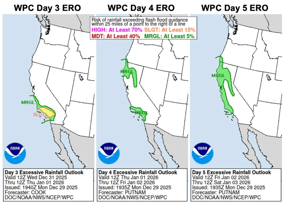
The Weather Prediction Center (WPC) has issued a Slight Risk (level 2 of 4) of excessive rainfall for parts of Southern California from early Thursday through early Friday, with Marginal Risk areas extending northward into the coastal ranges and Sierra foothills.
As the second system moves inland, heavy rain potential will shift toward northern and central California on Friday.
Local National Weather Service offices in Los Angeles and Oxnard expect rainfall totals of 25 to 75 mm (1 to 3 inches) for coasts and valleys and 75 to 125 mm (3 to 5 inches) in the mountains and foothills, warning of possible debris flows and rockslides on saturated slopes.
The San Francisco Bay Area office has issued a Coastal Flood Advisory from Wednesday morning through Sunday afternoon due to tidal flooding risks in low-lying areas, with rain returning midweek and persisting through the weekend.
Farther north, the Eureka office anticipates light rain on Wednesday and Thursday, followed by a stronger front on Friday, bringing moderate to heavy precipitation, gusty winds, and high-elevation snow over the interior ranges.
“A series of atmospheric rivers will bring an increased risk for urban and small stream flooding late this week and into this weekend,” meteorologists at the Eureka NWS office said. “Mainstem rivers will also likely rise sharply and will need to be monitored for possible flood stage exceedance.”
“Be on the lookout for watches, advisories, and warnings as this next heavy rain event unfolds. Stay alert and remember to never attempt to drive through water-covered roads. Water may be moving much faster than you think.”
With soils already saturated from recent storms, rapid runoff is likely where the heaviest rainfall occurs. South- and southwest-facing terrain in Santa Barbara, Ventura, and Los Angeles counties will be most exposed during the first system, while coastal northern California faces similar conditions during the second.
More than 50% of ECMWF ensemble (EPS) members are forecasting 10-day precipitation totals >10% of normal annual precipitation (~50 mm / 2 inches) in the Los Angeles watershed.
References:
1 Multiple storms are forecast to bring precipitation to California later this week – CW3E – December 29, 2025
I'm a dedicated researcher, journalist, and editor at The Watchers. With over 20 years of experience in the media industry, I specialize in hard science news, focusing on extreme weather, seismic and volcanic activity, space weather, and astronomy, including near-Earth objects and planetary defense strategies. You can reach me at teo /at/ watchers.news.
Commenting rules and guidelines
We value the thoughts and opinions of our readers and welcome healthy discussions on our website. In order to maintain a respectful and positive community, we ask that all commenters follow these rules.