
NWS warns of severe thunderstorms and flash flooding across central states
A slow-moving storm system is tracking across the central United States and will continue through the weekend, bringing widespread showers and thunderstorms from the Great Lakes to the Mid-South. The National Weather Service (NWS) has issued Slight Risk areas for severe thunderstorms and excessive rainfall on Saturday, October 18, 2025, extending from the Ozarks into the mid-Mississippi River Valley, with potential for damaging winds, large hail, isolated tornadoes, and flash flooding.
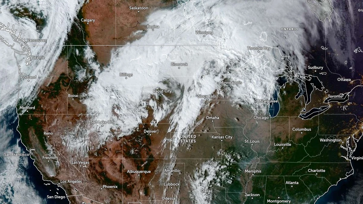
Satellite image of United States acquired at 21:30 UTC on October 16, 2025. Credit: NOAA/GOES-East, Zoom Earth, The Watchers
A broad low-pressure system centered over the Dakotas is lifting northeast across western Ontario through Friday evening, October 17, maintaining a trailing frontal boundary over the Upper Midwest and western Great Lakes.
Then, a new surface low is forecast to develop along this front over Wisconsin and Michigan on Saturday, becoming the main driver of active weather across the central United States through the weekend.
Showers and thunderstorms are increasing in coverage from Arkansas to eastern Michigan along and ahead of a strong cold front, with the heaviest rainfall expected from central Illinois to northern Indiana, where accumulations of 25–75 mm (1–3 inches) could lead to localized flooding, particularly where thunderstorms repeatedly track over the same areas.
Farther south, from the ArkLaTex region through western Kentucky, the Storm Prediction Center (SPC) has highlighted a Slight Risk for severe thunderstorms on Saturday. A combination of strong wind shear and high instability is expected to support the development of storms capable of producing damaging winds, large hail, and isolated tornadoes. A Marginal Risk extends northward into the Ohio Valley.
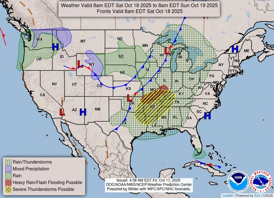
Behind the system, cooler and drier air will spread across the central Plains and Midwest by Sunday as high pressure builds in from the west. The transition is expected to bring a sharp temperature drop following the passage of the cold front.
Elsewhere, a Pacific storm system approaching the Northwest will bring rain and mountain snow to Washington state late Saturday, along with increasing winds across northern Montana. Across the eastern United States, high pressure continues to maintain clear and cool conditions, with frost and freeze warnings in effect for interior portions of the Mid-Atlantic and Northeast.
The combination of frontal lifting, moisture transport from the Gulf of Mexico, and favorable upper-level dynamics is expected to maintain widespread convection and heavy rainfall through early Sunday, before the system weakens while moving into the Great Lakes and southern Ontario.
References:
1 Short Range Forecast Discussion – NWS/WPC – October 17, 2025
I'm a dedicated researcher, journalist, and editor at The Watchers. With over 20 years of experience in the media industry, I specialize in hard science news, focusing on extreme weather, seismic and volcanic activity, space weather, and astronomy, including near-Earth objects and planetary defense strategies. You can reach me at teo /at/ watchers.news.
Commenting rules and guidelines
We value the thoughts and opinions of our readers and welcome healthy discussions on our website. In order to maintain a respectful and positive community, we ask that all commenters follow these rules.