
Dangerous rip currents expected along U.S. East Coast as Hurricane Erin grows in size
Tropical Storm Erin is forecast to grow substantially over the western Atlantic this week, producing dangerous surf, rip currents, and a possible storm surge of 0.6 to 1.2 m (2–4 feet) from Cape Lookout to Duck, North Carolina, as it approaches the U.S. East Coast, the Bahamas, Bermuda, and Atlantic Canada.

Satellite image of Hurricane Erin at 08:30 UTC on August 19, 2025. Credit: NOAA/GOES-East, RAMMB/CIRA, The Watchers
- Erin is expected to produce life-threatening surf and rip currents along the beaches of the Bahamas, much of the east coast of the U.S., Bermuda, and Atlantic Canada during the next several days. Beachgoers in those areas should follow advice from lifeguards, local authorities, and beach warning flags.
- Tropical storm conditions and coastal flooding are possible in the North Carolina Outer Banks beginning late Wednesday or Wednesday night where Tropical Storm and Storm Surge Watches are in effect. Interests in along the U.S. Mid-Atlantic and southern New England coasts and on Bermuda should also monitor the progress of Erin as strong winds are possible Thursday and Friday.
- Heavy rainfall from the outer bands of Erin will continue today for the Turks and Caicos and through tonight for the Bahamas. Flash and urban flooding are possible.
- Tropical storm conditions are expected in the Turks and Caicos Islands and in the southeast Bahamas for a few more hours. Tropical storm conditions are possible in portions of the central Bahamas today.
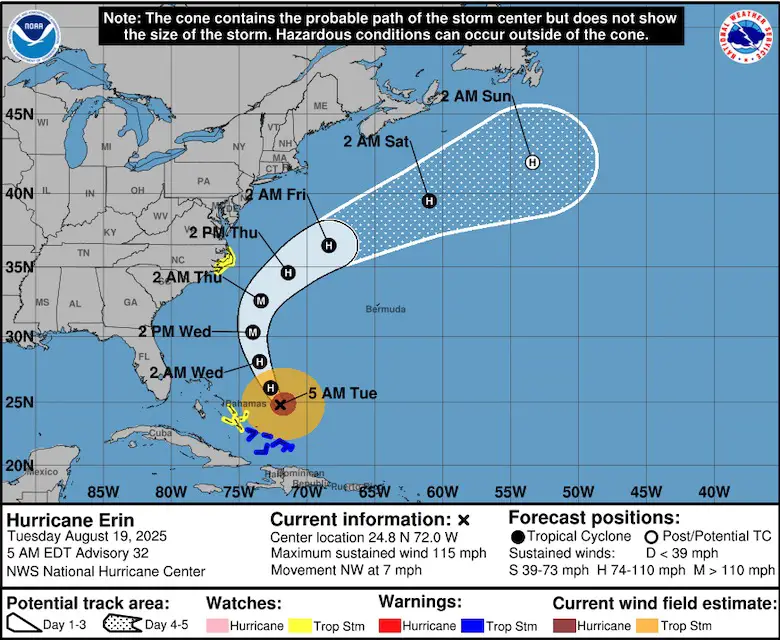
At 09:00 UTC (05:00 EDT) on August 19, Category 3 Hurricane Erin was located about 1 090 km (675 miles) southwest of Bermuda and 1 205 km (750 miles) south-southeast of Cape Hatteras, North Carolina.
The system had maximum sustained winds of 185 km/h (115 mph) at the time and was moving northwest at 11 km/h (7 mph) with a minimum central pressure of 955 mb.
On the forecast track, the center of Erin will pass to the east of the Bahamas today and tonight, August 19 and 20, and then move over the western Atlantic between the U.S. east coast and Bermuda on Wednesday and Thursday. Erin is expected to remain a major hurricane during this period.
A Tropical Storm Warning in effect for the Turks and Caicos Islands and the southeast Bahamas. A Tropical Storm Watch is in effect for the central Bahamas and Beaufort Inlet to Duck, North Carolina, including Pamlico Sound, while a Storm Surge Watch in effect from Cape Lookout to Duck, North Carolina, where surge heights of 0.6–1.2 m (2–4 feet) are possible.
Along the U.S. East Coast, Erin’s swells are forecast to generate waves of 5–10 m (15–25 feet) in exposed locations such as the Outer Banks and Cape Cod, and 3–5 m (10–15 feet) along parts of Long Island. Lifeguards in Wrightsville Beach, North Carolina, reported 50 water rescues on August 18 due to rip currents.
The National Hurricane Center warned that life-threatening surf and rip currents will affect the Bahamas, Bermuda, U.S. East Coast, and Atlantic Canada during the next several days.
In Puerto Rico, Erin’s outer bands brought torrential rainfall exceeding 350 mm (14 inches), landslides, and widespread power outages affecting hundreds of thousands. Authorities closed ports and cancelled flights in Puerto Rico and the U.S. Virgin Islands.
In North Carolina, states of emergency were declared for Dare and Hyde counties, including Hatteras and Ocracoke Islands. Mandatory evacuations were issued due to risks of flooding, coastal erosion, and overwash on Highway 12.
Bermuda is forecast to experience high surf and rip currents through August 21. In Atlantic Canada, southeastern Newfoundland may experience heavy rainfall and strong winds on August 22–23 as Erin transitions to a post-tropical cyclone. Longer-range forecasts suggest the system or its remnants may later impact Iceland or the United Kingdom.
Minor coastal flooding is possible in areas of onshore winds in the Turks and Caicos Islands and the southeast Bahamas. Near the coast, the surge will be accompanied by large waves.
The combination of a dangerous storm surge and the tide will cause normally dry areas near the coast to be flooded by rising waters moving inland from the shoreline.
The water could reach 0.6–1.2 m (2 to 4 feet) above ground from Cape Lookout to Duck, North Carolina if the peak surge occurs at the time of high tide.
The deepest water will occur along the immediate coast where the surge will be accompanied by large and dangerous waves. Surge-related flooding depends on the relative timing of the surge and the tidal cycle, and can vary greatly over short distances.

I’m a science journalist and researcher at The Watchers, contributing to the Epicenter edition, where I cover peer-reviewed scientific research and emerging discoveries across Earth and space sciences. With a background in astronomy and a passion for environmental science, I’ve worked in shark and coral conservation in Fiji, conducting reef and shark-behavior research, contributing to mangrove restoration, and earning PADI Open Water and Coral Reef Certifications. I bring a blend of scientific rigor and storytelling to illuminate the discoveries shaping our planet and beyond.
History lesson:
Hurricane Erin, was 500 miles off the NYC coastline. Guess the date?
9/11/2001.
She passed by at 9:39 am.
2025 Hurricane Erin, is on a similar path per spaghetti models.
Things that make you go hmmm.