
Typhoon Podul approaching Taiwan with potential for rapid intensification before landfall
Typhoon Podul is forecast to make landfall near Taitung City, southeastern Taiwan, on August 13, 2025, bringing heavy rainfall, strong winds, and coastal flooding across much of Taiwan, southern Japan, and northern Philippines over the next 48 hours. It is then expected to make a second landfall along the south-central coast of China and potentially penetrate deep inland.

Satellite image of Typhoon Podul at 09:20 UTC on August 12, 2025. Credit: JMA/Himawari-9, RAMMB/CIRA, The Watchers
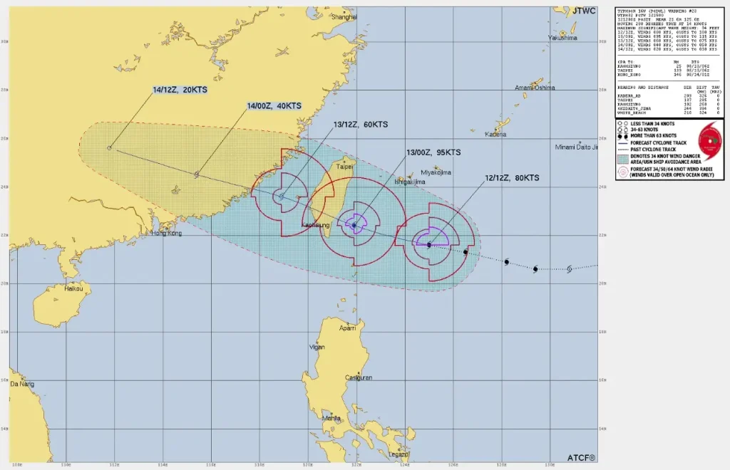
At 09:00 UTC (17:00 LT) on August 12, the center of Typhoon Podul was located about 700 km (435 miles) southeast of Taiwan’s eastern coast and 593 km (369 miles) south-southwest of Kadena Air Base, Okinawa.
The system was moving west-northwest at 30 km/h (19 mph) with maximum sustained winds of 130 km/h (81 mph) and significant wave heights of 8.8 m (29 feet).
Satellite imagery indicated a rapidly consolidating and compact typhoon with an emerging low-level eye structure. Sea surface temperatures of 29–31 °C (84–88 °F), low to moderate easterly vertical wind shear, and moderate westward outflow aloft are supporting further intensification.
Podul is expected to make landfall near Taitung around 12:00 LT (04:00 UTC) on August 13. Forecast guidance indicates the typhoon could reach a peak intensity of 185 km/h (115 mph) before landfall, with some models suggesting it may remain in the 175–185 km/h (109–115 mph) range.
The Taiwan Central Weather Administration (CWA) has issued land warnings for Hualien, Taitung, Pingtung, and Kaohsiung counties.
Rainfall totals in southern mountainous areas may reach 600 mm (23.6 inches) while eastern and central mountain ranges could exceed “extremely heavy rain” thresholds of 200 mm (7.9 inches) in 24 hours or 100 mm (3.9 inches) in 3 hours. The Central Weather Administration (CWA) has warned of landslides, debris flows, and flash flooding in these areas.
Hundreds of residents have already been evacuated from high-risk areas, including at least 700 people in Hualien County due to the potential overflow of a natural dam.
As of 17:00 LT, the radius of sustained gale-force winds was about 165 km (103 miles), with peak gusts up to 162 km/h (101 mph). Significant wave heights are forecast to exceed 4 m (13 feet) along most coasts and 6 m (20 feet) on eastern shores. Coastal flooding and hazardous seas are expected well ahead of the storm center.
Following landfall in Taiwan, Podul is expected to weaken rapidly over rugged terrain, emerging into the Taiwan Strait as a strong tropical storm. The system will then track toward the south-central coast of China between August 13–14, making a second landfall before weakening further and dissipating over the interior. Heavy rainfall and strong winds may extend far inland in China along its path.
In southern Japan’s Okinawa Prefecture and the northern Philippines, authorities have warned of high seas, heavy rain, and gusty winds over the next 48 hours.
I'm a dedicated researcher, journalist, and editor at The Watchers. With over 20 years of experience in the media industry, I specialize in hard science news, focusing on extreme weather, seismic and volcanic activity, space weather, and astronomy, including near-Earth objects and planetary defense strategies. You can reach me at teo /at/ watchers.news.
Commenting rules and guidelines
We value the thoughts and opinions of our readers and welcome healthy discussions on our website. In order to maintain a respectful and positive community, we ask that all commenters follow these rules.