
Powerful derecho brings destructive winds to South Dakota, Iowa, and Minnesota
A destructive derecho swept through the central United States from the evening of July 28 into early July 29, 2025, producing wind gusts up to 160 km/h (99 mph), toppling trees, and causing widespread power outages.
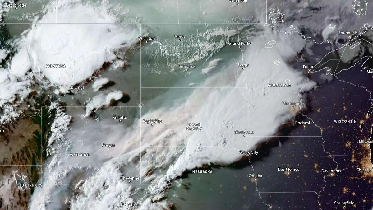
Image credit: NOAA/GOES-East, Zoom Earth, The Watchers. Acquired at 23:40 UTC on July 28, 2025
A powerful derecho developed over southern South Dakota late on July 28, producing embedded severe thunderstorms and isolated tornadoes.
The National Weather Service (NWS) confirmed peak measured wind gusts included 160 km/h (99 mph) in Sioux Center, Iowa, 148 km/h (92 mph) in Spencer, Iowa, 140 km/h (87 mph) in Irene, South Dakota, and 137 km/h (85 mph) in Parker, South Dakota.
Earlier in the evening, storm chasers documented tornadoes near Gregory, South Dakota, and in other parts of the state’s south.
The derecho then intensified as it moved east into Iowa and Minnesota, producing widespread destructive winds equivalent in force to a Category 2 hurricane.
In Hudson, South Dakota, video documented extensive tree and structural damage, including collapsed buildings. In Beresford, South Dakota, numerous trees were snapped or uprooted, power lines were brought down, and debris blocked several streets. Similar tree damage was reported across much of the impacted corridor.
Power outages peaked at more than 100 000 customers in Minnesota and just under 30 000 in Iowa. Many communities in South Dakota also experienced prolonged outages.
A destructive derecho brought hurricane-force wind gusts across the central US last night, snapping trees and knocking out power for thousands. This was the scene and damage in Beresford, South Dakota. pic.twitter.com/rhc5kZ7KIn
— AccuWeather (@accuweather) July 29, 2025
Utility crews began restoration work overnight, but some areas remained without service through Tuesday morning.
Derechos are defined as fast‑moving, long‑lived complexes of severe thunderstorms capable of producing sustained wind gusts above 93 km/h (58 mph) over hundreds of kilometers.
This event traveled from the northern Plains into the Upper Midwest along a cold front in a highly unstable air mass, also producing large hail in localized areas.
This video from FOX Weather Exclusive Storm Tracker @BrandonCopicWx shows significant tree damage in South Dakota after a powerful derecho tore across portions of the northern Plains and Midwest Monday night into Tuesday morning. More: https://t.co/vUh2JDQJhh pic.twitter.com/LVG5xxLAg9
— FOX Weather (@foxweather) July 29, 2025
On July 29, NOAA’s Storm Prediction Center maintained a Level 2 out of 5 severe weather threat for parts of Montana, Wyoming, South Dakota, Nebraska, Colorado, and Iowa, citing the potential for additional damaging wind gusts later in the day.

I’m a science journalist and researcher at The Watchers, contributing to the Epicenter edition, where I cover peer-reviewed scientific research and emerging discoveries across Earth and space sciences. With a background in astronomy and a passion for environmental science, I’ve worked in shark and coral conservation in Fiji, conducting reef and shark-behavior research, contributing to mangrove restoration, and earning PADI Open Water and Coral Reef Certifications. I bring a blend of scientific rigor and storytelling to illuminate the discoveries shaping our planet and beyond.
Commenting rules and guidelines
We value the thoughts and opinions of our readers and welcome healthy discussions on our website. In order to maintain a respectful and positive community, we ask that all commenters follow these rules.