
Critical fire weather, red flag warnings issued for parts of Nevada, Idaho, and Utah
Red flag warnings are in effect across parts of Nevada, Idaho, and Utah on July 15, 2025, due to strong winds, dry fuels, low humidity, and scattered dry thunderstorms.

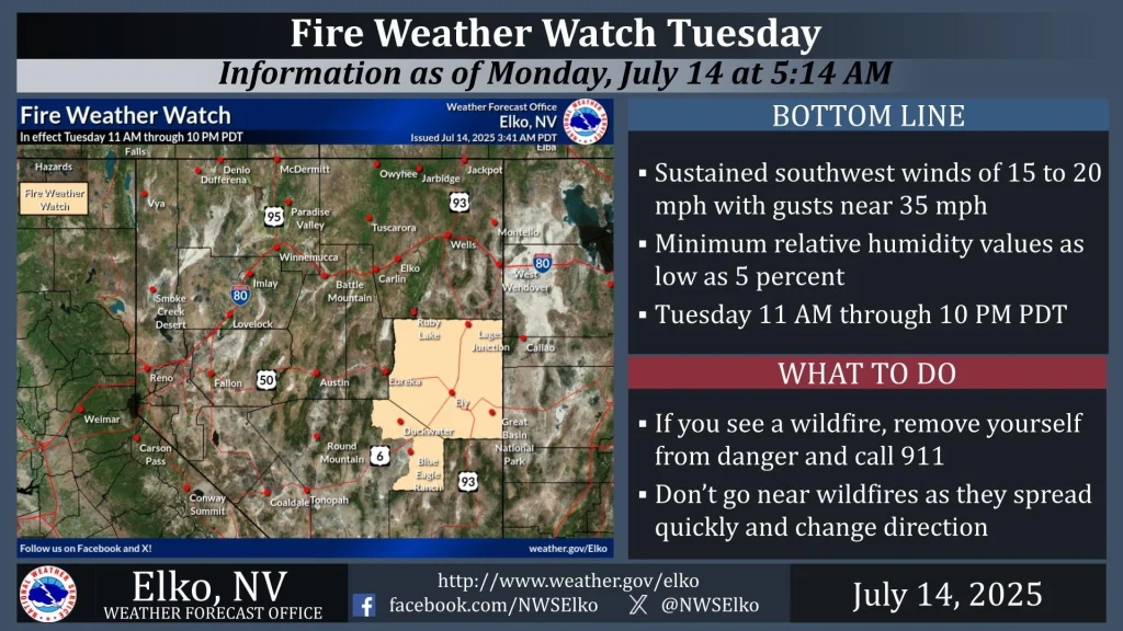
Image credit: NWS
Red flag warnings have been issued for large portions of Nevada, Idaho, and Utah on Tuesday, July 15, in response to a combination of low relative humidity, gusty winds, and lightning from dry thunderstorms expected to ignite and spread wildfires rapidly.
In eastern-central Nevada (Fire Weather Zone 425), the National Weather Service (NWS) in Elko has warned of southwest winds from 16–32 km/h (10–20 mph), gusting up to 56 km/h (35 mph), with relative humidity of 5–10%. This warning remains in effect from 11:00–22:00 local time (LT).
In eastern Elko County (Zone 470), a separate Red Flag Warning is in place for scattered dry thunderstorms accompanied by gusty outflow winds reaching up to 80 km/h (50 mph). Dry lightning and wind-driven fire spread are the primary concerns in this region.
The NWS Las Vegas has issued a similar warning for Lincoln and Nye Counties (Fire Weather Zone 461) from 11:00–22:00 LT, forecasting south winds of 24–40 km/h (15–25 mph) with gusts to 48 km/h (30 mph) and humidity levels of 7–14%.
In southeastern Idaho, including Fire Weather Zones 410, 411, 413, and 427, Red Flag Warnings are active from 12:00–21:00 LT. According to the NWS Pocatello, scattered thunderstorms with 25–45% coverage are expected. These storms may generate outflow winds exceeding 64–80 km/h (40–50 mph), with locally higher gusts reaching around 97 km/h (60 mph). Relative humidity values are forecast to drop as low as 15–25%. Lightning-induced fire starts and rapid spread are the main risks.
The NWS Salt Lake City has issued multiple warnings across Utah, covering Fire Weather Zones 478 through 498. These include the Salt Lake Desert, Wasatch Mountains, Central Utah West Desert and Mountains, Color Country Mountains and West Desert, Mojave Desert, and the Grand Staircase region. The warnings are in effect from 12:00–23:00 LT on July 15.
Conditions include southwest winds of 16–32 km/h (10–20 mph), gusting up to 48 km/h (30 mph), relative humidity values as low as 9%, and scattered dry thunderstorms capable of producing frequent lightning and strong outflow winds. Forecast models indicate a 40–50% probability of gusts exceeding 72 km/h (45 mph) within storm outflows.
The NWS warns that these factors will create an environment conducive to rapid wildfire ignition and spread. Agencies are advising against all outdoor burning and urging residents to remain prepared for potential fire ignition and spread.
References:
1 Red Flag Warning – NWS – July 14, 2025

I’m a science journalist and researcher at The Watchers, contributing to the Epicenter edition, where I cover peer-reviewed scientific research and emerging discoveries across Earth and space sciences. With a background in astronomy and a passion for environmental science, I’ve worked in shark and coral conservation in Fiji, conducting reef and shark-behavior research, contributing to mangrove restoration, and earning PADI Open Water and Coral Reef Certifications. I bring a blend of scientific rigor and storytelling to illuminate the discoveries shaping our planet and beyond.
Commenting rules and guidelines
We value the thoughts and opinions of our readers and welcome healthy discussions on our website. In order to maintain a respectful and positive community, we ask that all commenters follow these rules.