
SPC warns of significant severe weather outbreak from the southern Plains into the Ozarks
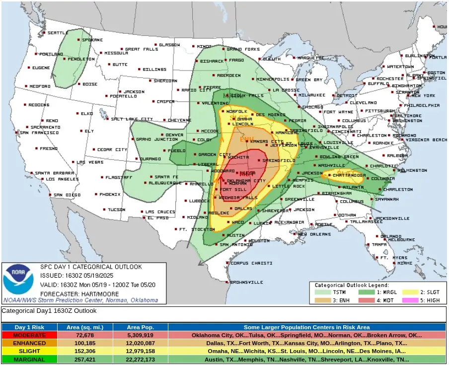
A significant severe weather outbreak is expected across far north Texas, much of central and eastern Oklahoma, southeast Kansas, and the Ozarks from the afternoon of May 19, 2025, into the night. The Storm Prediction Center (SPC) issued a Moderate Risk warning for this region, with the potential for strong tornadoes, very large hail, and damaging winds.
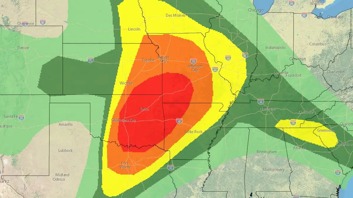
Convective Outlook for May 19, 2025. Credit: NWS/SPC
A major severe weather event is forecast to unfold from the central and southern Plains into the Ozarks, United States, from the afternoon of May 19 into the overnight hours.
The National Weather Service’s Storm Prediction Center (SPC) has issued a Moderate Risk level, indicating the potential for significant hazards including tornadoes, large hail, and damaging winds.
The synoptic setup involves a powerful upper-level trough emerging from the southern Rockies, with a 70–80 knot mid-level jet entering Oklahoma. Meanwhile, a surface low is expected to deepen over northwest Oklahoma, enhancing southerly low-level flow across the warm sector. Dew points approaching 21°C (70°F) and strong surface heating east of an advancing dryline will create extreme instability across parts of Texas, Oklahoma, and Kansas.
Forecast soundings indicate an environment highly favorable for supercell development. In eastern Oklahoma, western Arkansas, and southwest Missouri, large-scale ascent from a southern stream shortwave trough is likely to initiate widespread convection by early afternoon.
The parameters support all severe weather modes, including strong to intense tornadoes.

The highest concern is focused within the Moderate Risk zone, covering approximately 188 285 km2 (72 678 mi2) and affecting a population of over 5.3 million. Major urban centers under this elevated threat include Oklahoma City, Tulsa, Springfield, Norman, and Broken Arrow. The probability of strong to intense tornadoes, very large hail, and destructive wind gusts is considerably heightened in this area.
The Enhanced Risk region encompasses 259 470 km2 (100 185 mi2) with a population of nearly 12 million, including densely populated metropolitan zones such as Dallas, Fort Worth, Kansas City, Arlington, and Plano.
Further west, along a dryline extending from west-central Oklahoma to central Kansas, discrete supercells are expected to develop in mid-to-late afternoon. These storms will form in an uncapped and highly unstable air mass, with sufficient deep-layer shear to support strong tornadoes and very large hail.
To the north, in northeast Kansas and southeast Nebraska, storm development will be influenced by the approach of a Pacific cold front. Although forcing may favor more linear storm structures, the potential for embedded supercells remains, posing a continued risk for large hail and isolated tornadoes.
A separate slight risk zone extends into parts of the southeastern U.S., from east Tennessee into South Carolina, where isolated severe storms are also possible.
SPC is urging residents in the outlined regions to review their severe weather safety procedures for the possibility of dangerous weather today and remain alert for watches and warnings via NOAA Weather Radio, weather.gov, or other reliable media outlets.
A watch means that conditions are favorable for severe thunderstorms over the next several hours. If a severe thunderstorm warning is issued for your area, move to a place of safety, ideally in an interior room on the lowest floor of a sturdy building.
I'm a dedicated researcher, journalist, and editor at The Watchers. With over 20 years of experience in the media industry, I specialize in hard science news, focusing on extreme weather, seismic and volcanic activity, space weather, and astronomy, including near-Earth objects and planetary defense strategies. You can reach me at teo /at/ watchers.news.
This weather modification and cloud seeding needs to stop. Oregon has been doing it since 2024. Central Oregon is famous for it’s sunny clear weather year around. Since early fall if 2024 we have not had one fully clear sunny day. We have mostly gray cool days now. This is causing the need for more energy to stay warm. We should be in the 70’s during the days and instead we have been in the 50’s and low 60’s . Governor Kotek is allowing this again with no say or vote by the citizens of Oregon. When we see the terrible storms we are seeing in other parts of the country it seems obvious that weather modification is being done and is causing severe damage. President Trump needs to put a stop to this. We are having far to many major storms for this to be natural. Are they trying to drive people out of some areas of America? What is the silver oxide (dry ice) they are releasing doing to pollinators and other wildlife? What is it doing to the soil and water sources? This needs to be investigated and brought to the forefront.