
Severe thunderstorms forecast for parts of Texas, Oklahoma, and the northeastern U.S. as powerful storm system moves east
A powerful storm system will move across the northeastern United States through Tuesday, April 29, 2025, prompting Enhanced Risk areas for severe thunderstorms across parts of Texas and Oklahoma in the south-central U.S., and from the Ohio Valley into the interior Northeast.
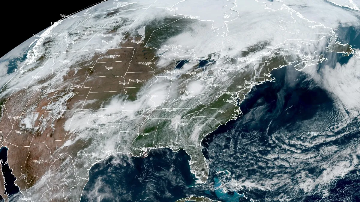
Image credit: NOAA/GOES-East, RAMMB/CIRA, The Watchers. Acquired at 19:10 UTC on April 29, 2025
An elongated low pressure system moving from the Upper Great Lakes into southern Canada is forecast to produce severe thunderstorms across the Northeast and the Ohio Valley through Tuesday, April 29.
Thunderstorms are forecast to develop ahead of the cold front associated with the system. Severe thunderstorms producing damaging wind gusts and hail are expected across much of the Northeast and the Great Lakes region through Tuesday. The cold front is forecast to clear the Northeast by Wednesday morning, ending the threat of severe thunderstorms. Behind it, cooler and drier air will move in from the Great Lakes, bringing a colder start to Thursday under high pressure.
A portion of the cold front is forecast to stall across the Southern Plains through Tuesday night before lifting northeastward on Wednesday as a warm front.
The system is expected to produce 50 to 100 mm (2 to 4 inches) of heavy rain from northern Texas into parts of Oklahoma and the mid-Mississippi Valley through Tuesday into Wednesday, April 30, as the nearly stationary front persists over the region. Given saturated ground from recent rainfall, this new round could lead to significant flash flooding.
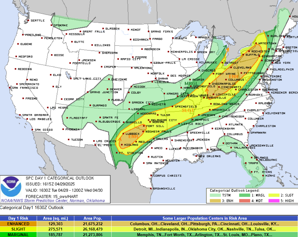
The Storm Prediction Center (SPC) has issued an Enhanced Risk for severe thunderstorms across parts of Texas, Oklahoma, Ohio, Pennsylvania, and Kentucky through Tuesday.
The Weather Prediction Center (WPC) has issued a Moderate Risk (level 3 out of 4) for heavy rain across the region through Wednesday.
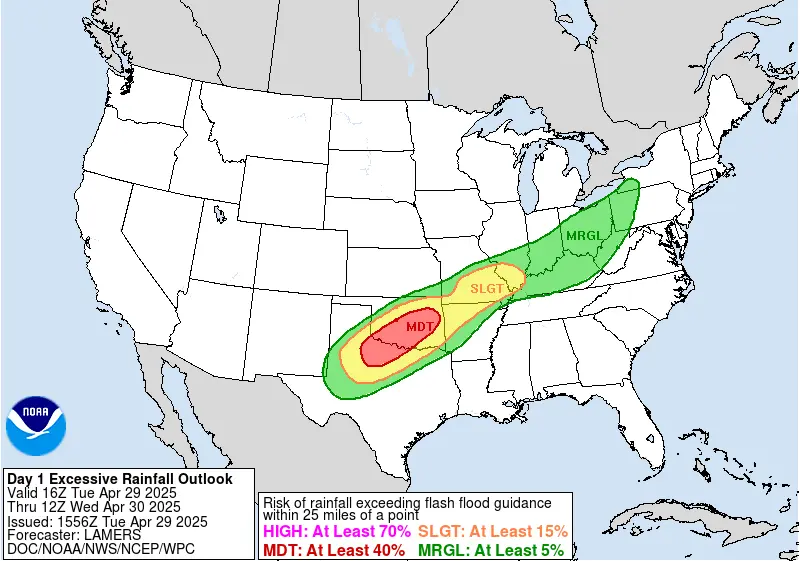
The barrage of severe weather that has battered the region over the past weeks has saturated the soil, meaning even low rainfall could trigger significant flash floods across the region.
The risk of heavy rain and flash flooding will shift eastward from the southern Plains toward the western Ozarks of Arkansas on Wednesday. The WPC has issued a Moderate Risk for rainfall capable of triggering flash floods in the region.
Repeated rounds of strong to severe thunderstorms, a pattern known as “training”, are expected to affect parts of the western Ozarks on Wednesday. This increases the risk for flash flooding due to storms passing over the same areas multiple times.
A low pressure wave is forecast to form over the southern Plains by Wednesday night and track toward the Midwest through Thursday morning. This will end the threat of severe weather across the southern Plains as scattered showers and thunderstorms expand into the Midwest and Ohio Valley ahead of a warm front. The development will also support an eastward expansion of scattered thunderstorms into the Ohio Valley, where the SPC maintains a Slight Risk for severe weather through Thursday morning.
Meanwhile, a separate low pressure system is forecast to bring rain and high-elevation snow to the Pacific Northwest and northern Rockies beginning Tuesday. This system is expected to move into the central Rockies and Great Basin by early Thursday.

I am an Assistant Editor and Severe Weather & Science Journalist at The Watchers, specializing in real-time severe weather coverage, geophysical event reporting, and research-driven scientific analysis. You can reach me at rishav(at)watchers(.)news.
Commenting rules and guidelines
We value the thoughts and opinions of our readers and welcome healthy discussions on our website. In order to maintain a respectful and positive community, we ask that all commenters follow these rules.