
Multiple atmospheric river (AR) landfalls and heavy precipitation expected along the U.S. West Coast
An unsettled weather pattern is forecast to continue into next week, with multiple atmospheric rivers expected to bring heavy precipitation to the U.S. West Coast following a March 23 event that caused flooding and a landslide in British Columbia.
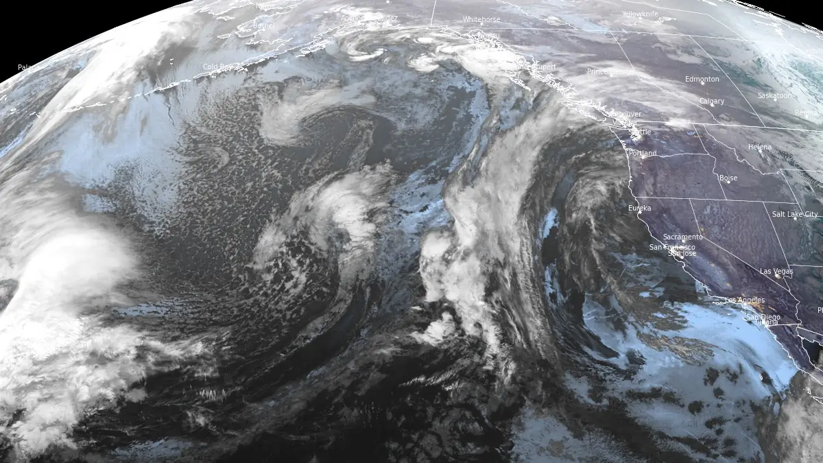
Image credit: NOAA/GOES-West, RAMMB/CIRA, The Watchers. Acquired at 14:00 UTC on March 25, 2025
An AR that made landfall over the Pacific Northwest on March 23 brought heavy rain over Washington and parts of British Columbia, causing localized floods and a landslide in B.C.’s Port Coquitlam. The highest rainfall was registered at the Cape Beale Lighthouse on Vancouver Island’s west coast at 130 mm (5.11 inches) in 48 hours.
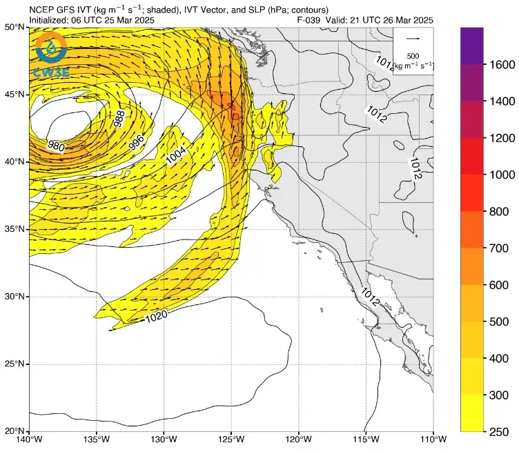
Following a brief respite, another AR associated with a strong low-pressure system is projected to make landfall along the U.S. West Coast on Wednesday, March 26, bringing moderate AR conditions (Integrated Vapor Transport, IVT, ≥500 kg/m/s) to coastal Oregon.
As the low-pressure system stalls offshore, strong cyclonic flow around the storm may prolong AR conditions (IVT ≥250 kg/m/s) into March 28.
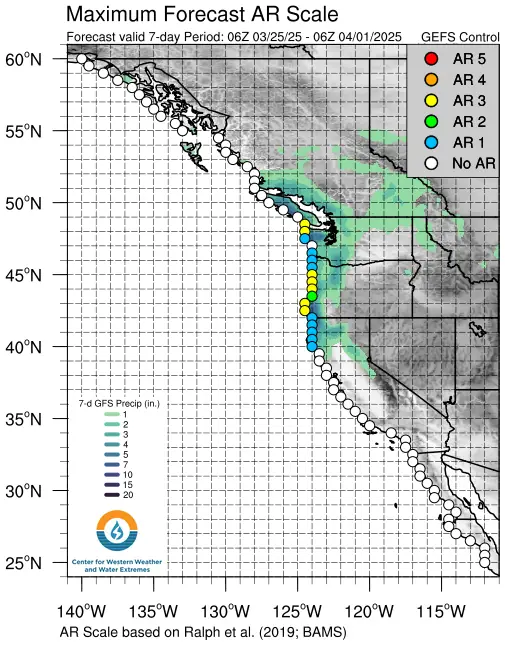
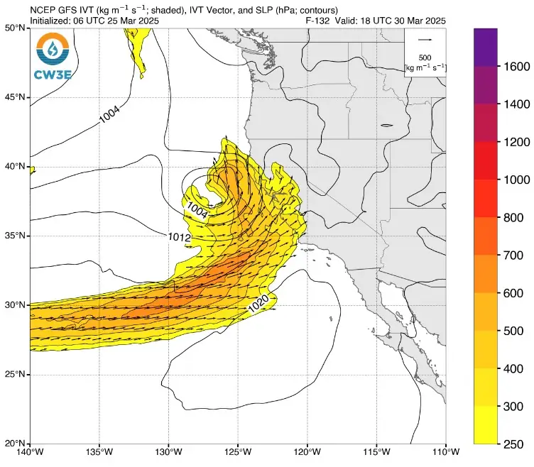
A third AR is forecast to make landfall over California on Sunday, March 30, though there is considerable uncertainty at this time regarding its location, magnitude, and orientation. The Global Forecast System (GFS) predicts AR landfall over Central California with stronger, southwesterly IVT, whereas the European Centre for Medium-Range Weather Forecasts (ECMWF) anticipates landfall over Southern California with weaker, westerly IVT.
The Center for Western Weather and Water Extremes’ (CW3E) AR Landfall Tool, based on the Global Ensemble Forecast System (GEFS), indicates a very high likelihood (>90% probability) of AR conditions over coastal Washington, Oregon, and far Northern California in association with the second AR on March 26. GEFS also shows a moderate-to-high likelihood (60–80% probability) of AR conditions over California on March 30 and April 1–2.
The ongoing AR is expected to produce an additional 25–50 mm (1–2 inches) of precipitation in the Olympic Peninsula and Washington Cascades. A marginal risk (≥5%; level 1 of 4) excessive rainfall outlook has been issued for these areas, valid through 05:00 PST on March 25.
The second AR is forecast to deliver at least 50–125 mm (2–5 inches) of precipitation to portions of western Washington, western Oregon, and far Northern California, with higher amounts possible in the Olympic Mountains and near the Oregon-California border.
Snowfall amounts over the next several days will be limited by anomalously warm temperatures and high freezing levels. Freezing levels in the Washington Cascades are forecast to rise to approximately 3 050 m (10 000 feet) ahead of the second AR landfall, then rapidly fall below 1 830 m (6 000 feet) as colder air moves into the region behind the AR.
Uncertainty in AR activity this weekend and next week is contributing to significant variability in forecast precipitation across Northern and Central California over the next 10 days.
While the GEFS and ECMWF ensemble means both project over 100 mm (4 inches) of total mean areal precipitation in the Upper Yuba watershed, the spread in ensemble forecasts is considerable, with some members predicting less than 50 mm (2 inches) and others exceeding 175 mm (7 inches).
References:
1 Quick Look at Storms Forecast to Impact US West Coast This Week into Next Week – CW3E – March 24, 2025
I'm a dedicated researcher, journalist, and editor at The Watchers. With over 20 years of experience in the media industry, I specialize in hard science news, focusing on extreme weather, seismic and volcanic activity, space weather, and astronomy, including near-Earth objects and planetary defense strategies. You can reach me at teo /at/ watchers.news.
Commenting rules and guidelines
We value the thoughts and opinions of our readers and welcome healthy discussions on our website. In order to maintain a respectful and positive community, we ask that all commenters follow these rules.