
Blizzard conditions expected as significant winter storm moves through Central Plains and Midwest
A significant winter storm is forecast to sweep through the Central High Plains and Midwest starting Tuesday, March 18, 2025. Heavy snow rates and strong winds will create blizzard conditions across portions of this region, creating dangerous travel through Thursday, March 20.

Winter Storm Severity Index graphic. Image credit: NOAA/WPC
A strong winter storm is expected to develop across the Central High Plains on March 18, bringing heavy snow and strong winds. The storm will move east and northeast through the Midwest on March 19.
The strengthening storm system will move into the Central Plains on Tuesday, bringing heavy snowfall and strong winds. This combination is expected to result in blizzard conditions across parts of the Central Plains from Tuesday night through Wednesday.
Heavy snowfall rates combined with blowing snow are expected to cause significant travel disruptions in the affected regions. The National Weather Service (NWS) has advised residents to be prepared for possible travel changes from Tuesday night through March 20 across the Central Plains and the Midwest.
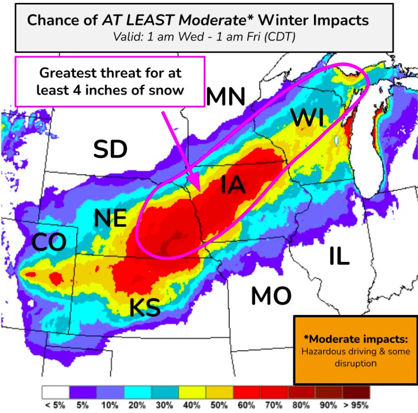
The storm will impact Colorado, Nebraska, Iowa, Wisconsin, Kansas, Missouri, Illinois, Minnesota, and parts of South Dakota. Nebraska, Iowa, and Kansas, along with parts of Minnesota, are expected to experience the most severe conditions, with approximately 10 cm (4 inches) of snowfall forecast in these areas.
On the eastern side of the system, light to moderate snowfall is expected over parts of the Northern Rockies, Northern Plains, and Upper Mississippi Valley on Monday. Snow will spread into the Northern and Central High Plains by Tuesday.
Light to moderate snowfall is also expected over the Central Plains, Upper Mississippi Valley, and Upper Great Lakes by Wednesday morning. Showers and thunderstorms are forecast south of the front across the Central Plains and Middle Mississippi Valley. Rain will also develop south of the storm’s boundary over parts of the Upper Great Lakes.
References:
1 Short Range Forecast Discussion – NWS – March 17, 2025

Rishav Kothari is Editor-in-Chief of The Watchers, where he runs the newsroom and covers earthquakes, volcanoes, severe weather and space weather.
Published in the last 24 hours
- Strong El Niño reinforces above-normal winter precipitation outlook across southern and eastern U.S.
- Scientists directly observe how submarine landslides unfold in western Canada Epicenter
- Odisha evacuated 983,642 people before Phailin crossed near Gopalpur on 12 October 2013 with winds of 200-210 km/h gusting to 220, and 44 died, against 9,885 in the 1999 super cyclone. Cyclone Akvan crossed the same coast on 20 November 2026. Epicenter
- Lava fountains reached 1,900 feet (580 m) at Kīlauea Iki in 1959, the highest ever recorded at Kīlauea, as USGS forecasts episode 57 fountaining at Halemaʻumaʻu for November 22-26. Epicenter
