
Successive storms to impact U.S. West Coast with rain and snow
Two atmospheric rivers (ARs) along with a low-pressure system are forecast to bring significant precipitation to much of the U.S. West Coast from March 8 to 14, 2025.

Satellite image of AR developing off the U.S. West Coast as of 10:10 UTC on March 8, 2025. Image credit: GOES-18, RAAMB/CIRA, The Watchers
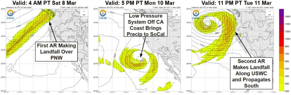
The first atmospheric river (AR) is forecast to make landfall over the Pacific Northwest (PNW) on Saturday, March 8, moving south along the coast through March 9. A trough is expected to follow behind the AR, bringing precipitation to Southern California from March 10 to 11, according to the Center for Western Weather and Water Extremes (CW3E).
The second AR is forecast to reach the U.S. West Coast on Wednesday, March 12, and move south along the California coast through March 13.
AR conditions (IVT ≥ 250 kg m⁻¹ s⁻¹) are forecast along the PNW coast on March 8 and 9 with the first AR, and along the West Coast on March 13 and 14 with the second AR.
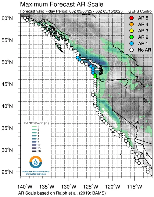
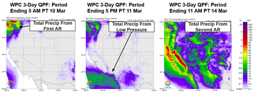
According to the Weather Prediction Center (WPC), 75–125 mm (3–5 inches) of precipitation is forecast over the Olympic Peninsula, while 75–100 mm (3–4 inches) is expected over the Washington Cascades from March 8 to 10 due to the first AR.
Around 25–50 mm (1–2 inches) of precipitation is forecast from March 10 to 12 as the low-pressure system moves over Southern California. More than 100 mm (4 inches) of precipitation is expected over California’s Coast Ranges, the Transverse Ranges, and the Sierra Nevada from March 12 to 14 due to the second AR.
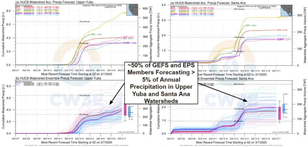
Significant uncertainty exists among ensemble members regarding the exact precipitation amounts, with predictions varying widely for both the Upper Yuba and Santa Ana watersheds. Forecasts indicate 50–225 mm (2–9 inches) of precipitation for Upper Yuba and 13–90 mm (0.5–3.5 inches) for the Santa Ana watershed.
Freezing levels over the Sierra Nevada are forecast to drop significantly from approximately 3 050– 3 660 m (10 000 –12 000 feet) to below 1 830 m (6 000 feet) as the week progresses and the second AR makes landfall. This decrease will raise the likelihood of heavy snowfall in addition to the forecasted high precipitation.
Unsettled weather along the U.S. West Coast is expected to persist into early March. The Climate Prediction Center (CPC) Days 8-14 Hazard Outlook indicates a moderate risk of heavy snow, heavy precipitation, strong winds, and flooding for Northern California and Western Oregon from March 14 to 16.
References:
1 Quick Look at Storms Forecast to Impact Western US – CW3E – March 7, 2025

I am an Assistant Editor and Severe Weather & Science Journalist at The Watchers, specializing in real-time severe weather coverage, geophysical event reporting, and research-driven scientific analysis. You can reach me at rishav(at)watchers(.)news.
Commenting rules and guidelines
We value the thoughts and opinions of our readers and welcome healthy discussions on our website. In order to maintain a respectful and positive community, we ask that all commenters follow these rules.