
Strong atmospheric river to impact California with heavy rain and mountain snow
A strong atmospheric river (AR) associated with a low-pressure system is set to impact California from Wednesday into Thursday, February 12 to 14, bringing heavy rain, mountain snow, and potential flooding. The National Weather Service (NWS) warns of significant precipitation and winter storm conditions, particularly in the Sierra Nevada and coastal mountain ranges.

Satellite image of atmospheric river approaching California. Image credit: NOAA/GOES-West, RAMMB/CIRA, The Watchers. Acquired at 23:50 UTC on February 10, 2025
- An atmospheric river associated with a low-pressure system will bring significant rainfall and mountain snow to California from February 12 to 14.
- Rainfall totals of up to 250 mm (10 inches) in mountain regions and 100 mm (4 inches) in lower elevations could lead to flooding, especially in areas with already elevated streamflow.
- More than 1.2 m (4 feet) of snow is forecast for the Central and Southern Sierra Nevada, with strong winds creating hazardous travel conditions.
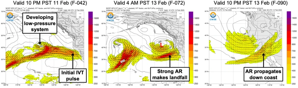
An atmospheric river (AR) associated with a low-pressure system is forecast to bring heavy rain and mountain snow to much of California from late Wednesday, February 12, through Friday, February 14.
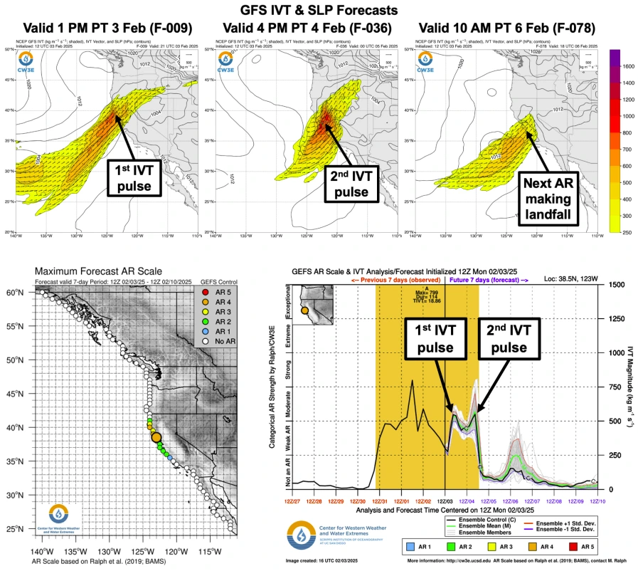
Before the AR arrives, a weak pulse of moisture transport will move onshore late Tuesday, February 11, bringing light precipitation to coastal Central and Southern California.
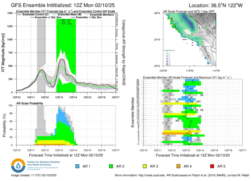
The GEFS control member forecasts AR 2 conditions over coastal Central California from Marin County to San Luis Obispo County and AR 1 conditions over coastal Southern California.
Most GEFS members predict a break in AR conditions between the initial pulse of moisture transport late Tuesday and the stronger pulse on Thursday.
Meanwhile, the EPS control member forecasts AR 3 conditions over San Diego County due to the absence of a break in AR conditions between the first and second pulses of moisture transport.

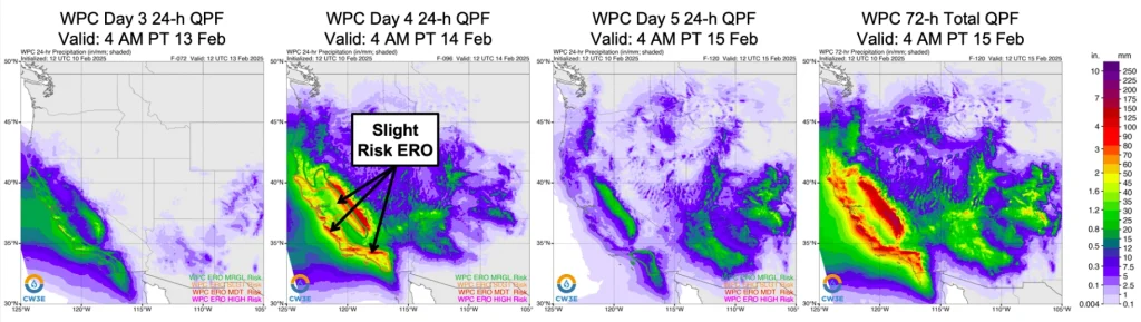
The heaviest precipitation and greatest impacts from this AR are expected in 24 hours from Thursday, February 13, into Friday, February 14. Precipitation totals of 75 – 150 mm (3 – 6 inches) are forecast for the Sierra Nevada, Central California Coast Ranges, and Transverse Ranges.
The NWS Weather Prediction Center (WPC) has issued a slight risk excessive rainfall outlook (ERO) for much of coastal California, the Central and Southern Sierra Nevada, and portions of the Central Valley.
Precipitation totals of 125 – 250 mm (5 – 10 inches) are likely in the Sierra Nevada, Central California Coast Ranges, and Southern California Transverse Ranges. About 50 – 100 mm (2 – 4 inches) of precipitation is forecast for lower elevation areas of Southern California.
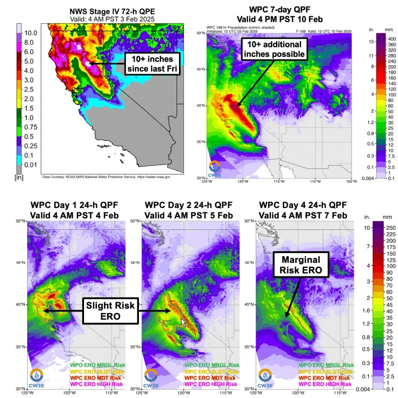
More than 1.2 m (4 feet) of snow is possible in the Central and Southern Sierra Nevada, with major to extreme winter storm impacts likely in these areas.
Fifteen stream gages are forecast to rise above the action stage, according to the California-Nevada Forecast Center, while five gages are expected to rise above the minor flood stage between Tuesday and Saturday, February 15.
Current streamflow is elevated over much of the Sacramento Valley due to heavy rainfall from recent ARs. This week’s rainfall is expected to cause additional flooding in the region.
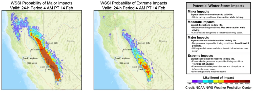
The combination of heavy snow and strong winds is expected to create hazardous conditions over the Sierra Nevada, especially from Thursday into Friday.
The WPC’s Winter Storm Severity Index (WWSI) shows an over 80% chance of major winter storm impacts over the Central and Southern Sierra Nevada. Meanwhile, higher terrain areas have an over 50% chance of extreme winter storm impacts.
References:
1 CW3E AR Update: 10 February 2025 Outlook – CW3E – February 10, 2025

I am an Assistant Editor and Severe Weather & Science Journalist at The Watchers, specializing in real-time severe weather coverage, geophysical event reporting, and research-driven scientific analysis. You can reach me at rishav(at)watchers(.)news.
Commenting rules and guidelines
We value the thoughts and opinions of our readers and welcome healthy discussions on our website. In order to maintain a respectful and positive community, we ask that all commenters follow these rules.