
Record rains, significant floods grip Dallas as cross country strom sweeps through Texas and Arkansas
A severe cross-country storm brought record rains and significant flooding to the Dallas-Fort Worth area through Thursday, January 30, 2025, leading to severe travel disruptions across the region. The storm also brought significant rain across Texas, Arkansas, and Oklahoma prompting several Flash Flood Warnings.
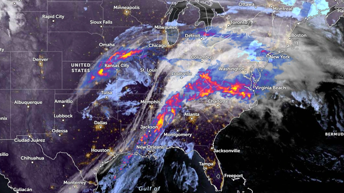
Satellite image of the cross country storm at 10:10 UTC on January 31, 2025. Image credit: NOAA-GOES-East, Zoom Earth, The Watchers
- A cross-country storm that caused heavy rainfall and flooding in Texas and Arkansas is now moving eastward, affecting multiple states, including Oklahoma and Louisiana.
- The storm brought 104 mm (4.1 inches) of rain in 24 hours, making it the second-highest daily total on record for the area. It also set new daily rainfall records for January 29 and 30.
- Several areas in Arkansas recorded over 127 mm (5 inches) of rain, leading to extensive flooding, with Pike County receiving the highest total of 156 mm (6.13 inches).
A cross-country storm is now moving eastward after causing heavy rainfall and severe flooding across Texas and Arkansas, with Oklahoma also reporting rainfall and minor flooding through Thursday and Friday morning, January 30 and 31.
The storm is expected to bring widespread rainfall to nearly 20 states as it moves eastward, prompting flood watches across multiple states.
The storm swept across the Dallas-Fort Worth region, bringing record rainfall, causing flooding across the area on Thursday, and leading to significant travel disruptions. Several roads were closed and crashes were reported across Texas.
Flooding had already impacted the Dallas area on Wednesday night, with drivers navigating flooded roads. Several Flash Flood and Thunderstorm Warnings were issued across Texas, including for cities such as Dallas, Arlington, and Plano.
Between Wednesday, January 29, and Thursday, the storm dropped 104 mm (4.1 inches) of rain in the Dallas-Fort Worth area, making it the second-highest 24-hour rainfall total on record. The highest 24-hour rainfall record for the area was set in 2012, when 108.5 mm (4.27 inches) of rain fell between January 24 and 25.
On Wednesday, 71 mm (2.8 inches) of rain was recorded, breaking the previous daily record set in 1999 when the region received 23.6 mm (0.93 inches). The storm also broke the single-day rainfall record for January 30, with 33.8 mm (1.33 inches) recorded on Thursday, surpassing the previous record of 31.5 mm (1.24 inches) set in 1982.
This was the first instance of back-to-back precipitation records for the area since August 21 – 22, 2022, according to the National Weather Service (NWS).
Higher rainfall totals were reported across other parts of Texas, with Rockwall recording up to 150 mm (5.9 inches) on Wednesday and Thursday, while Mesquite recorded 121 mm (4.77 inches).
Arkansas also experienced heavy rainfall starting Wednesday, leading to widespread flooding, with several areas recording over 127 mm (5 inches) of rain.
The heaviest rainfall was recorded in Pike County, where 156 mm (6.13 inches) of rain fell by 19:00 local time (LT) on Thursday at Langley Little Missouri River. Meanwhile, the Langley area recorded 143 mm (5.63 inches) by 13:00 on Thursday.
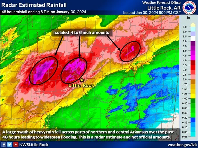
Clarksville in Johnson County recorded 137 mm (5.41 inches) of rain by 17:00 LT on Thursday, while Spadra Creek in Clarksville recorded over 127 mm (5 inches) by 20:15 LT. Several other regions across Arkansas recorded over 127 mm (5 inches) of rain, leading to statewide flooding.
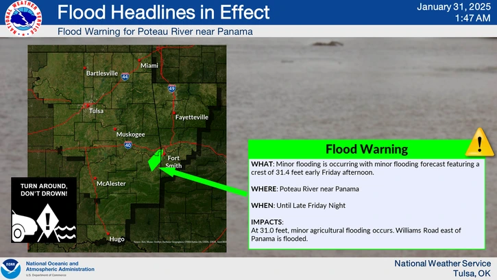
Oklahoma also reported flooding due to the storm, with the NWS issuing a Flood Warning for the Poteau River near Panama until Saturday afternoon. “Minor agricultural flooding is expected to occur, and Williams Road east of Panama is flooded,” said the NWS.
References:
1 Public Information Statement…Corrected –NWS – January 30, 2025

I am an Assistant Editor and Severe Weather & Science Journalist at The Watchers, specializing in real-time severe weather coverage, geophysical event reporting, and research-driven scientific analysis. You can reach me at rishav(at)watchers(.)news.
Commenting rules and guidelines
We value the thoughts and opinions of our readers and welcome healthy discussions on our website. In order to maintain a respectful and positive community, we ask that all commenters follow these rules.