
Heavy rainfall expected as second atmospheric river impacts Southern Oregon and Northern California
Cape Blanco stands in the crosshairs of AR3-level conditions today, as Southern Oregon and Northern California prepare for significant rain and rising flood risks.

Image credit: NOAA/GOES-West, RAMMB/CIRA, The Watchers. Acquired at 21:50 UTC on December 27, 2024
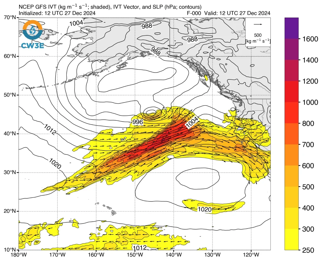
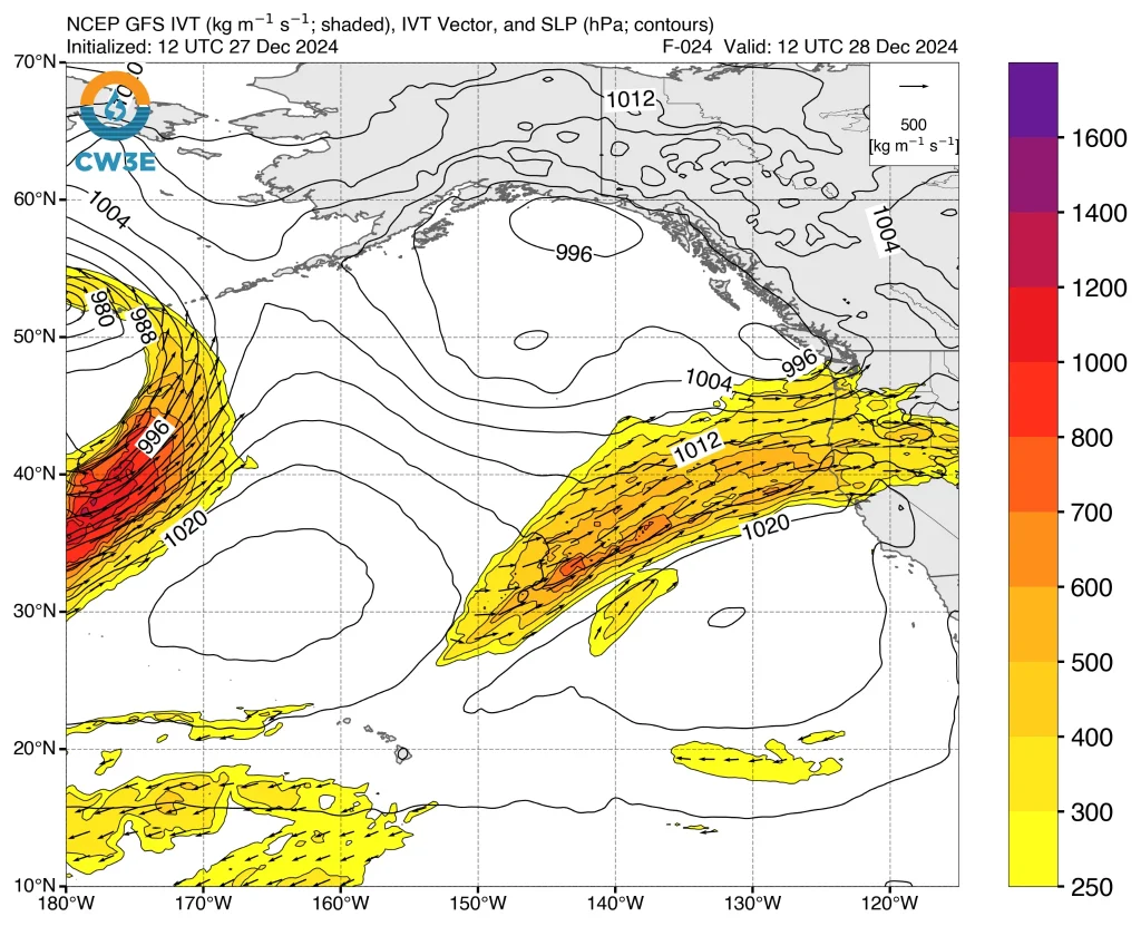
A weakening atmospheric river (AR) today will make way for a second AR that is forecast to bring impactful rainfall to Southern Oregon and Northern California over the next three days.
AR that made landfall on Friday, December 27 is forecast to shift south and weaken along the coast of California, with primarily northwesterly IVT over coastal California.
The second AR is forecast to move onshore later today, December 27 over coastal Oregon and Northern California with west-southwesterly IVT > 500 kg m-1 s -1 in the core of the AR, according to the Center for Western Weather and Water Extremes (CW3E).
CW3E is forecasting AR 2-3 conditions, based on the Ralph et al. 2019 AR Scale (1-5), over coastal Southern Oregon and Northern California, with high confidence in AR3 conditions near Cape Blanco in coastal Southern Oregon.
This atmospheric river event is expected to bring significant precipitation and hydrological impacts to the region over the next several days.
The NWS Weather Prediction Center (WPC) is predicting 24-hour precipitation totals ranging from 25 to 75 mm (1 to 3 inches) across Southern Oregon and Northern California over the next three days. The heaviest rainfall is expected between 04:00 LT on Saturday, December 28, and 04:00 LT on Sunday, December 29.
Additionally, 72-hour precipitation totals are forecasted to reach between 50 and 125 mm (2 to 5 inches) in these areas, with higher amounts of 180 to 250 mm (7 to 10 inches) over the Klamath Mountains and Northern California Coast Ranges.
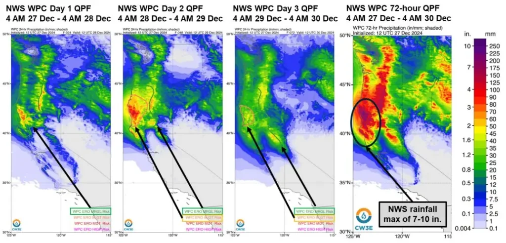


The NWS WPC has issued a slight risk (≥ 15%; level 2 of 4) excessive rainfall outlook (ERO) for the Klamath Mountains and Coastal Ranges of Southern Oregon and Northern California. A marginal risk (≥ 5%; level 1 of 4) ERO has also been issued, covering the area from the Washington/Oregon border to Northern California, extending to the northern Sierra Nevada during this period.
Quantitative precipitation forecasts from multiple models indicate high confidence in more than 10% of the normal annual precipitation occurring over the Upper Klamath watershed during the next three days due to this atmospheric river. These forecasts underscore the potential for substantial hydrological impacts in the region.
The NWS Northwest River Forecast Center (RFC) has projected one location to rise above moderate flood stage, four locations above minor flood stage, and 18 locations above action/bankfull stage over the next 10 days.
The NWS California-Nevada RFC is also forecasting one location to exceed minor flood stage and nine locations to reach action/monitor stage within the next five days.
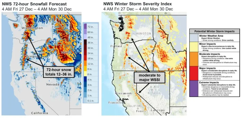
Freezing levels are anticipated to remain high throughout this atmospheric river event, limiting significant snowfall to the highest elevations. The NWS predicts 72-hour snowfall totals of 30 to 90 cm (12 to 36 inches) along the highest peaks of the Cascades and Northern Sierra Nevada.
Moderate to major Winter Storm Severity Index conditions are expected in isolated areas of these mountain ranges.
References:
1 Quick Look at the Weekend AR Activity and Impacts over the US West Coast – CW3E – December 27, 2024

I am an Assistant Editor and Severe Weather & Science Journalist at The Watchers, specializing in real-time severe weather coverage, geophysical event reporting, and research-driven scientific analysis. You can reach me at rishav(at)watchers(.)news.
Commenting rules and guidelines
We value the thoughts and opinions of our readers and welcome healthy discussions on our website. In order to maintain a respectful and positive community, we ask that all commenters follow these rules.