
Impossible travel, near blizzard conditions, and historic snowfall totals expected in parts of New Mexico and Colorado
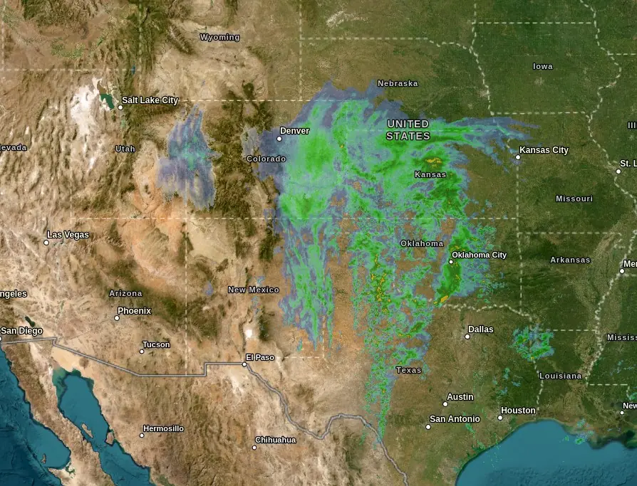
A severe winter storm impacting parts of Colorado and New Mexico is expected to bring additional heavy snowfall on Friday, November 8, 2024. Parts of the area had already accumulated 25 – 50 cm (10 – 20 inches) of snow by Thursday night, November 7, prompting the Colorado governor to declare a disaster emergency for what could be Denver’s most severe snowstorm in 30 years. Snowfall rates of 2.5 – 5 cm per hour (1 – 2 inches per hour) are anticipated to continue across the region, with total snow accumulations forecast to reach 30 – 120 cm (1 – 4 feet) in some areas.
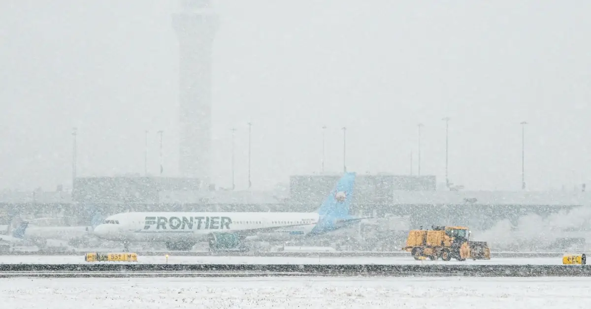
Image credit: Denver International Airport
- Heavy snowfall rates of 25 – 50 mm per hour (1 – 2 inches per hour) will continue through tonight across northeast New Mexico and eastern Colorado, with additional accumulations of 30 – 60 cm (1 – 2 feet) expected in the Sangre de Cristo Mountains, Raton Mesa, and surrounding areas.
- Historic snowfall totals of 90 – 120 cm (3 – 4 feet) are anticipated in parts of the Raton Mesa and Palmer Divide regions.
- Near-blizzard conditions will affect major highways, including the I-25 and I-70 corridors, resulting in low visibility, snow-covered roads, and prolonged closures; travel is not recommended.
- Strong winds and heavy snow are likely to cause scattered power outages and tree damage, impacting infrastructure in affected areas.
A severe winter storm affecting northeast New Mexico and eastern Colorado is forecast to continue producing snowfall rates of 2.5 – 5 cm per hour (1-2 inches per hour) through late Friday, November 8, with additional accumulations predicted between 30 – 60 cm (1 – 2 feet) in the Sangre de Cristo Mountains, Raton Mesa, and nearby foothills.
In localized areas within the Raton Mesa and Palmer Divide, total storm accumulation may reach historic 90 – 120 cm (3 – 4 feet), according to the NWS Weather Prediction Center. Snow is projected to taper off gradually by early Saturday, November 9.
Strong wind gusts combined with heavy snowfall will likely create near-blizzard conditions across several major highways, including the I-25 and I-70 corridors. These conditions are expected to lead to snow-covered roads, severely reduced visibility and prolonged road closures. Officials advise against travel in these areas due to nearly impossible driving conditions in some locations.
The weight of heavy snow, intensified by strong winds, is forecasted to result in scattered power outages and tree damage across the region, with potential impacts on infrastructure. Utility and transportation crews are preparing for extended road-clearing operations and service restoration where power outages and infrastructure damage may occur.
Denver, Colorado is currently experiencing what could be its largest November storm since 1994. Snowfall began affecting the region on Tuesday, November 5, starting at around 17:00 local time (LT) and continued until midday on Thursday.
Denver International Airport received 38 hours of steady snowfall between Tuesday and Thursday but heavy snowfall is forecast to affect the region again from Friday morning, lasting through midday Saturday. The region is expected to see over 41 cm (16 inches) of accumulated snowfall by Saturday.
Lincoln, Elbert, and Washington counties recorded between 25 – 50 cm (10 – 20 inches) of snow as of Thursday night. The Conifer area recorded approximately 52 cm (20 inches) in 24 hours from Tuesday evening to Wednesday, November 6, while the Elizabeth area reported 43 cm (17 inches) in the same period.
A winter storm warning has been issued for the Denver metro area, the southeastern suburbs, and the eastern plains. The warning is in effect from 05:00 LT on Friday until Saturday noon.
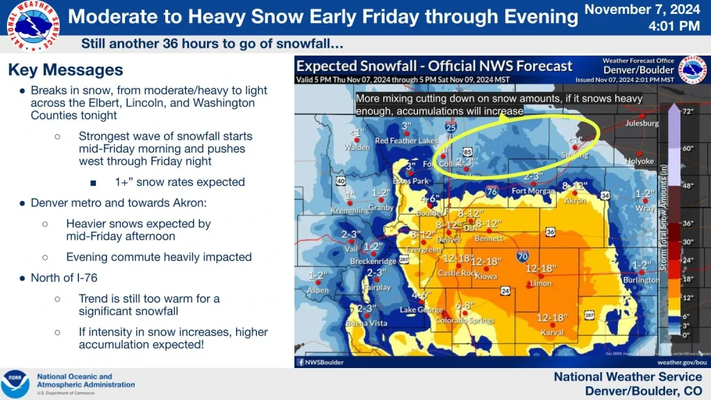
The highest snowfall totals are expected along Interstate 70 near Limon, Hugo, Agate, Punkin Center, and Karval, with an additional 30 – 50 cm (12 – 20 inches) of snow expected by Saturday.
The Denver metro area could receive 15 – 30 cm (6 – 12 inches) of additional snow by Saturday, while Castle Rock, Highlands Ranch, Kiowa, Parker, and Elizabeth could receive an additional 18 – 35 cm (7 – 14 inches) during the same period.
The Palmer Divide and east-central plains will see the heaviest snow with up to 30 – 48 cm (12 – 19 inches) possible. Commutes could be impacted by heavy snowfall on Friday.
A band of snow is forecast to move through Denver across I-76 towards Boulder & Greeley at around 02:00 LT. Rain & snow showers will also move north through Yuma County and towards Holyoke and Julesburg. Little impact on roads is expected in these areas, though a little slush is possible, said the National Weather Service (NWS).
Governor Jared Polis declared a “Disaster Emergency” on Thursday and authorized unarmed Colorado National Guard members to provide winter storm response support. The declaration also activates the Colorado State Emergency Operations Center and the State Emergency Operations Plan and directs the Office of Emergency Management (OEM) to take all necessary and appropriate State actions to assist the affected jurisdictions with their response, recovery, and mitigation efforts.
The Colorado Department of Transportation (CDOT) advised motorists to avoid traveling east of Interstate 35 and south of Interstate 76 to the New Mexico and Kansas state lines through Saturday.
Several road closures are anticipated, including Interstate 70 and 25.
“Drivers should be prepared for long-term closures and should avoid driving in the most impacted areas of the state for the duration of the storm,” said John Lorme, Director of Maintenance and Operations at CDOT.
References:
1 Colorado National Guard activated, disaster emergency declared for severe winter storm – KDVR – November 7, 2024
2 Another snowstorm set to bury Denver, could paralyze travel across Colorado’s Eastern Plains – CBS – November 7, 2024
3 This epic snowstorm could be Denver’s biggest in November in decades. Does it mean a snowy winter is ahead? – Denver 7 – November 7, 2024
4 Governor Polis Declares Disaster Emergency and Deploys Colorado National Guard to Provide Weather Support, State Employees Will Telework Along the Front Range With Some Regional Facility Closures – Colorado Governor – November 7, 2024

I am an Assistant Editor and Severe Weather & Science Journalist at The Watchers, specializing in real-time severe weather coverage, geophysical event reporting, and research-driven scientific analysis. You can reach me at rishav(at)watchers(.)news.
Commenting rules and guidelines
We value the thoughts and opinions of our readers and welcome healthy discussions on our website. In order to maintain a respectful and positive community, we ask that all commenters follow these rules.