
Southcentral Alaska sees first major snowfall of 2024/25 season, multiple warnings and advisories in effect
The first major snowfall of the 2024/25 winter season arrived in Southcentral Alaska on Monday, October 28, 2024, prompting authorities to issue multiple warnings and advisories.

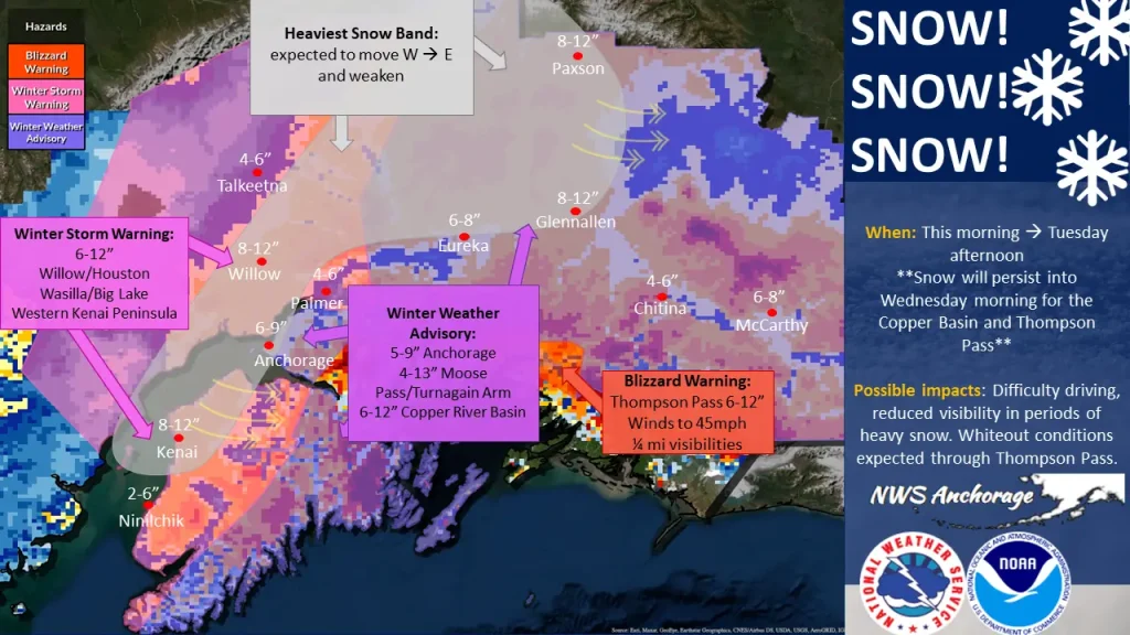
Image credit: NOAA/GOES-West, Zoom Earth, The Watchers. Acquired at 04:30 UTC on October 29, 2024
- Snow is expected to persist into Wednesday morning (LT), October 30 for the Copper Basin and Thompson Pass where a Blizzard Warning is in effect.
- Possible impacts include difficulty in driving, reduced visibility in periods of heavy snow, and whiteout conditions through Thompson Pass.
The National Weather Service (NWS) office in Anchorage has issued multiple warnings and advisories to highlight expected snowfall amounts through Wednesday, October 30.
A Winter Storm Warning is in effect for Willow/Houston, Wasilla/Big Lake, and the Western Kenai Peninsula, where the heaviest snow bands are expected to move from west to east and weaken. The NWS forecasts 15 – 30 cm (6 – 12 inches) of snowfall for this region.
A Winter Weather Advisory is in effect for Anchorage, where 13 – 23 cm (5 – 9 inches) of snow is expected; Moose Pass/Turnagain Arm, with a forecast of 10 – 33 cm (4 – 13 inches); and the Copper River Basin, where 15 – 30 cm (6 – 12 inches) of snow is forecast.
A Blizzard Warning is in effect for Thompson Pass, where 15 – 30 cm (6 – 12 inches) of snow is expected, accompanied by winds up to 72 km/h (45 mph) and visibility reduced to approximately 400 m (0.25 miles).
The first snowfall was recorded in western Anchorage (population 284 000) on Monday, with police reporting 25 car accidents and over a dozen vehicles in distress.
Authorities are urging motorists to clear snow from windshields, headlights, and taillights before driving and to reduce speed on area roads.
Elsewhere across the country, a strong storm system developing over the Great Basin will bring another round of mountain snow to portions of the central and northern Rockies from Tuesday into Wednesday. Initial warmth ahead of the storm will lead to fairly high snow levels, but colder air following a potent cold front will quickly bring snowfall accumulation down to around 2 400 m (8 000 feet) by Tuesday afternoon and night.
Snowfall totals will be bolstered by a significant influx of Pacific moisture, resulting in widespread accumulations of 15 – 30 cm (6 – 12 inches) with locally higher amounts across the mountainous areas of Wyoming, Colorado, and Utah.
Those traveling across high mountain passes should check the forecast before traveling and prepare for winter driving conditions.
In the wake of the storm, freeze concerns will return to some of the lower elevations of Utah and Colorado from Tuesday night into Wednesday morning as a much colder air mass settles into the region.
As the cold front advances eastward into the Plains, an environment featuring warm, moisture-rich air ahead of and along the front will create conditions for potential strong and severe thunderstorms on Tuesday, with increased likelihood on Wednesday.
Thunderstorms with large hail and damaging winds are the primary concerns, though a tornado or two cannot be completely ruled out. The Storm Prediction Center has issued a Marginal Risk (level 1 of 5) for severe thunderstorms on Tuesday, covering areas from portions of Minnesota and Wisconsin southward to central Oklahoma.
For Wednesday, the Storm Prediction Center has raised the risk level to Slight Risk (level 2 of 5) for severe thunderstorms from parts of southern Iowa southward to far northeast Texas. The increased moisture along the cold front could also lead to flash flooding on Wednesday, with the Weather Prediction Center issuing a Marginal Risk (level 1 of 4) for flash flooding, extending from southern Wisconsin to northeast Texas.
Ahead of the same cold front expected to bring mountain snow to parts of the Intermountain West and a risk of severe thunderstorms through midweek, unseasonable warmth is forecast to expand eastward from the Central U.S. to the Eastern U.S. through the latter part of the week.
On Tuesday, temperatures will rise well into the 21 – 32 °C (70s and 80s °F) range from the midsection of the country to the Midwest and Ohio Valley, with highs possibly surpassing 32 °C (90 °F) in parts of southern Texas.
Numerous high-temperature records are at risk of being broken, with temperature anomalies of 11 – 17 °C (20 – 30 °F) above average expected. Combined with gusty south and southwesterly winds, an elevated fire weather risk will affect portions of the Plains where fuels remain unusually dry.
By Wednesday, with the exception of northern New England, the late October warmth is expected to spread across the Eastern U.S., continuing through at least Halloween. Many record-high temperatures may be set as temperatures climb well above seasonal norms for this time of year.
References:
1 Winter warnings/advisories – NWS/Anchorage – October 28, 2024
2 Short Range Forecast Discussion – NWS/WPC – Issued at 19:56 UTC on October 28, 2024
3 First major snow of the season hits Southcentral, prompting warnings of slick roads – Alaska Public Media – October 28, 2024
I'm a dedicated researcher, journalist, and editor at The Watchers. With over 20 years of experience in the media industry, I specialize in hard science news, focusing on extreme weather, seismic and volcanic activity, space weather, and astronomy, including near-Earth objects and planetary defense strategies. You can reach me at teo /at/ watchers.news.
Commenting rules and guidelines
We value the thoughts and opinions of our readers and welcome healthy discussions on our website. In order to maintain a respectful and positive community, we ask that all commenters follow these rules.