
Powerful atmospheric river expected to produce extremely heavy snowfall in Sierra through March 3
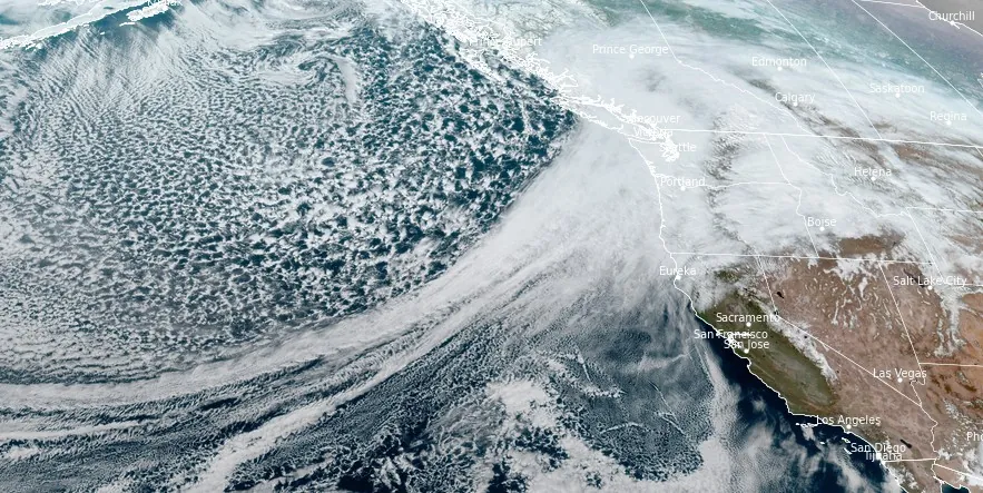
Image credit: NOAA/GOES-West, RAMMB/CIRA, The Watchers. Acquired at 22:30 UTC on February 28, 2024
An atmospheric river (AR) and low-pressure system are forecasted to bring widespread precipitation, including heavy snowfall in the Sierra Nevada and potential flooding along the US West Coast, from February 28 through March 3, 2024.
- The potential exists for snowfall totals on the order of 150 to 300 cm (5 – 10 feet) by Saturday evening, March 2, for the higher elevations of the Sierra, NWS warns. This will result in a travel nightmare for the mountain passes that are affected, and will likely result in numerous road closures.
- There will also be moderate to heavy snow for the higher terrain of the Northern Rockies, but not to the same magnitude as the Sierra and Cascades.
The Center for Western Weather and Water Extremes (CW3E) reports the AR made landfall over the Pacific Northwest and is expected to progress down the coast through February 29. This major weather event is forecasted to continue over California, fueled by a mid-level trough and the low-pressure system, until March 3.
With the potential for integrated vapor transport (IVT) from the central Pacific extending AR conditions, northern and central California are braced for prolonged precipitation.
The National Weather Service’s Weather Prediction Center (WPC) has forecasted significant precipitation along the Washington through Northern California coasts, including the Cascades and Sierra Nevada, over a five-day period.
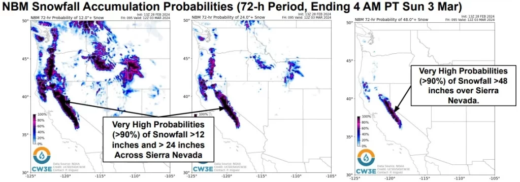
Snowfall predictions are particularly staggering for the Sierra Nevada, where the National Blend of Models (NBM) indicates a greater than 90% probability of snowfall exceeding 122 cm (48 inches), with potential accumulations surpassing 203 cm (80 inches). West-WRF Ensemble meteograms corroborate these forecasts, predicting significant snowfall totals exceeding 122 cm.
Furthermore, the WPC’s Excessive Rainfall Outlooks have issued a Marginal Risk of Flooding for coastal regions and the Sierra Nevada foothills.
“March will be coming in like a lion for the West Coast states,” NWS forecaster Hamrick noted. “An extremely potent winter storm will be making all kinds of weather headlines for the higher terrain of Washington, Oregon, and California, particularly for the Sierra going into Friday and Saturday.”
“A prolonged period of upslope flow, combined with abundant moisture from the Pacific and lowering snow levels, will result in a multi-day heavy snowfall event with blizzard conditions as winds gust well over 50 mph [80 km/h]. The potential exists for snowfall totals on the order of 5-10 feet [150 to 300 cm] by Saturday evening for the higher elevations of the Sierra!
“This will result in a travel nightmare for the mountain passes that are affected, and will likely result in numerous road closures. There will also be moderate to heavy snow for the higher terrain of the Northern Rockies, but not to the same magnitude as the Sierra and Cascades. Heavy rain is expected for the coastal areas between San Francisco and the Olympic Peninsula of Washington where a few inches are likely over the next 3 days.”
Authorities urge residents and visitors to stay alert to official forecasts, watches, and warnings through the National Weather Service and to heed guidance from local emergency management officials.
References:
1 CW3E AR Update: 28 February 2024 Outlook
2 Short Range Forecast Discussion – NWS Weather Prediction Center College Park MD – 241 PM EST Wed Feb 28 2024
I'm a dedicated researcher, journalist, and editor at The Watchers. With over 20 years of experience in the media industry, I specialize in hard science news, focusing on extreme weather, seismic and volcanic activity, space weather, and astronomy, including near-Earth objects and planetary defense strategies. You can reach me at teo /at/ watchers.news.
Commenting rules and guidelines
We value the thoughts and opinions of our readers and welcome healthy discussions on our website. In order to maintain a respectful and positive community, we ask that all commenters follow these rules.