
Intense winter storm brings heavy snow and freezing temperatures to the Plains and Rockies, U.S.
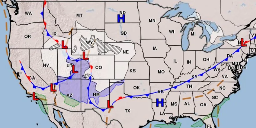
Image credit: NWS
A significant winter storm is affecting the Rockies and Plains, bringing heavy snowfall and temperatures well below normal this holiday weekend. Forecasts predict snow accumulations of 10 – 15 cm (4 – 6 inches) in western Nebraska and central Kansas, and up to 30 – 45 cm (12 – 18 inches) in southwest Colorado. The system, which is also expected to impact the eastern states early next week, poses a severe travel risk due to gusty winds and heavy snow.
A powerful winter storm is tracking across the Intermountain West into the central Plains, bringing a notable drop in temperatures and hazardous travel conditions. The storm’s path will impact areas from the eastern Great Basin through the central Rockies to the central High Plains. Western Nebraska and Kansas are preparing for snow accumulations of 10 – 15 cm (4 – 6 inches) on Friday and Saturday, November 24 and 25, 2023, with potential for higher amounts in some areas. Southwest Colorado is expected to receive significant snowfall, with estimates of 30 – 45 cm (12 – 18 inches).
The storm’s impact is intensified by gusty winds, with snow rates reaching up to 2.5 cm (1 inch) per hour at times. This combination is expected to create particularly hazardous conditions for travelers in western and central Kansas this Saturday. Additionally, a wintry mix is forecast from the Texas Panhandle through northern Oklahoma into eastern Kansas and Missouri, resulting in light snow accumulations.
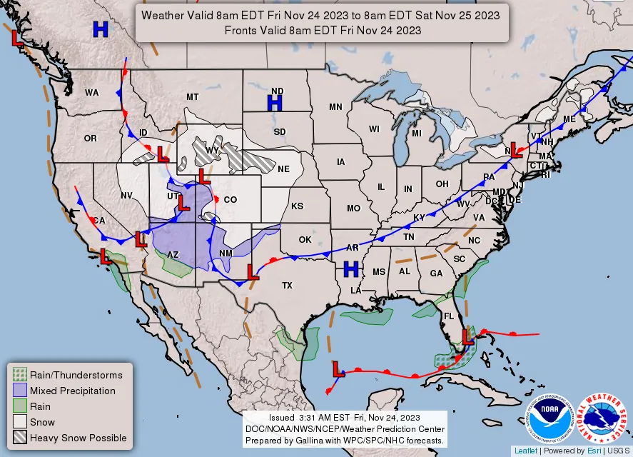
Following a cold front, below-average temperatures are anticipated for much of the U.S. this weekend. The central Plains will experience some of the most extreme temperature drops, with highs forecasted at -6 to 1 °C (20s and 30s °F) and morning lows dropping to -9 to -7 °C (16 – 19 °F). Wind chills in these areas could reach and even drop below -18 °C (0 °F).
The eastern U.S. will also face lower than average temperatures, with highs in the -6 to 1°C (20s and 30s °F) range for the Great Lakes and Interior Northeast. The Midwest, New England, and Mid-Atlantic states will see highs from 1 to 10°C (30s to 50s°F). The South, while warmer, will experience slightly below average temperatures.
The Northern/Central Rockies, Great Basin, and Four Corners Region expect highs of 1 to 4 °C (30s and 40s °F). The Desert Southwest will see highs of 15 to 20 °C (60s °F), whereas the West Coast, particularly northern California and the Pacific Northwest, will experience highs of 4 to 10 °C (40s and 50s °F). A notable concern is the San Joaquin Valley, where morning lows are expected to approach or drop below freezing.
References:
1 Short Range Forecast Discussion – NWS Weather Prediction Center College Park MD – 241 AM EST Fri Nov 24 2023
The Watchers team and our contributors bring the latest on extreme weather, earthquakes, volcanic eruptions, space weather, and all things science. We're all about making sense of the natural world and keeping you informed on what’s happening. Got a tip or a question? Hit us up using the form at newstips!
Commenting rules and guidelines
We value the thoughts and opinions of our readers and welcome healthy discussions on our website. In order to maintain a respectful and positive community, we ask that all commenters follow these rules.