
Increased underwater volcanic activity at Ahyi Seamount, alert level raised, Northern Mariana Islands
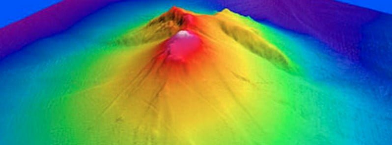
Image credit: Susan Merle (Oregon State University/NOAA Vents Program)
Increased underwater volcanic activity was detected at the Ahyi Seamount, Northern Mariana Islands on May 21, 2023, leading to the Aviation Color Code and Volcano Alert Level being raised to Yellow/Advisory.
The U.S Geological Survey (USGS) issued a Volcano Observatory Notice for Aviation (VONA) on May 22, 2023, indicating a spike in underwater volcanic activity at the Ahyi Seamount in the Northern Mariana Islands. Signals consistent with this eruptive activity started to appear around 12:10 UTC on May 21, 2023.
The early signals were observed through underwater pressure sensors at Wake Island, located 2 270 km (1 410 miles) east of Ahyi. Following these signs, a plume of discolored seawater was noticed above the previously active vent in a satellite image at 00:43 UTC on May 22, 2023. These observations prompted the USGS to raise the Aviation Color Code and Volcano Alert Level to Yellow/Advisory.
As far back as mid-October 2022, hydroacoustic sensors at Wake Island began recording signals in line with activity from an undersea volcanic source. A combined analysis of these signals and data from seismic stations located at Guam and Chichijima Island, Japan, carried out in collaboration with the Laboratoire de Geophysique in Tahiti, confirmed Ahyi Seamount as the source of this activity. This activity paused in early April but has now resumed.
No volcanic cloud has been produced at this time.
Geological summary
Ahyi Seamount is a large conical submarine volcano that rises to within 75 m (246 feet) of the sea surface about 18 km (11 miles) SE of the island of Farallon de Pajaros (Uracas) in the Northern Marianas.
Water discoloration has been observed there, and in 1979 the crew of a fishing boat felt shocks over the summit area of the seamount, followed by an upwelling of sulfur-bearing water.
On April 24 and 25, 2001 an explosive eruption was detected seismically by a station on Rangiroa Atoll, Tuamotu Archipelago. The event was well constrained (± 15 km / 9 miles) at a location near the southern base of Ahyi.
An eruption in April-May 2014 was detected by NOAA divers, hydroacoustic sensors, and seismic stations.
References:
1 Ahyi Seamount (VNUM #284141) VONA – USGS – May 22, 2023
2 Ahyi Seamount – Geological summary – GVP
I'm a dedicated researcher, journalist, and editor at The Watchers. With over 20 years of experience in the media industry, I specialize in hard science news, focusing on extreme weather, seismic and volcanic activity, space weather, and astronomy, including near-Earth objects and planetary defense strategies. You can reach me at teo /at/ watchers.news.
Commenting rules and guidelines
We value the thoughts and opinions of our readers and welcome healthy discussions on our website. In order to maintain a respectful and positive community, we ask that all commenters follow these rules.