
Unrest observed at Ahyi Seamount, Aviation Color Code raised to Yellow, Northern Mariana Islands

Image credit: USGS/Landsat-8, Culture Volcan
Satellite and remote geophysical data show signs of unrest at Ahyi Seamount, Northern Mariana Islands, prompting the USGS to raise the Aviation Color Code to Yellow and the Volcano Alert Level to Advisory on November 28, 2022.
- While marine hazards are already possible above or near the volcano, aviation hazards are possible only in event of increased activity.
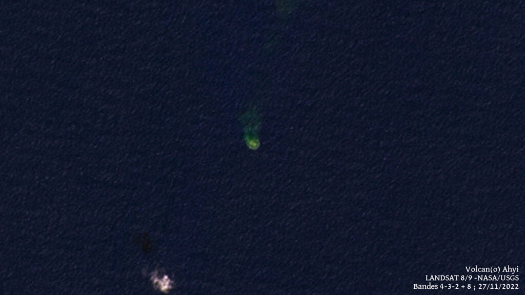
Signs of unrest at Ahyi Seamount have been observed in satellite and remote geophysical data. A plume of discolored water above Ahyi Seamount has been visible persistently in satellite data since November 18, 2022.
This discoloration could be due to degassing or eruption at the volcano, but we cannot say for certain due to a lack of local monitoring stations.1
Starting in mid-October, hydroacoustic sensors at Wake Island, 2 270 km (1 410 miles) east of Ahyi, began recording signals consistent with activity from an undersea volcanic source.
In collaboration with the Laboratoire de Geophysique in Tahiti, a recent combined analysis of the hydroacoustic signals together with data from seismic stations located at Guam and Chichijima Island, Japan, confirm that the source of this activity is at or near Ahyi seamount. Hydrophone signals continue to be observed but have decreased in the past few weeks.
Due to the current activity, the aviation color code is being raised from Unassigned to Yellow and the Alert Level from Unassigned to Advisory.
Geological summary
Ahyi seamount is a large conical submarine volcano that rises to within 75 m (246 feet) of the sea surface about 18 km (11 miles) SE of the island of Farallon de Pajaros (Uracas) in the Northern Marianas.
Water discoloration has been observed there, and in 1979 the crew of a fishing boat felt shocks over the summit area of the seamount, followed by an upwelling of sulfur-bearing water.
On April 24 and 25, 2001 an explosive eruption was detected seismically by a station on Rangiroa Atoll, Tuamotu Archipelago. The event was well constrained (± 15 km / 9 miles) at a location near the southern base of Ahyi.
An eruption in April-May 2014 was detected by NOAA divers, hydroacoustic sensors, and seismic stations.
References:
1 AHYI SEAMOUNT VOLCANO – NORTHERN MARIANA ISLANDS VOLCANO OBSERVATORY INFORMATION STATEMENT U.S. Geological Survey – November 28, 2022, 22:54 UTC
2 Ahyi – Geological summary – GVP
I'm a dedicated researcher, journalist, and editor at The Watchers. With over 20 years of experience in the media industry, I specialize in hard science news, focusing on extreme weather, seismic and volcanic activity, space weather, and astronomy, including near-Earth objects and planetary defense strategies. You can reach me at teo /at/ watchers.news.
Commenting rules and guidelines
We value the thoughts and opinions of our readers and welcome healthy discussions on our website. In order to maintain a respectful and positive community, we ask that all commenters follow these rules.