
Large to giant hail, damaging winds, and locally heavy rain expected from the southern Plains to the Midwest, U.S.
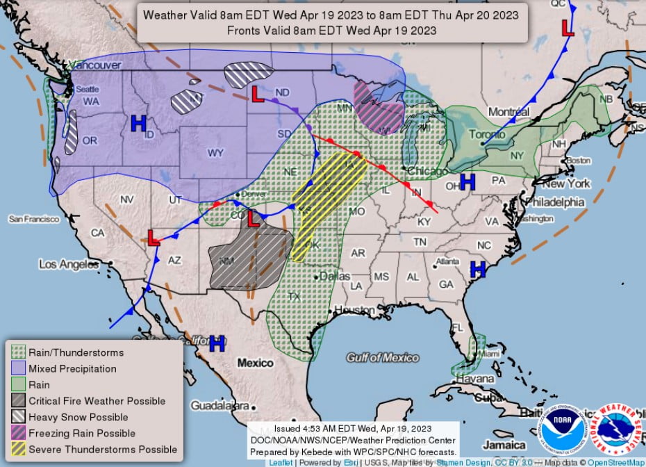
Image credit: NWS/WPC
A frontal system will bring the potential for severe storms with large to giant hail, damaging winds, and locally heavy rain from the southern Plains to the Midwest on Wednesday, April 19, and Thursday, April 20, 2023.
A frontal system is set to move eastward from the Northern/Central Plain to the Lower Great Lakes and southwestward to the Southern Plains from April 19 to 20, causing severe storms with large to giant hail, damaging winds, and locally heavy rain in the southern Plains and Midwest regions. Moisture will flow northward over the Southern/Central Plains into the Upper Midwest, leading to the development of showers and severe thunderstorms over parts of Oklahoma to Iowa.
The Storm Prediction Center (SPC) has issued a Slight Risk of severe thunderstorms over parts of the Middle Mississippi Valley and the Central/Southern Plains through Thursday morning. These thunderstorms pose various hazards, including frequent lightning, severe thunderstorm wind gusts, hail, and a few tornadoes. Parts of the Central/Southern High Plains face an even greater risk of 5 cm (2 inches) or larger hail.
Snow will develop over parts of the Northern High Plains and expand into the northernmost parts of the Northern Plains, further reaching parts of the Upper Mississippi Valley/Upper Great Lakes by Wednesday afternoon. Moderate to heavy rain will accompany thunderstorms from Kansas to Minnesota and Wisconsin, prompting the Weather Prediction Center (WPC) to issue a Marginal Risk of excessive rainfall for parts of the Central Plains, Upper/Middle Mississippi Valley, and Upper Great Lakes through Thursday morning. This heavy rain may result in localized flash flooding, particularly in areas with rapid runoff.
Showers and thunderstorms will move into the Great Lakes overnight on Wednesday. On Thursday, the front will push further south into Texas, bringing showers and severe thunderstorms. The SPC has issued a Slight Risk of severe thunderstorms over parts of the Middle/Lower Mississippi Valley and Southern Plains from Thursday into Friday morning, with hazards including frequent lightning, severe thunderstorm wind gusts, hail, and a few tornadoes. A greater risk of 5 cm (2 inches) or larger hail is expected over parts of the Southern High Plains.
References:
1 Short Range Forecast Discussion – NWS Weather Prediction Center College Park MD – 352 AM EDT Wed Apr 19 2023
I'm a dedicated researcher, journalist, and editor at The Watchers. With over 20 years of experience in the media industry, I specialize in hard science news, focusing on extreme weather, seismic and volcanic activity, space weather, and astronomy, including near-Earth objects and planetary defense strategies. You can reach me at teo /at/ watchers.news.
Commenting rules and guidelines
We value the thoughts and opinions of our readers and welcome healthy discussions on our website. In order to maintain a respectful and positive community, we ask that all commenters follow these rules.