
Tropical Cyclone “Ilsa” – Landfall expected as Category 4 cyclone, widespread impacts forecast across large parts of Western Australia
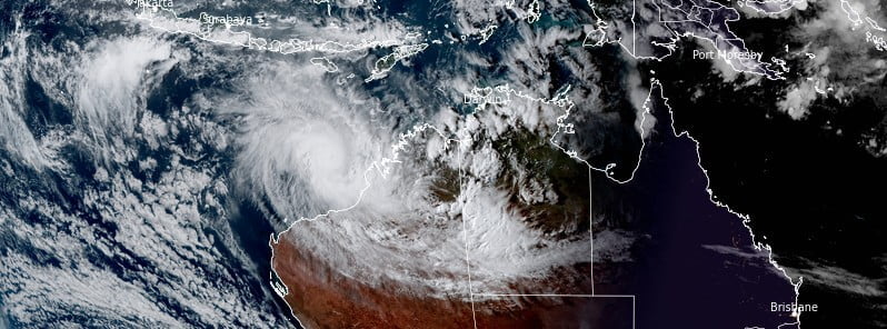
Featured image: Tropical Cyclone "Isla" at 07:50 UTC on April 12, 2023. Credit: JMA/Himawari-9, RAMMB/CIRA, The Watchers
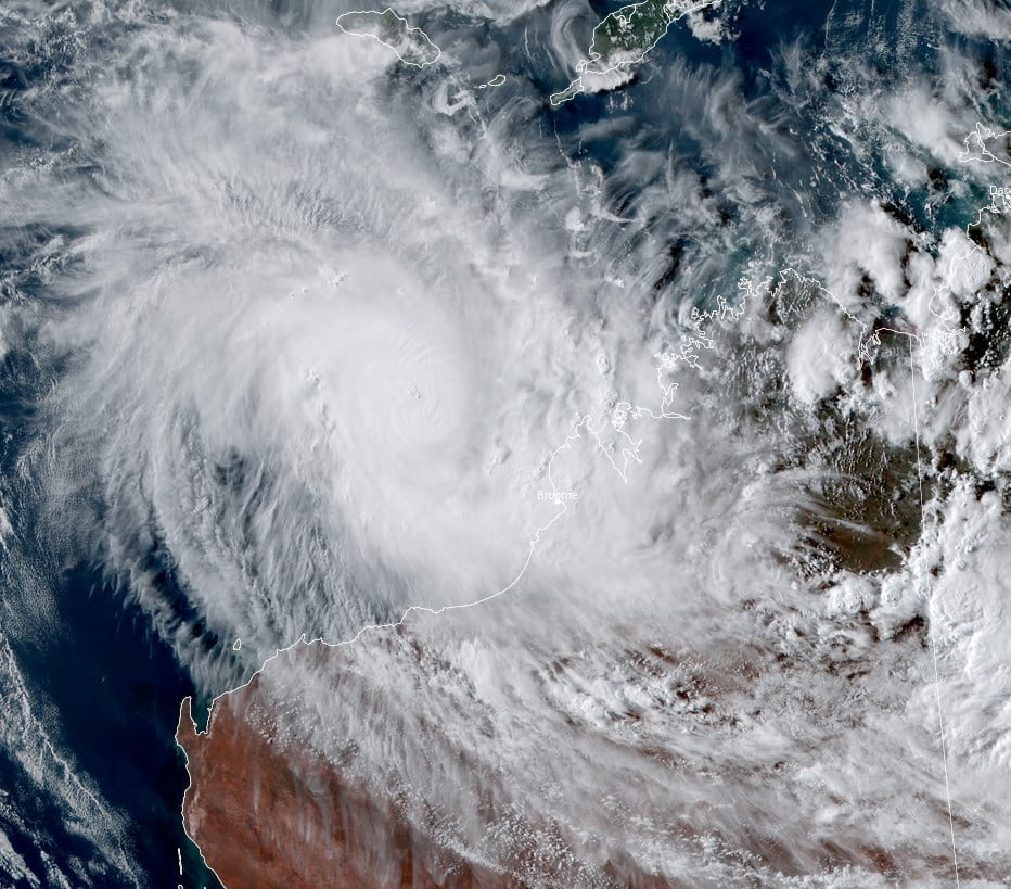
Tropical Storm “Ilsa” formed on Tuesday, April 11, 2023, near the coast of Western Australia as the 7th named storm of the 2022/23 Australian region cyclone season. Landfall is expected east of Port Hedland late Thursday or early Friday (LT), as a Category 4 cyclone on the Australian cyclone scale.
- The VERY DESTRUCTIVE CORE of Ilsa, with extreme gusts up to 270 km/h (168 mph) is expected to cross the coast between De Grey and west of Bidyadanga late Thursday night, April 13 or early Friday morning (LT), and move further inland Friday morning.
- Widespread impacts are likely across large parts of Western Australia and eventually Central Australia over the coming days.
At 06:00 UTC on April 12, Ilsa was a Category 3 cyclone with sustained winds near the center of 120 km/h (75 mph) with gusts to 165 km/h (102 mph).
Its center was located about 370 km (230 miles) NW of Broome and 500 km (310 miles) N of Port Hedland, Western Australia. The system was moving WSW at 7 km/h (4 mph).
Ilsa is expected to move southwest towards the Pilbara coast and reach Category 4 on Thursday morning.
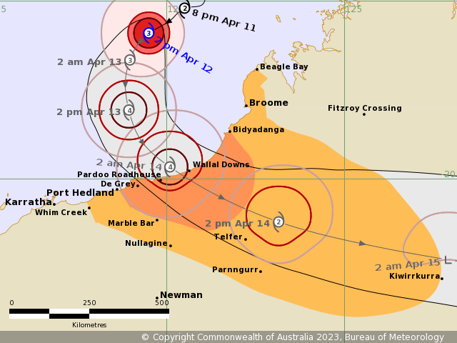
“A severe impact is likely along the coast and adjacent inland parts between east of Port Hedland and west of Bidyadanga, in the vicinity of Wallal Downs, during late Thursday or early Friday,” BOM meteorologists said in and update posted at 06:00 UTC today.
“During Friday, Ilsa is forecast to maintain tropical cyclone intensity as it tracks past Telfer and further inland across the Northern Interior district.”
Hazards
The VERY DESTRUCTIVE CORE of Ilsa, with extreme gusts up to 270 km/h (168 mph) is expected to cross the coast between De Grey and west of Bidyadanga late Thursday night, April 13 or early Friday morning (LT), and move further inland Friday morning.
DESTRUCTIVE WINDS with gusts to 155 km/h (96 mph) may develop near the coast between Bidyadanga and Port Hedland during Thursday afternoon or evening, extending inland as far as Marble Bar later on Thursday and to Telfer Friday morning.
DAMAGING WINDS with gusts to 90 km/h (56 mph) may develop between Bidyadanga and Port Hedland during early Thursday afternoon. DAMAGING winds may extend further west to Port Hedland later Thursday if Ilsa moves further to the west. DAMAGING WINDS may extend further to Beagle Bay later Thursday, including Broome, if Ilsa tracks further east. DAMAGING WINDS are expected to extend inland to Marble Bar during Thursday afternoon, to Telfer early Friday and to Kiwirrkurra by Friday evening.
HEAVY RAINFALL and squally thunderstorms are expected over the western Kimberley, and may extend to the eastern Pilbara from Thursday and Northern Interior from Friday. 200 to 400 mm (8 – 16 inches) of rainfall is possible during Thursday and Friday near where Ilsa crosses the coast.
ABNORMALLY HIGH TIDES are possible about the coast between Broome and Port Hedland during Wednesday, and Thursday. In some locations, the tide may be close to or exceed the highest astronomical tide of the year.
References:
1 Tropical Cyclone “Ilsa” – Tropical Cyclone Advice Number 23 – BOM – 06:00 UTC on April 12, 2023
I'm a dedicated researcher, journalist, and editor at The Watchers. With over 20 years of experience in the media industry, I specialize in hard science news, focusing on extreme weather, seismic and volcanic activity, space weather, and astronomy, including near-Earth objects and planetary defense strategies. You can reach me at teo /at/ watchers.news.
Commenting rules and guidelines
We value the thoughts and opinions of our readers and welcome healthy discussions on our website. In order to maintain a respectful and positive community, we ask that all commenters follow these rules.