
From space: A visual roundup of 2022’s global weather

Image credit: EUMETSAT
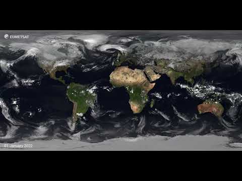
Take your seat and travel around the world to witness the planet’s weather in just under 10 minutes. In this annual visualization, EUMETSAT’s Training Manager, Mark Higgins, guides you through a mesmerizing view of Earth’s weather patterns captured from space.
This high-resolution visualization showcases the planet’s most significant storms, labeled with colors ranging from light yellow to red, depending on their intensity.
Through satellite imagery provided by EUMETSAT, we can see the entire planet, allowing us to create comprehensive views of global weather patterns that change with the seasons.
EUMETSAT’s international partners, including Météo-France, NASA, the National Ocean and Atmospheric Administration (NOAA) in the US, the China Meteorological Administration (CMA), and the Japan Meteorological Agency (JMA), have contributed to producing this video.

The Watchers team and our contributors bring the latest on extreme weather, earthquakes, volcanic eruptions, space weather, and all things science. We're all about making sense of the natural world and keeping you informed on what’s happening. Got a tip or a question? Hit us up using the form at newstips!
Published in the last 24 hours
- High Risk of excessive rainfall covers Florida’s Space Coast as St. Johns River near Cocoa reaches 5.67 m
- Asteroid 2026 WJ to pass Earth at 1.7 lunar distances at 04:20 UTC on November 22, with 2026 WD following at 4.4 lunar distances on November 23
- Cyclone Akvan crossed the north Andhra Pradesh and south Odisha coasts close to Gopalpur on November 20 with 70-80 km/h winds gusting to 90, and has weakened into a deep depression
- A broad low over southeastern Florida and the northwestern Bahamas has a 30 percent chance of subtropical or tropical development within 48 hours and a 50 percent chance within 7 days, the National Hurricane Center says
