
Major and anomalous storm system to produce widespread disruptive and potentially crippling impacts across the central and eastern U.S.
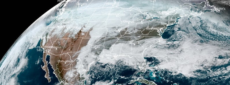
Image credit: NOAA/GOES-East, RAMMB/CIRA, The Watchers. Acquired at 18:20 UTC on December 21, 2022
An Arctic front will continue widespread, dangerous cold, with areas of blinding snow squalls and flash freezing over the central and eastern U.S. through the rest of this week. A strong winter storm will form on this front and bring blizzard conditions to the Plains, Upper Midwest, and Great Lakes. The eastern U.S. will see heavy rain, high winds, and coastal flooding ahead of the cold blast.
A major and anomalous storm system is forecast to produce a multitude of weather hazards through early this weekend, as heavy snowfall, strong winds, and dangerously cold temperatures span from the northern Great Basin through the Plains, Upper Midwest, Great Lakes, and the northern/central Appalachians, NWS forecaster Snell noted.1
At the forefront of the impressive weather pattern is a dangerous and record-breaking cold air mass in the wake of a strong Arctic cold front diving southward across the southern Plains today, December 22 and eastward into the Ohio/Tennessee Valleys by tonight.
Behind the front, temperatures across the central High Plains have already plummeted 28 °C (50 °F) in just a few hours, with widespread subzero (°F) readings extending throughout much of the central/northern Plains and northern Rockies/Great Basin.
These temperatures combined with sustained winds of 32 to 48 km/h (20 to 30 mph) and higher wind gusts of up to 95 km/h (60 mph) will continue to lead to wind chills as low as -40 °C (-40 °F) across a large swath of the Intermountain West and northern/central Plains, with more localized areas of -45 to -56 °C (-50 to -70 °F) possible through the end of the week.
Wind chills of this magnitude can cause frostbite in less than 5 minutes if precautions are not taken, with hypothermia and death also possible from prolonged exposure to the cold.
Livestock interests will also be severely impacted and dangers could be exacerbated if power outages occur.
Consequently, widespread Wind Chill Warnings, Watches and Advisories span across over 30 states from Washington to Florida.
Daytime temperatures across the central Plains will struggle to get above -18 °C (0 °F), while areas further south in Texas and the Gulf Coast will experience temperatures in the single digits and teens Thursday evening.
Furthermore, snow squalls, or a brief burst of moderate to heavy snow (lasting 1 to 2 hours), are likely to occur immediately behind the arctic front as it treks from the mid-Mississippi Valley to the East Coast.
Developing snow squalls could lead to extremely hazardous travel conditions at times, as they will be accompanied by gusts to 65 km/h (40 mph) and the potential for sudden whiteout conditions.
Lastly, areas with standing water ahead of the approaching cold front, particularly throughout the Ohio/Tennessee Valleys, could experience a flash freeze this afternoon and evening.
Roadways that were wet beforehand could freeze within a short period of time and lead to slick travel spots.
For areas across the Upper Midwest, Great Lakes, and Interior Northeast, a rapidly deepening low-pressure center that forms along the frontal boundary this evening and swings into the Great Lakes on Friday will have the potential to create potentially crippling conditions.
Widespread light-to-moderate snowfall is expected for this region, along with localized totals over a foot to the south and east of the Great Lakes where lake effect snow is forecast to linger into Saturday. The snowfall totals may not seem all that impressive with this storm, but combined with very strong winds over an extended period of time will create blizzard conditions that can bring travel to a halt and strain infrastructure.
These widespread wind gusts over 65 km/h (40 mph) and potentially up over 95 km/h (60 mph) are due to a very tight pressure gradient developing between the eventual low over the Great Lakes and the strong high pressure system over the northern Plains.
The abrupt deepening of this low pressure system will also aid in the increasingly large and powerful wind field.
Heavy snowfall rates of 25 – 50 mm (1 – 2 inches) per hour, along with wind gusts of over 80 km/h (50 mph) will result in near-zero visibility and considerable blowing and drifting of snow.
This will lead to dangerous, to at times impossible, land and air travel leading up to the holiday weekend.
The combination of heavy snow and strong wind gusts could lead to significant infrastructure impacts, including scattered tree damage and power outages.
Extreme cold entering the region could make conditions even more dangerous for locations that do lose power. Residents are advised to avoid travel if possible as the situation will become life-threatening if vehicles are stranded.
Blizzard Warnings and Winter Storm Warnings have been issued.
Further east in the warm sector of the strengthening storm system, moisture surging northward along and ahead of a coastal boundary situated off the Southeast coast will lead to moderate to heavy rainfall across the Mid-Atlantic and Northeast through early Friday. Rainfall totals of 25 – 75 mm (1 – 3 inches) are forecast.
As the wave of moisture tracks northward tonight, strong southerly winds ahead of the center of the storm, combined with the new moon-tide cycle, may lead to dangerous coastal flooding from the Delmarva Peninsula to Maine.
Furthermore, heavy rain over a fresh snowpack could also create scattered flooding concerns for much of Vermont and Maine on Friday, December 23 which has prompted a Slight Risk (level 2/4) of Excessive Rainfall to be issued.
Lastly, at the leading edge of the northward surging precipitation over the Mid-Atlantic during the first half of the day today, light freezing rain and locally heavy snowfall could impact parts of the central Appalachians.
A lingering cold air damming environment will likely keep this brief punch of wintry weather confined to the higher terrain and near the Blue Ridge mountains, but could still lead to snowfall totals of up to 150 mm (6 inches) in some spots.
Moreover, strong westerly winds will spread into the Mid-Atlantic and Northeast on Friday as the powerful arctic cold front completes its trek across the Nation.
A separate storm system is set to impact the Pacific Northwest beginning tonight and is anticipated to spread precipitation and gusty winds onshore ahead of an approaching warm front.
After initially starting as snow, sleet and freezing rain is likely to develop and could linger for an extended amount of time over parts of western Washington and northwestern Oregon.
This changeover to freezing rain is due to a dense arctic airmass remaining in place at the surface while warmer air surges over the region in the upper levels.
Localized ice accretion of a half inch could create the potential for dangerous travel conditions and scattered power outages by Friday.
References:
1 Short Range Forecast Discussion – NWS Weather Prediction Center College Park MD – 321 AM EST Thu Dec 22 2022
I'm a dedicated researcher, journalist, and editor at The Watchers. With over 20 years of experience in the media industry, I specialize in hard science news, focusing on extreme weather, seismic and volcanic activity, space weather, and astronomy, including near-Earth objects and planetary defense strategies. You can reach me at teo /at/ watchers.news.
Commenting rules and guidelines
We value the thoughts and opinions of our readers and welcome healthy discussions on our website. In order to maintain a respectful and positive community, we ask that all commenters follow these rules.