
Tropical Storm “Ma-on” to make landfall over Luzon, Philippines
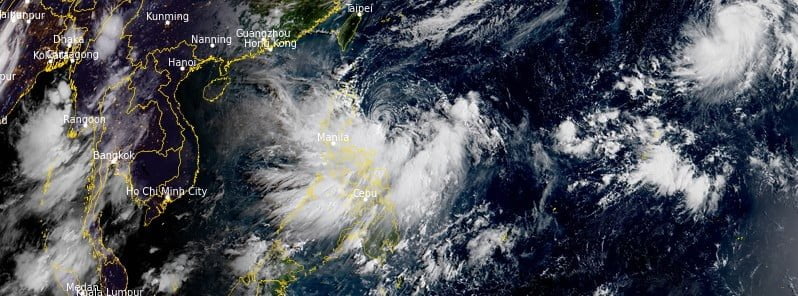
Featured image: Tropical Cyclone "Ma-on" at 23:10 UTC on August 21, 2022. Credit: JMA/Himawari-8, RAMMB/CIRA, The Watchers
Tropical Storm “Ma-on”—known as Florita in the Philippines—formed on August 21, 2022, east of the Philippines as the 9th named storm of the 2022 Pacific typhoon season. The storm is moving west at 15 km/h (9 mph) on August 22 and is expected to make landfall over northern Luzon around 18:00 UTC today.
At 06:00 UTC on August 22, Tropical Storm “Ma-on” (Florita) was located about 340 km (210 miles) east-northeast of Manila, Philippines.
Its maximum 10-minute sustained winds were 75 km/h (45 mph), with gusts up to 110 km/h (70 mph), while maximum 1-minute sustained winds were at 75 km/h (45 mph).
The minimum central barometric pressure was 996 hPa, and the system was moving west at 15 km/h (9.2 mph).
The system is expected to make landfall along the east coast of Luzon by around 18:00 UTC on August 22, then move across the northern portion of the island before emerging back into the South China Sea after 06:00 UTC on August 23.1
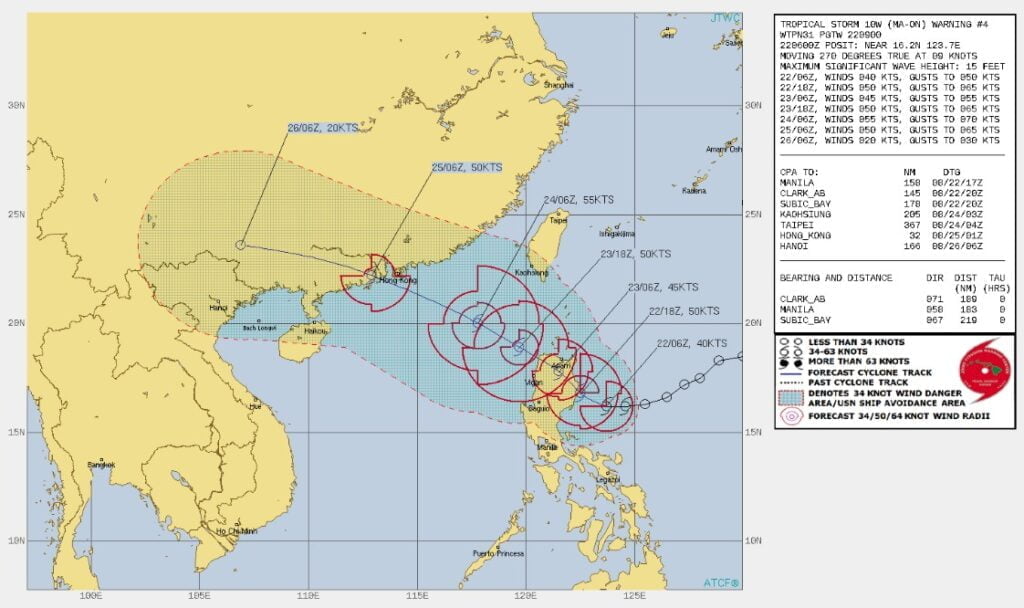
Once back over the water, the system is forecast to continue tracking northwestward towards a second landfall just south of Hong Kong around 06:00 UTC on August 25.
As the system has already demonstrated, it can intensify even in the face of strong vertical wind shear and this trend is expected to continue, reaching 90 km/h (55 mph) prior to landfall in Luzon.
Terrain interaction will cause the system to weaken slightly as it moves over Luzon.
Once over water again, the system is forecast to intensify once again, but at a slow pace due to a marginal upper-level environment expected to be in place at that time.
While the forecast peak is 100 km/h (60 mph), it is possible the system could reach a slightly higher peak prior to landfall in Hong Kong.
After landfall in southern China, the system will rapidly track westward and rapidly weaken and dissipate.
Hazards affecting land2
Heavy rainfall
August 22: Moderate to heavy with at times intense rains over Camarines Norte, Camarines Sur, and Quezon including Polillo Islands. Moderate to heavy rains over Ilocos Region, Apayao, and Cagayan. Light to moderate with at times heavy rains over Central Luzon, Batanes, Isabela, Mindoro Provinces, Romblon, Marinduque, Metro Manila, and the rest of CALABARZON, and Bicol Region.
August 23: Heavy to intense with at times torrential rains over Cagayan, Isabela, Batanes, Cordillera Administrative Region, and Ilocos Region. Moderate to heavy with at times intense rains over Aurora, Zambales, and Bataan. Light to moderate with at times heavy rains over the rest of Cagayan Valley and the rest of Central Luzon.
In the next 24 hours, the Southwest Monsoon will bring monsoon rains over Southern Luzon and Western Visayas.
Under these conditions, scattered to widespread flooding (including flash floods) and rain-induced landslides are expected especially in areas that are highly or very highly susceptible to these hazard as identified in hazard maps, and in localities with significant antecedent rainfall.
Severe winds
Winds may reach gale-force in strength in any of the areas where Wind Signal no. 2 is hoisted throughout the passage of the storm.
Strong winds (strong breeze to near gale strength) will be experienced within any of the areas where Wind Signal no. 1 is currently in effect.
In the next 24 hours, gusts reaching strong breeze to near gale strength may be experienced (especially in the coastal and mountainous areas) over Bicol Region, Batangas, Mindoro Provinces, Marinduque, Romblon, Northern Samar, Antique, and Aklan as Ma-on (Florita) begins to enhance the prevailing Southwest Monsoon.
Areas where Wind Signals are hoisted will be expanded in succeeding bulletins, while the hoisted wind signals in some localities of the country will likely be upgraded as Ma-on (Florita) moves closer.
Based on the track and intensity forecast, the highest possible wind signal that may be hoisted throughout the passage is TCWS #3.
Hazards affecting coastal waters
Under the influence of Tropical Storm “Ma-on” (Florita) and the prevailing Southwest Monsoon, Gale Warning remains in effect over the northern, eastern, and southern seaboards of Luzon and western seaboard of Visayas.
In the next 24 hours, the tropical storm will bring moderate to rough seas (1.2 to 2.8 m / 4 – 9 feet) over the western seaboards of Northern and Central Luzon and the eastern seaboards of Visayas and Mindanao. These conditions may be risky for those using small seacrafts. Mariners are advised to take precautionary measures when venturing out to sea and, if possible, avoid navigating in these conditions.
Tropical Cyclone Wind Signal no.2 (TCWS#2)
- Luzon
- Cagayan, Isabela, Quirino, the eastern portion of Nueva Vizcaya (Alfonso Castaneda, Dupax del Norte, Kasibu, Quezon, Bambang, Ambaguio, Bayombong, Solano, Villaverde, Bagabag, Diadi), Apayao, the eastern portion of Abra (Tubo, Boliney, Bucloc, Daguioman, Sallapadan, Licuan-Baay, Malibcong, Lacub, Tineg, Lagangilang, Bucay, Manabo, Luba), Kalinga, Mountain Province, Ifugao, and the northern and central portions of Aurora (Dilasag, Casiguran, Dinalungan, Dipaculao, Baler, Maria Aurora)
Tropical Cyclone Wind Signal no.1 (TCWS#1)
- Luzon
- Babuyan Islands, the rest of Nueva Vizcaya, the rest of Abra, Benguet, Ilocos Norte, Ilocos Sur, La Union, the eastern portion of Pangasinan (Urbiztondo, Bayambang, Bautista, Alcala, Santo Tomas, Rosales, Balungao, Umingan, San Quintin, Natividad, Tayug, San Nicolas, San Manuel, Asingan, San Carlos City, Lingayen, Binmaley, Basista, Malasiqui, Villasis, Santa Maria, City of Urdaneta, Binalonan, Laoac, Manaoag, Pozorrubio, Sison, San Fabian, San Jacinto, Mapandan, Santa Barbara, Mangaldan, Dagupan City, Calasiao), the eastern portion of Tarlac (San Manuel, Moncada, Anao, Paniqui, Ramos, Gerona, Pura, Victoria, City of Tarlac, Concepcion, La Paz), Nueva Ecija, the rest of Aurora, the eastern portion of Pampanga (Magalang, Arayat, Candaba), the eastern portion of Bulacan (San Miguel, Doña Remedios Trinidad, San Ildefonso, San Rafael, Angat, Norzagaray, City of San Jose del Monte), the northeastern portion of Rizal (Rodriguez, San Mateo, City of Antipolo, Tanay, Baras), the northern portion of Quezon (Infanta, General Nakar, Real) including Polillo Islands, the northern portion of Laguna (Santa Maria, Famy, Siniloan, Pangil, Pakil, Paete), and Camarines Norte
References:
1 Tropical Storm 10W (Ma-on) Warning #04 Issued at 22/0900Z – JTWC
2 Tropical Storm “Florita” Issued at 17:00 PHT, 22 August 2022 – PAGASA
I'm a dedicated researcher, journalist, and editor at The Watchers. With over 20 years of experience in the media industry, I specialize in hard science news, focusing on extreme weather, seismic and volcanic activity, space weather, and astronomy, including near-Earth objects and planetary defense strategies. You can reach me at teo /at/ watchers.news.
Commenting rules and guidelines
We value the thoughts and opinions of our readers and welcome healthy discussions on our website. In order to maintain a respectful and positive community, we ask that all commenters follow these rules.