
2021 Antelope Valley M6.0 earthquake, California, U.S.
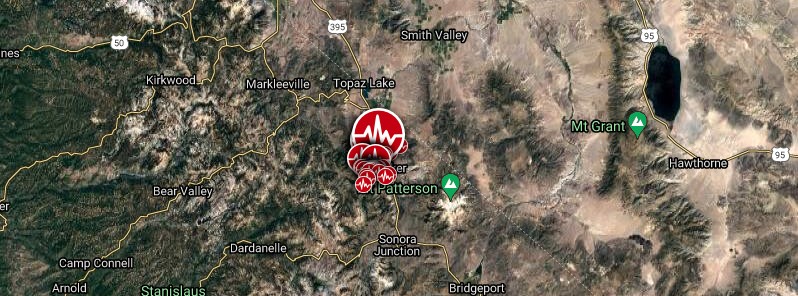
Image credit: TW/SAM, Google
A shallow M6.0 earthquake struck Little Antelope Valley, California, near the Nevada border at 22:49 UTC on July 8, 2021 (15:49 LT). This is the largest earthquake to hit California since the July 2019 Ridgecrest earthquake.
The epicenter was located about 32 km (20 miles) SW of Smith Valley, Nevada, and 32 km SE of Markleeville, California.
About 270 000 people live within 100 km (62 miles).
"Perceived shaking for the quake was very strong. The event was widely felt, with over 25 000 'Did You Feel It?' reports thus far submitted," the USGS said.
More than 470 aftershocks were reported until 10:00 UTC on July 10, with magnitudes ranging from 0.8 to 5.2.
"Preliminary focal mechanism solutions for the event, which describe the style of faulting in an earthquake, indicate slip likely occurred on a moderately dipping fault striking roughly north-south," the agency said.
"This motion is consistent with east-west oriented extension that is common in Nevada and eastern California. The earthquake occurred along the eastern edge of the Sierra Nevada, a major physiographic boundary along the California-Nevada border."
The event occurred at the margin of the stable Sierra Nevada microplate and the Walker Lane, a zone of distributed shear.
The microplate moves at about 12 mm/yr (0.5 inches per year) to the northwest relative to the North American plate. It is a part of the broader Pacific-North America plate boundary system of California, and roughly 25% of the 5 cm/yr (2 inches) total plate boundary motion occurs east of the Sierra Nevada.
Earthquakes in the vicinity include both normal faulting earthquakes and strike-slip earthquakes.
In the past 100 years, 33 earthquakes of M5+ or larger have occurred within 100 km (62 miles), with the largest a M6.1 earthquake 36 km (22 miles) to the northwest in September 1994, and a M6.1 earthquake 63 km (39 miles) to the north in June 1933.
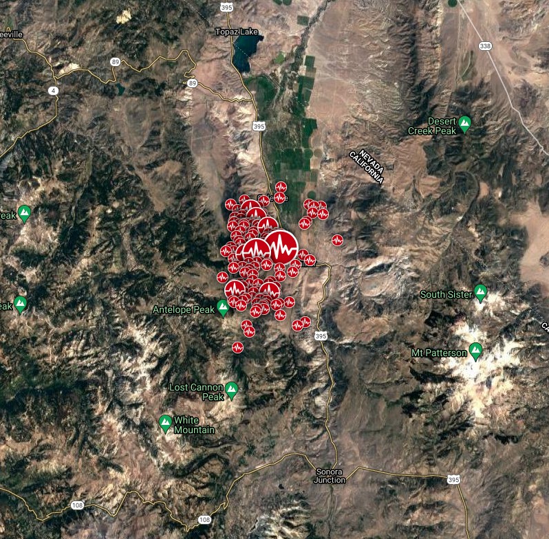

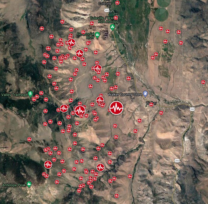
Image credit: TW/SAM, Google. Data source: USGS
Numerous large boulders tumbled down mountainsides and forced the police to close a stretch of California Highway 395 near Coleville — about 25 km (40 miles) of the road, from near the Willow Springs in Mono County north to the Nevada border. I395 is a major route through the northern Sierra Nevada.
Earthquake hit us on I395 near Coleville, CA! Boulders all over the road! #earthquake #California #roadtrip @ABC pic.twitter.com/ZoTxLnC6r8
— Brett Durrant (@brettdurrant) July 9, 2021
Boulders everywhere after earthquake on i395 #earthquake #california #roadtrip pic.twitter.com/Bdw4he17ni
— Brett Durrant (@brettdurrant) July 9, 2021
More info: This is called Centennial Bluff which is west of HWY 395. Here is a picture of a boulder that came down. Complete coverage right now on @nbcbayarea pic.twitter.com/h6I0LlHrMz
— Eric Rich (@ScoopRich) July 9, 2021
"While there are no preliminary reports of damage or injuries, this is a rapidly evolving situation and more details will emerge in the coming hours," California OES posted on Twitter on July 9. "We are working closely with local officials to ensure they have the resources and support to rapidly respond to these earthquakes."
ESA's Sentinel-1 satellite has mapped changes in distance to the ground surface.
"The bullseye pattern shows subsidence of ~10 cm [3.9 inches], indicating normal faulting. This displacement pattern results from deep movement along faults," the USGS scientists noted.
"In the absence of surface rupture along faults (this earthquake may not have reached the surface), we rely on satellite imaging, as well as detailed location of aftershock hypocenters, to determine which exact fault produced this earthquake. Results like this show rupture could be on an unmapped southern section of Slinkard Valley fault, with some deformation along a cross fault at the back of Little Antelope Valley. Some apparent offset in fringes may also line up with the Antelope Valley fault (north of Coleville)."
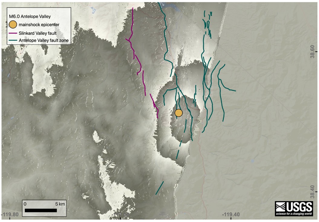
Image credit: Copernicus EU/Sentinel-1, USGS
The USGS advises everyone to be aware of the possibility of aftershocks, especially when in or around vulnerable structures such as unreinforced masonry buildings.
There is a 1 % chance of one or more aftershocks that are larger than magnitude 6.0 over the next 7 days. It is likely that there will be smaller earthquakes, with 4 to 27 magnitude 3 or higher aftershocks.
Magnitude 3 and above are large enough to be felt near the epicenter.
The number of aftershocks will drop off over time, but a large aftershock can increase the numbers again, temporarily.
I'm a dedicated researcher, journalist, and editor at The Watchers. With over 20 years of experience in the media industry, I specialize in hard science news, focusing on extreme weather, seismic and volcanic activity, space weather, and astronomy, including near-Earth objects and planetary defense strategies. You can reach me at teo /at/ watchers.news.
An example of Solar activity triggering earthquakes. Yesterday, TWO SOLAR FLARES, TWO RADIO BLACKOUTS: Departing sunspot AR2840 erupted twice on July 9th, producing a pair of almost-M-class solar flares. NASA’s Solar Dynamics Observatory captured the two ultraviolet flashes. Yesterday and today, there were also earthquakes in Indonesia and Central Asia. At least five people have died after an earthquake struck eastern Tajikistan, according to authorities in the mountainous country. The magnitude 5.9 quake hit 27km (17 miles) east of Rasht district this Saturday morning. The fact is that, after noticing the correlation between solar proton flux and strong earthquakes, some researchers are proposing a possible explanation of earthquakes: a mechanism called the reverse piezoelectric effect. Previous experiments have clearly shown that compressing quartz, a rock common in the Earth’s crust, can generate an electrical pulse through a process known as the piezoelectric effect. The researchers think that such small pulses could destabilize faults that are already close to rupturing, triggering earthquakes. In fact, signatures from electromagnetic events — such as earthquake lightning and radio waves — have been recorded occurring alongside earthquakes in the past. Some researchers think these events are caused by the earthquakes themselves. But several other studies have detected strong electromagnetic anomalies before large earthquakes, not after, so the exact nature of the relationship between earthquakes and electromagnetic events is still debated.
The new explanation, however, flips this electromagnetic cause-and-effect on its head, suggesting electromagnetic anomalies aren’t the result of earthquakes, but instead cause them. It goes like this: As positively charged protons from the Sun crash into Earth protective magnetic bubble, they create electromagnetic currents that propagate across the globe. Pulses created by these currents could then go on to deform quartz in Earth’s crust, ultimately triggering quakes.