
15 000 earthquakes hit the Reykjanes Peninsula since February 24, Iceland
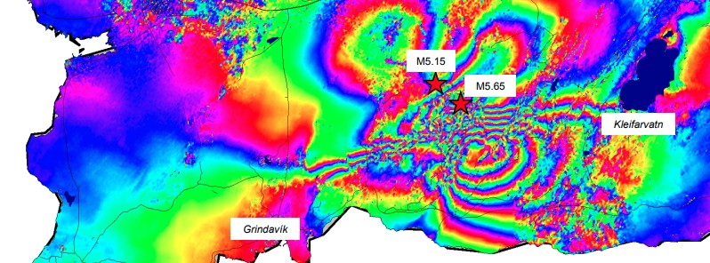
Image credit: Copernicus EU/Sentinel-1, IMO
The Icelandic Met Office (IMO) has detected around 15 000 earthquakes in Reykjanes Peninsula since an intense earthquake swarm started on February 24, 2021.
By March 1, the number rose to over 10 000 and by March 3 it's already around 15 000, with quite a few over M4.0 and two over M5.0.
Most of the activity is confined to the vicinity of Keilir and Trölladyngja, IMO said.
The Scientific Council for Civil Protection met at a teleconference on March 1. The meeting was attended by representatives from the Icelandic Meteorological Office, the University of Iceland, the Environment Agency, Isavia-ANS, HS-Orka, and ÍSOR.
The council reviewed satellite images (InSAR) and concluded that the most likely explanation is that magma is forming under the area where the greatest seismic activity has taken place in recent days.
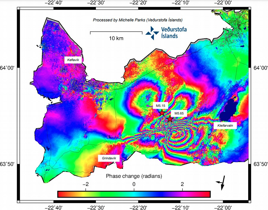
Image credit: Copernicus EU/Sentinel-1, IMO
In light of these new data, the council made several possible scenarios involving magma intrusion under Fagradalsfjall:
- The seismic activity reduces in the next few days or weeks.
- Seismicity increases with larger quakes, up to M6 in the vicinity of Fagradalsfjall.
- An earthquake of magnitude up to 6.5 will have its source in the Sulfur Mountains.
- Magma intrusions continue in the vicinity of Fagradalsfjall: (1) Magma intrusion activity decreases and magma solidifies; (2) The activity leads to a lava flow that will probably not threaten settlements.
It is difficult to predict the exact development and whether one scenario is more likely than another, IMO said.
New data is expected later this week that may shed more light.
Geological summary
The Reykjanes volcanic system at the SW tip of the Reykjanes Peninsula, where the Mid-Atlantic Ridge rises above sea level, comprises a broad area of postglacial basaltic crater rows and small shield volcanoes.
The submarine Reykjaneshryggur volcanic system is contiguous with and is considered part of the Reykjanes volcanic system, which is the westernmost of a series of four closely-spaced en-echelon fissure systems that extend diagonally across the Reykjanes Peninsula.
Most of the subaerial part of the volcanic system (also known as the Reykjanes/Svartsengi volcanic system) is covered by Holocene lavas.
Subaerial eruptions have occurred in historical time during the 13th century at several locations on the NE-SW-trending fissure system, and numerous submarine eruptions at Reykjaneshryggur dating back to the 12th century have been observed during historical time, some of which have formed ephemeral islands.
Basaltic rocks of probable Holocene age have been recovered during dredging operations, and tephra deposits from earlier Holocene eruptions are preserved on the nearby Reykjanes Peninsula. (GVP)
I'm a dedicated researcher, journalist, and editor at The Watchers. With over 20 years of experience in the media industry, I specialize in hard science news, focusing on extreme weather, seismic and volcanic activity, space weather, and astronomy, including near-Earth objects and planetary defense strategies. You can reach me at teo /at/ watchers.news.
Commenting rules and guidelines
We value the thoughts and opinions of our readers and welcome healthy discussions on our website. In order to maintain a respectful and positive community, we ask that all commenters follow these rules.