
A large storm to track across the United States, bringing severe thunderstorms, rain and snow
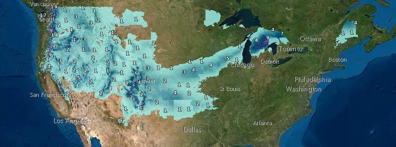
Featured image: Snow accumulation December 10 - 13, 2020. Credit: NWS
A storm over the Southwest will move northeastward to the Great Lakes through the coming weekend, bringing severe thunderstorms to the Southern Plains and Lower Mississippi Valley, showers to the Lower/Mid-Mississippi Valley, and snow from the central Plains to Great Lakes, the National Weather Service (NWS) warns. Rain, gusty winds, and mountain snow will impact the Pacific Northwest into the Northern Rockies through the weekend.
A developing storm over the southern Plains and Midwest will gradually strengthen and move northeast toward the Great Lakes by Saturday, December 12, 2020, NWS forecaster Snell noted at 07:24 UTC on Friday, December 11.
This system will produce higher elevation snow over the central/southern Rockies today, while also fueling showers and thunderstorms across the Arklatex region and Lower Mississippi Valley.
The snow over the central/southern Rockies will expand into the central Plains today. By this evening, rain and snow will develop over parts of the Upper/Middle Mississippi Valley.
As the storm moves into the Ohio Valley/Great Lakes on Saturday, moderate to heavy snow will develop over parts of the Great Lakes with rain/snow also pushing into parts of New England by Saturday evening.
Total snowfall amounts around 75 – 150 mm (3 to 6 inches) are forecast from southeast Nebraska to southern Wisconsin, with locally higher amounts possible. The highest snowfall is likely to occur across northern Michigan, where 150 – 300 mm (6 to 12 inches) of snow could accumulate.
This amount of snow will likely lead to treacherous travel across the region, Snell warned.
Ahead of the storm, widespread southerly winds will allow temperatures to become 5 to 10 °C (10 to 20 °F) above average over the country's eastern third. In comparison, parts of the central and southern High Plains will be 5 – 8 °C (10 to 15 °F) below average.
Lingering high elevation snow will be found across the Pacific Northwest and Intermountain West today as two energetic storm systems approach the West Coast.
The first system is an area of low pressure that is forecast to swing across the region this evening followed by a strong cold front on Sunday, December 13.
The biggest impact along the West Coast will be potentially heavy rain along coastal regions of northern California and Oregon.
Total rainfall amounts up to 100 mm (4 inches) are possible and could lead to isolated flooding.
Upwards of two feet of snow could fall across the Sierra and Cascade mountain ranges as well.
The aforementioned area of low pressure to impact the West Coast this evening is expected to move into the southern Rockies by Saturday evening and into the southern Plains by Sunday.
Light to moderate snow will be found to the north of the low across the central/southern Rockies and southern Plains.
There remains some uncertainty will exact snowfall amounts, but impactful winter weather will be possible from Colorado to central Oklahoma to end the weekend.
I'm a dedicated researcher, journalist, and editor at The Watchers. With over 20 years of experience in the media industry, I specialize in hard science news, focusing on extreme weather, seismic and volcanic activity, space weather, and astronomy, including near-Earth objects and planetary defense strategies. You can reach me at teo /at/ watchers.news.
Commenting rules and guidelines
We value the thoughts and opinions of our readers and welcome healthy discussions on our website. In order to maintain a respectful and positive community, we ask that all commenters follow these rules.